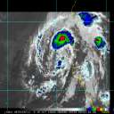
Ingrid's a very small storm, but a very well-defined one. The visible satellite image on the front page as well as on the NRL site hint at the possibility of mesovortices in the eye, while what other satellite imagery we have suggests a very symmetric storm. I don't see any hint of a concentric eyewall cycle to come, so it's possible that the storm gets a bit stronger yet. The storm looks very much like Isabel did on satellite, of course with the direction of rotation reversed.
These north Australian coast storms act quite a bit differently from those we see in the Atlantic. Many of these storms get their start from the monsoon trough found over Indonesia. Oftentimes they can meander while caught in the trough, then *usually* tend to move in a generally western direction with the tropical trades to landfall. (Note that storms that form well to the east of Australia tend to move in an easterly direction throughout their lifecycle.) Midlatitude troughs in the southern hemisphere tend to reach to much lower latitudes than they do in the northern hemisphere, resulting in storms being picked up near 15°S and recurved near 20°S in many circumstances. The projection for Ingrid brings it inland moving SW; whatever is left of it is likely to recurve offshore a day or three thereafter.
We don't have much in the way of model guidance for such a storm, but the GFS analyses suggest that the storm should continue to move towards the west and southwest towards the coast. The UWisc. satellite-derived products suggest that the storm is in a region of low wind shear and should remain so until landfall. There's a strong jet to the south of the storm over the central part of the continent which Ingrid will eventually be caught up in, but that's after landfall. Unfortunately, the mean layer wind analyses aren't produced by UWisc for the south Pacific, but there's nothing to suggest that the projected track is in error.
Damage near the landfall point will be confined to a small, fortunately relatively-low populated area, but will likely be pretty severe in localized regions.
Useful tools as the storm nears landfall:
Cairns, AU radar: http://mirror.bom.gov.au/products/IDR193.shtml
GOES-9 satellite imagery: http://cimss.ssec.wisc.edu/tropic/real-time/shemi/images/images.html
GFS analyses over Australia: http://grads.iges.org/pix/aus.00hr.html
UWisc satellite winds & analyses: http://cimss.ssec.wisc.edu/tropic/real-time/shemi/winds/winds.html
It's been a pretty active SW Pacific season so far in terms of major storms, with 5 category 4+ storms this year, but about average in terms of total systems (avg: 9 TCs, 4.5 hurricanes; based on 1966-1989 data). Kinda familiar, eh? In any case, best wishes to those in the path of this storm.
--------------------
Current Tropical Model Output Plots
(or view them on the main page for any active Atlantic storms!)
|


 Flat
Flat


