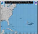
Rafael continues to decouple over the Gulf. Meanwhile we are keeping a watch on Invest 98L around the Bahamas and potentially a new low forming in the Caribbean.
Days since last H. Landfall - US: Any
31 (Milton)
, Major:
31 (Milton)
Florida - Any: 31 (Milton)
Major:
31 (Milton)
EDIT: Do not open attachment on this post, it likely wont open up. Please open the attachment pasted on the next post after reading. Sorry about that, gang.
Well, I am very proud of the National Hurricane Center this evening. As always, they have thouroughy discussed the parameters of their forecast. Tonight, they have also recognized that there may be a forecasting problem with the models and they have strayed in a very positive way...indicating that surprises may come, despite the model agreement (In other words, they are implementing/leaning on their synoptic meteorology 6th sense that things may notbe as they seem). Also, I appluad them for specifically stating that the Gulfstream IVmission was a near environment flight. In other words, they indicated that the flight data did not sample the total area needed to make adequate model adjustments, with particular mention to days 3,4,5. This must include the upper Bahamas Low and other weather downstream...In the end, thisonly makes sense, they can't fly only one plane everywhere in a couple hours and get good data
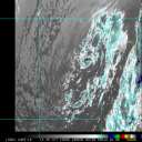
Tonight, my concerns do grow regarding the Bahamas low. If you have seen my previous posts on the previous thread, you will recall my statements on the Bahamas cut off low, high pressure ridges, jet stream interaction, and etc. Those comments still apply. I do grow more concerned about the Bahamas low becuase it may now be tapping into the jet stream, forming a jet stream split and a legitimate trough that may add strength to the TUTT like feature that is south of the Bahamas Low. In additional, the Bahamas low may be getting some help/ooph in getting a trough going by an UpperLow around 52N,72W. Over the course of the day, my Water vapor analysis has evolved into a true 3-D analysis (looking at systems and their combined interaction to the East, West, North, and south of Dean). All seem to be players to some degree or another. You really need to watch dowstream, upstream, north and south with this one. I have posted an attachment that showns the probable formation of a jet stream split as of this current time frame, after viewing it, I invite you to go to the following water Vapor Link (Don't forget to mash on the HDW-high radio button to see the wind barbs): http://www.ssd.noaa.gov/goes/east/nwatl/loop-wv.html
0 registered and 18 anonymous users are browsing this forum.
Moderator:
Forum Permissions
You cannot start new topics
You cannot reply to topics
HTML is disabled
UBBCode is enabled
Rating:
Thread views: 48783
Note: This is NOT an official page. It is run by weather hobbyists and should not be used as a replacement for official sources.
CFHC's main servers are currently located at Hostdime.com in Orlando, FL.
Image Server Network thanks to Mike Potts and Amazon Web Services. If you have static file hosting space that allows dns aliasing contact us to help out! Some Maps Provided by:
Great thanks to all who donated and everyone who uses the site as well.
Site designed for 800x600+ resolution
When in doubt, take the word of the National Hurricane Center