We've got two systems, that could develop, one southeast of Cape Hatteras, North Carolina (the longer shot) and one near Bermuda (Which may be a depression today).
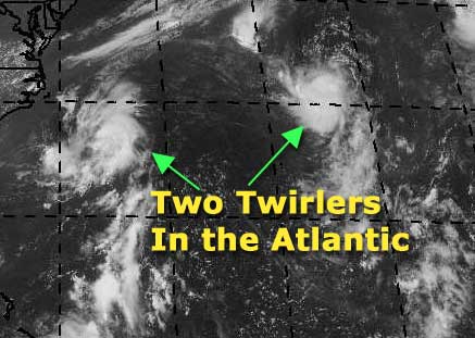
The Navy already has an eye on them, and so do I. The one near Bermuda is a candidate for the first depression of the year. It won't last long because of a low nearby, but it is something to track.
Let's throw up some chances:
On my development scale, where is the system southeast of Hatteras now?
code:

forget it) 0 1 2 3 4 5 6 7 8 9 10 (sure thing)

         [--*-------------------]
This one has a much lower chance to form, although it is showing some signs of spinning. Definitely don't want to write it totally off yet...
As for the Bermuda System..
code:

forget it) 0 1 2 3 4 5 6 7 8 9 10 (sure thing)

          [----------*-----------]
A much better chance, overall, and my personal choice for first almost if not complete tropical depression of 2002.
We'll See...
NASA GHCC Interactive Satellite images at:
North Atlantic Visible (Daytime Only), Infrared, Water Vapor
Some forecast models:
NGM, AVN, MRF, ETA ECMWF
DoD Weather Models (NOGAPS, AVN, MRF)
AVN, ECMWF, GFDL, MM5, NOGAPS, UKMET
Other commentary at Mike Anderson's East Coast Triopical Weather Center, Accuweather's Joe Bastardi, Hurricane City, Gary Gray's Millennium Weather, Even more on the links page.
- [mike@flhurricane.com]


 Flat
Flat


