Today marks the start of the Eastern Pacific Hurricane Season. Atlantic Outlooks also begin today.
Days since last Hurricane Landfall —
US Any:
590 (Milton),
US Major:
590 (Milton),
FL Any:
590 (Milton),
FL Major:
590 (Milton)
cieldumort
Moderator
Reged:
Posts: 2664
Loc: Austin, Tx
|
Tropical Storm Bonnie Lounge
Fri Jun 24 2022 02:44 AM
|
|
|
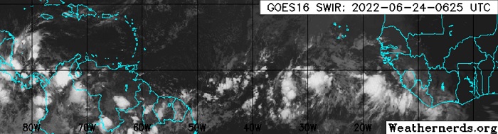
 Invest 94L in the far eastern Atlantic 6-24-22 0625z IR Image cr. Weathernderds.org
A stout tropical wave in the eastern Atlantic has the attention of an increasing number of models and indeed the NHC for unusually early Main Development Region Tropical Cyclogenesis, with a 50% NHC assigned chance of becoming a TC within 5 days, and this could be conservative.
Models are generally on fire for 94L in a way that sort of brings back memories, of 2005, and it is hard to find fault with their bullishness. While there is a long time for us to keep an eye on this wave and it is currently far out in the Atlantic, given the unseasonably favorable conditions for its development and model tracks that take it through the Caribbean as well as potentially into the Gulf of Mexico, we are starting a lounge on newly-Invest tagged 94L at this time.
PTC2 "Ptnl 2" sufficiently organized overnight June 30th and on July 1 has become Tropical Storm Bonnie. The title has been updated accordingly.
Edited by cieldumort (Fri Jul 01 2022 10:41 AM)
|
|
0 registered and 1 anonymous users are browsing this forum.
Moderator:
|
Forum Permissions
You cannot start new topics
You cannot reply to topics
HTML is disabled
UBBCode is enabled
|
Rating:
Thread views: 4315
|
|
|
|
|
|
Note: This is
NOT an official page. It is run by weather hobbyists and should not be used as a replacement for official sources.
CFHC's main servers are currently located at
Hostdime.com in Orlando, FL.
Image Server Network thanks to Mike Potts and Amazon Web Services. If you have static file hosting space that allows dns aliasing contact us to help out! Some Maps Provided by:
Great thanks to all who
donated and everyone who uses the site as well.
Site designed for 800x600+ resolution
When in doubt, take the word of the
National Hurricane Center