Current Radar or Satellite Image

Flhurricane.com - Central Florida Hurricane Center - Tracking Storms since 199531 Years of Hurricanes Without the Hype - Since 1995


Watches and/or Warnings could be required for Hawaii as soon as today with the regeneration of TD 15. Coastal Low developing near Gulf Stream.

Days since last Hurricane Landfall — US Any: 713 (Milton), US Major: 713 (Milton), FL Any: 713 (Milton), FL Major: 713 (Milton)
FlHurricane Atlantic Tropical Cyclone Tracking 🌀 Since 1995
30.8N -35.3W
Wind: 35MPH
Pres: 1011mb
Moving:
Present movement...wsw or 240 degrees at 9 mph...15 km/h
Click for Storm Spotlight
HypeScale:
4.00
0510
Communication
Storm Data
Content
Follow & Connect


Archives 2020s >> 2022 Forecast Lounge

cieldumortModerator
Moderator


Reged:
Posts: 2872
Loc: Austin, Tx
PTC4 Lounge
      Fri Aug 19 2022 10:51 AM


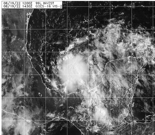
A convectively active tropical wave/broad low pressure system we have been tracking in near and over the Yucatan has become better defined this morning, and a tropical cyclone may be forming. Conditions continue to appear favorable for development and we are now starting a lounge on this system that is already very close to land.

NHC presently has a 40% odds of 99L becoming a numbered tropical cyclone within 48 hours, and this could be conservative.

Edited by CFHC (Fri Aug 19 2022 04:41 PM)

Post Extras Print Post   Remind Me!     Notify Moderator


Entire topic
Subject Posted by Posted on
* PTC4 Lounge cieldumortModerator Fri Aug 19 2022 10:51 AM

Extra information
0 registered and 0 anonymous users are browsing this forum.

Moderator:  cieldumort 


Forum Permissions
      You cannot start new topics
      You cannot reply to topics
      HTML is disabled
      UBBCode is enabled

Rating:
Thread views: 2288

Rate this thread

Jump to