Current Radar or Satellite Image

Flhurricane.com - Central Florida Hurricane Center - Tracking Storms since 199531 Years of Hurricanes Without the Hype - Since 1995


Nothing on the horizon for Atlantic development at the start of July.
Days since last Hurricane Landfall — US Any: 632 (Milton), US Major: 632 (Milton), FL Any: 632 (Milton), FL Major: 632 (Milton)
FlHurricane Atlantic Tropical Cyclone Tracking 🌀 Since 1995
None
HypeScale:
0.02
0510
Communication
Storm Data
Content
Follow & Connect


Archives 2020s >> 2023 Forecast Lounge

cieldumort
Moderator


Reged:
Posts: 2705
Loc: Austin, Tx
Re: 94L Lounge
      Thu Oct 12 2023 05:22 PM

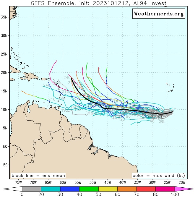
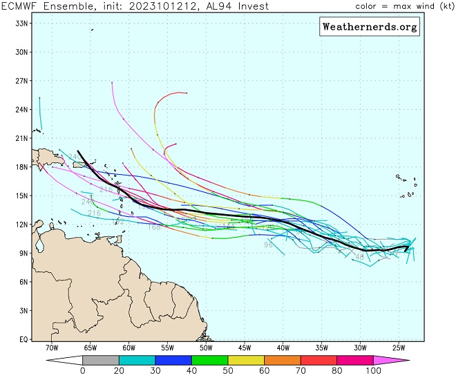
Models increasingly wash out Sean to the northwest of 94L without creating much of an escape hatch for 94L behind him, and instead build high pressure in his place, expanding well to the west, keeping 94L on a generally west to west-northwest heading for several days.

There is strong unanimity among the global models today in this scenario, which could put the eastern Caribbean islands at risk next week should these forecasts hold, and especially so should the more southern ensemble members verify better.

Here are the 12z Ensemble member plots for both the GFS and ECMWF (Cr. Weathernerds)


Post Extras Print Post   Remind Me!     Notify Moderator


Entire topic
Subject Posted by Posted on
* Tammy Lounge cieldumort Thu Oct 12 2023 05:22 PM
. * * Re: Tammy Lounge cieldumort   Sat Oct 21 2023 12:21 PM
. * * Re: Tammy Lounge IdaliaJackson   Thu Oct 19 2023 12:44 PM
. * * Re: Tammy Lounge cieldumort   Fri Oct 20 2023 02:08 AM
. * * Re: 94L Lounge cieldumort   Thu Oct 12 2023 05:22 PM
. * * Re: 94L Lounge cieldumort   Fri Oct 13 2023 12:54 PM

Extra information
0 registered and 21 anonymous users are browsing this forum.

Moderator:  


Forum Permissions
      You cannot start new topics
      You cannot reply to topics
      HTML is disabled
      UBBCode is enabled

Rating:
Thread views: 4223

Rate this thread

Jump to