Current Radar or Satellite Image

Flhurricane.com - Central Florida Hurricane Center - Tracking Storms since 199531 Years of Hurricanes Without the Hype - Since 1995


Nothing on the horizon for Atlantic development at the start of July.
Days since last Hurricane Landfall — US Any: 636 (Milton), US Major: 636 (Milton), FL Any: 636 (Milton), FL Major: 636 (Milton)
FlHurricane Atlantic Tropical Cyclone Tracking 🌀 Since 1995
None
HypeScale:
0.01
0510
Communication
Storm Data
Content
Follow & Connect


Archives 2020s >> 2024 News Talkbacks

MikeCAdministrator
Admin


Reged:
Posts: 4835
Loc: Orlando, FL
Re: Watching an area into August
      Fri Aug 02 2024 08:12 AM

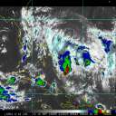
Trying to figure out when/where 97L will form, satellite shows an area of convection to the north of Cuba, and and an area to the South. Mid level and upper level seems to be just south of Cuba (Santiago), so the area seems split and unlikely to develop while near Cuba. Watching where this consolidates over the day (use combo of water vapor and visible sat imagery) will determine if the models have the initial setup right or not.


link to get above:
https://rammb-slider.cira.colostate.edu/...mp;draw_width=6


Post Extras Print Post   Remind Me!     Notify Moderator


Entire topic
Subject Posted by Posted on
* Watching an area into August MikeCAdministrator Fri Aug 02 2024 08:12 AM
. * * Re: Watching an area into August MikeCAdministrator   Fri Aug 02 2024 08:12 AM
. * * Re: Watching an area into August MikeCAdministrator   Thu Aug 01 2024 08:38 AM

Extra information
0 registered and 1 anonymous users are browsing this forum.

Moderator:  


Forum Permissions
      You cannot start new topics
      You cannot reply to topics
      HTML is disabled
      UBBCode is enabled

Rating:
Thread views: 6648

Rate this thread

Jump to