MikeC
Admin
Reged:
Posts: 4813
Loc: Orlando, FL
|
 Hurricane Ernesto
Sun Aug 11 2024 05:06 PM
|
|
|
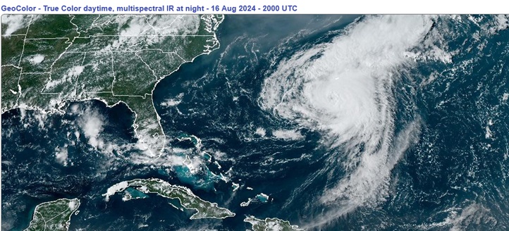
7:30PM EDT 16 August 2024 Update

Satellite imagery suggests that Ernesto may be intensifying a bit heading into a direct strike on Bermuda. Given Ernesto's very large windfield and off and on intrusions of dry air, this may not necessarily result in an increase in maximum sustained winds about its core, but could alternatively create a more sustained strong to damaging wind event. Either could be of concern.
Of greatest concern is likely to be the unusually high rainfall totals that are expected, with widespread 6 to 9 inch totals (150 to 225 mm) producing life threatening flash flooding.
Ciel
11:30AM EDT 15 August 2024 Update:
Ernesto has been ingesting some dry air that is slowing intensification, but Ernesto is a large and dangerous hurricane that will pass close to if not directly over Bermuda starting late Friday into the weekend. Preps to protect life and property there should be underway.
Ciel
5:30PM EDT 14 August 2024 Update:
Ernesto became a hurricane this morning, the third of the 2024 Atlantic Hurricane Season. According to Dr. Philip Klotzbach, just four other years in the satellite era (since 1966), have had three or more hurricanes in the basin by August 14: 1966, 1968, 1995 and 2005.
The cyclone is forecast to become and appears well on its way to becoming a Major within the next 48 hours, with a track that threatens a direct or indirect strike to the small island nation of Bermuda as soon as Friday night or early Saturday.
Ciel
8:10PM EDT 12 August 2024 Update:
Invest PTC FIVE developed a sufficiently well defined circulation this afternoon to be considered a tropical cyclone, and with sustained surface winds of about 40 MPH, NHC upgraded the system to Tropical Storm Ernesto, the fifth officiated tropical cyclone of the 2024 Atlantic Hurricane Season, ten days ahead of the climatolgical average of August 22nd.
Newly named Ernesto is still in rather formative stages and the center seems to be a bit jumpy. This could result in some adjustments being made to initial positions and ultimately future track and intensity. Recon is now aggressively flying the cyclone and this invaluable data will be fed into models going forward.
Interests from the Antilles to Bermuda may want to prepare for a potentially stout tropical storm, and perhaps later in the forecast period, very strong hurricane.
Ciel
7:30AM EDT 12 August 2024 Update:
Development continues to be slow this morning and the center may wind up being relocated a bit to the northwest later today, but a tropical storm is forecast to form likely tomorrow morning, and thus the watches have been extended to include the Virgin Islands and Puerto Rico, after this the system is forecast to turn north either just before or over Puerto Rico and head toward the north. Bermuda is in the cone later on.
Tropical Storm warnings are now up for St. Kitts, Nevis, Montserrat, Antigua, Barbuda, Anguilla, Guadeloupe, St. Martin,and St. Barthelemy
Original Update:
Potential Tropical Cyclone 5 has formed east of the Leeward Caribbean Islands, and tropical storm watches are up for Guadeloupe, St. Kitts, Nevis, Montserrat, Antigua, Barbuda, Anguilla, Saba, St. Eustatius, and St. Martin with watches possible for the Virgin Islands and Puerto Rico later.
It's forecast to only reach tropical storm strength before these islands currently. The next name on the list is Ernesto.
Beyond this it's forecast to recurve into the Atlantic east of the Bahamas and the US mainland, although Bermuda should watch it closely.
{{StormLinks|Ernesto|05|5|2024|Ernesto|Ernesto}}
{{StormCarib}}
{{BermudaNews}}
Edited by cieldumort (Fri Aug 16 2024 07:31 PM)
|
|