cieldumort
Moderator

Reged:
Posts: 2664
Loc: Austin, Tx
|
 Areas of Interest heading into Peak
Wed Sep 04 2024 05:06 PM
|
|
|
8:30AM EDT 7 September 2024 Update

An apparent increase in the risk of "home-grown" types this year neutralizes the unexpected lack of "Main Development Region" systems.
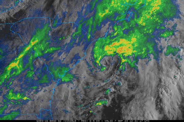
There is a striking well-developed Low off the coast of South Carolina this morning that by many measures has already acquired significant tropical characteristics. This has popped just within a few short hours and is not yet noted by NHC, but will likely be so soon if the cyclone holds. At present, it is tracking northeast. It is unclear how tied it remains to the parent non-tropical stationary front that has spawned several other less-impressive lows, including former 90L.
Elsewhere, the Wave now entering the southwestern Gulf has 60% NHC odds of development within the next few days and could pose a threat to Mexico, Texas and/or Louisiana.
5:30PM EDT 5 September 2024 Update

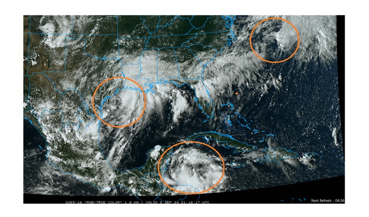
Above: Invest 90L (NW Gulf) Invest 99L (West of Bermuda) and Tropical Wave (NW Caribbean)
Three of the five AOIs in the Atlantic basin being monitored by NHC are arguably better candidates for development than advertised from the last NHC update, and as they are not just much closer to land, but already impacting large portions of the northwest and northern Gulf, Central America and at least indirectly the east coast and Bermuda and eastern Mexico, interests in these and nearby locations may want to begin paying closer attention and prepare for additional locally-issued and eventually potentially nationally-issued Watches and Warnings.
In addition to these three features that have the potential to become officiated tropical or subtropical cyclones, the parent front of 90L and 99L itself is wringing out copious moisture across the south including Florida resulting in dangerous flash flooding.
11AM EDT 5 September 2024 Update
Both the NW Gulf Low and Invest 99L off the east coast continue to develop and are likely to produce conditions much like an official Depression/Storm regardless of classification. We have opened up a Lounge on the NW Gulf Low at this time: 90L Forecast Lounge
9:30AM EDT 5 September 2024 Update
The Area of Interest in the northwestern Gulf of Mexico will likely have impacts much the same as a tropical depression whether or not development occurs, but there is also a window, however truncated by an approaching front, to become an official TD or storm, and those from the upper Texas coast to the Florida panhandle may want to give it some more attention. This feature is not yet Invest-tagged, but is now officially highlighted by NHC.
The AOI off the east coast is now Invest 99L and has a small window to acquire enough subtropical or tropical characteristics to be named.
In total, there are now 5 NHC-tracked AOIs in the Atlantic.
Original Update

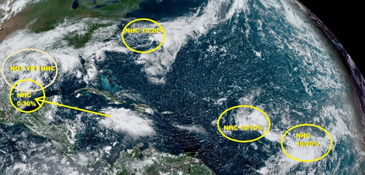
As of today, September 4, we now have four official lemon yellow slight areas of interest, plus one non-official area of interest already in the Gulf. While the overall background state of the Atlantic basin is far from ideal for TC genesis, it may be a little better than the past few weeks, and with this many disturbances to watch, one wouldn't be surprised to see something pop.
Considering that two of these systems are already very close to CONUS, we are starting a new article at this time. Not a single one of these AOIs is yet Invest-tagged, but conceivably could be relatively soon, and we will edit to provide links to its/their respective models, forecast lounges and such, as warranted.
It is already worth drawing extra attention to the AOI in the northwestern Gulf that is not yet highlighted by NHC. This broad area of low pressure with abundant tropical moisture to work with, but presently associated with the front that is also connected to the AOI off the east coast, could acquire some tropical characteristics over the next few days and separate from the front, and there are a few model runs to suggest that it either merges with the wave now centered south of Cuba and forecast to enter the southern GOM or develop on its own while staying further north. Regardless of development, heavy tropical rains are likely to persist across sections of the northwestern to central Gulf of Mexico where numerous Flash Flood Watches and Warnings are underway with more likely to come.
{{StormLinks|91L|91|6|2024|91|Invest 91L}}
{{StormLinks|92L|92|7|2024|92|Invest 92L}}
Edited by MikeC (Sun Sep 08 2024 08:20 AM)
|
|


 Flat
Flat

