cieldumort
Moderator
Reged:
Posts: 2713
Loc: Austin, Tx
|
 Helene Lounge
Wed Sep 18 2024 01:51 AM
|
|
|
As has been noted in the General Long Range Forecast Lounge, modeling has been trending warmer and warmer on the development of a Central American Gyre over this coming weekend that spins up an Atlantic side TC early next week.
As of 9/18/0z, global modeling is plenty compelling enough to start a lounge on this as-of-yet, only modeled system.
Central American Gyres are large, closed areas of low pressure that have two peak seasons: May through June, and then again September through November. As their name suggests, they are roughly centered over Central America.
There are two distinct types of CAGs: nonbaroclinic and baroclinic. Nonbaroclinic CAGs are by far the most common and are associated with an upper-level high. Baroclinic CAGs are far less common, and are characterized by an upper-level trof. The exact type of CAG can have large implications for the future location of TC genesis and track of any TC born from the parent broad area of low pressure. Most baroclinic CAGs form well north of where of where most nonbaroclinic CAGs do. Both types produce very heavy to extreme rainfall events, particularly along the Central American coastline.
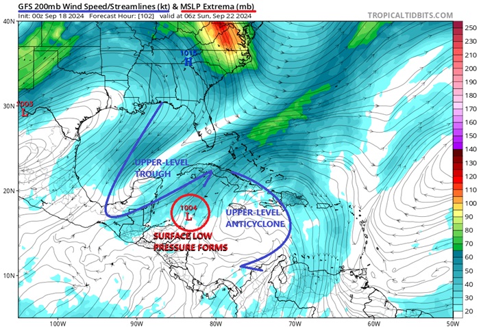
Over this coming weekend, an upper-level trough will drop far south into the GOM, forcing rising air across the western Caribbean and lowering pressures generally throughout this region, especially near or along our seemingly ever-present quasi-stationary coastal front, which itself is expected to slide into Central America and the northwestern Caribbean by then. By early next week, this ULL is likely to split, allowing an upper-level anticyclone to track further west and possibly colocate with the nascent area of surface low pressure near or over Central America, thus further increasing the potential for tropical cyclone genesis or perhaps already by this time, just increasing favorable conditions for continued strengthening.
Should the above play out as now most global models prognosticate, an area of tightening low pressure, possibly a TC, will be forming on the eastern to northeastern side of the CAG or along/just south of the front, likely in the northwestern Caribbean, with steering currents that might favor a north to northeast track.
Alternate solutions range from development more along the north to northwestern portion of the CAG (far less likely, but possible), only East Pac TC development (also far less likely, but possible), and no TC development at all (less likely, but somewhat possible).
ECMWF ensemble implied TC development odds in the western to northwestern Caribbean over the next 10 days are already over 70%.
As of 9/18/24 1:30AM EDT, the date and time of original entry, this area of low pressure is only a modeled forecast, and does not yet have an Invest tag. Should a disturbance form from this that does get Invest tagged, the title will be updated accordingly.
This developing system has just been Invest tagged today, Sep 22, and the title has been updated accordingly.
2024-09-22 18:00 15.3 -83.2 20
Official NHC Advisories on now Potential Tropical Cyclone NINE have begun as of 11AM EDT Sep 23 and the title has been updated accordingly.
Tropical Storm Helene 2024-09-24 18:00 19.4 -84.6 40
Ciel
Edited by cieldumort (Tue Sep 24 2024 03:41 PM)
|
|


 Flat
Flat


