Current Radar or Satellite Image

Flhurricane.com - Central Florida Hurricane Center - Tracking Storms since 199531 Years of Hurricanes Without the Hype - Since 1995


TROPICAL STORM MOKE LIKELY TO BRING HEAVY RAINFALL AND GUSTY WINDS TO PORTIONS OF THE HAWAIIAN ISLANDS THIS WEEKEND AND EARLY NEXT WEEK
Days since last Hurricane Landfall — US Any: 682 (Milton), US Major: 682 (Milton), FL Any: 682 (Milton), FL Major: 682 (Milton)
FlHurricane Atlantic Tropical Cyclone Tracking 🌀 Since 1995
HypeScale:
2.50
0510
Communication
Storm Data
Content
Follow & Connect


Archives 2020s >> 2024 News Talkbacks

cieldumortModerator
Moderator


Reged:
Posts: 2779
Loc: Austin, Tx
Re: Development Likely Close to Home
      Sun Sep 22 2024 03:21 PM


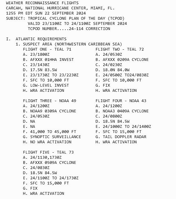
2. SUCCEEDING DAY OUTLOOK:
A. CONTINUE 6-HRLY FIXES IF SYSTEM DEVELOPS.
B. TWO MORE NOAA P-3 TAIL DOPPLER RADAR MISSIONS INTO THE SUSPECT AREA FOR 25/0000Z AND 25/1200Z, DEPARTING KLAL AT 24/2000Z AND 25/0800Z RESPECTIVELY.
C. TWO MORE NOAA G-IV SYNOPTIC SURVEILLANCE MISSIONS AROUND SUSPECT AREA FOR 25/0000Z AND 25/1200Z, DEPARTING KLAL AT 24/1730Z AND 25/0530Z RESPECTIVELY.

II. PACIFIC REQUIREMENTS
1. NEGATIVE RECONNAISSANCE REQUIREMENTS.
2. SUCCEEDING DAY OUTLOOK: POSSIBLE MISSION INTO SUSPECT AREA EP94 NEAR 15.8N 98.0W FOR 24/1730Z.

Post Extras Print Post   Remind Me!     Notify Moderator


Entire topic
Subject Posted by Posted on
* Hurricane Helene Incoming cieldumortModerator Sun Sep 22 2024 03:21 PM
. * * Re: Development Likely Close to Home cieldumortModerator   Sun Sep 22 2024 03:21 PM

Extra information
0 registered and 0 anonymous users are browsing this forum.

Moderator:  CFHC, MikeC, Ed Dunham, Colleen A., Atricks, danielw, Clark, Christine H, RedingtonBeachGuy, SkeetoBite, Bloodstar, tpratch, typhoon_tip, cieldumort, Jackie M, Wigeon, Hank Buck 


Forum Permissions
      You cannot start new topics
      You cannot reply to topics
      HTML is disabled
      UBBCode is enabled

Rating:
Thread views: 8569

Rate this thread

Jump to