Current Radar or Satellite Image

Flhurricane.com - Central Florida Hurricane Center - Tracking Storms since 199531 Years of Hurricanes Without the Hype - Since 1995


In the Atlantic, we are monitoring a wave exiting Africa for potential. In the Pacific, development somewhat close to Hawaii is also possible.
Days since last Hurricane Landfall — US Any: 667 (Milton), US Major: 667 (Milton), FL Any: 667 (Milton), FL Major: 667 (Milton)
FlHurricane Atlantic Tropical Cyclone Tracking 🌀 Since 1995
None
HypeScale:
0.35
0510
Communication
Storm Data
Content
Follow & Connect


Archives 2020s >> 2024 Forecast Lounge

cieldumortModerator
Moderator


Reged:
Posts: 2740
Loc: Austin, Tx
Re: Mid Nov Caribbean Invest TBD
      Tue Nov 12 2024 12:39 AM


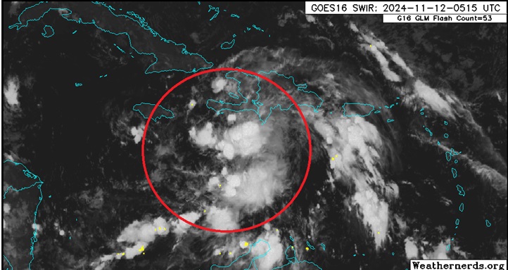
Above: Invest TBD in the north-central Caribbean tracking west to merge with a broader region of low pressure and favorable environment for further, quite possibly rapid development, later this week into next.


No vort-centric models are available yet. Here are some summaries of the 12/0z Globals that have locked on to this developing cyclone:

ICON
Apparent TD by Thursday in W Carib. Storm by Friday. HUR by Sunday. Major by Monday while tracking nw towards Yucatán. Scrapes/rounds Yucatán Monday as a Major. Enters south-central GOM by Tuesday (end of run)

GFS
Apparent TD by Wednesday evening sw of Jamaica. Storm Thursday just east of Nicaragua/Honduras. HUR Friday closer to Nic/Hon border tip. Major by Sat while still east Nic/Hon... meanders.. Cat 4 in this area by Sunday night. Tracks NW-NNW and enters Gulf between Yucatán and Cuba on Tuesday still Cat 3/4. Landfall around Naples-Fort Myers as Cat 3 Wed Nov 20th. Exits Fl on 21st, hooks ESE and rakes Bahamas Thurs and Fri Cat 2/1/Storm on weakening trend.

ECMWF
Apparent TD by Thursday ne of Nicaragua/Honduras border. Storm Friday N of Honduras. HUR by Sun while east of Nicaragua/Honduras border. Meanders, then beings tracking northwest and Majors Monday. Approaches the Yucatán Channel Tuesday night as a Cat 4/5. Landfall on western Cuba Wednesday night as a Major in the 3-4 range, perhaps. Tracks across western Cuba through end of run. Devastating solution for Cuba, if verified.


More details to come. This feature has the potential to become a very rare late-season landfalling Major hurricane.

Post Extras Print Post   Remind Me!     Notify Moderator


Entire topic
Subject Posted by Posted on
* Sara Lounge cieldumortModerator Tue Nov 12 2024 12:39 AM
. * * Re: Nineteen Lounge cieldumortModerator   Wed Nov 13 2024 09:01 PM
. * * Re: Nineteen Lounge JMII   Thu Nov 14 2024 01:35 PM
. * * Re: Invest 99L Lounge cieldumortModerator   Wed Nov 13 2024 09:51 AM
. * * Re: Invest 99L Lounge IsoFlame   Wed Nov 13 2024 11:36 AM
. * * Re: Invest 99L Lounge vineyardsaker   Wed Nov 13 2024 03:34 PM
. * * Re: Invest 99L Lounge JMII   Wed Nov 13 2024 04:09 PM
. * * Re: Invest 99L Lounge vineyardsaker   Wed Nov 13 2024 05:24 PM
. * * Re: Invest 99L Lounge cieldumortModerator   Tue Nov 12 2024 02:10 PM
. * * Re: Mid Nov Caribbean Invest TBD cieldumortModerator   Tue Nov 12 2024 12:39 AM
. * * Re: Mid Nov Caribbean Invest TBD JMII   Tue Nov 12 2024 07:00 PM
. * * Re: Mid Nov Caribbean Invest TBD IsoFlame   Tue Nov 12 2024 01:14 PM
. * * Re: Mid Nov Caribbean cieldumortModerator   Mon Nov 11 2024 11:56 AM

Extra information
0 registered and 1 anonymous users are browsing this forum.

Moderator:  CFHC, MikeC, Ed Dunham, Colleen A., Atricks, danielw, Clark, Christine H, RedingtonBeachGuy, SkeetoBite, Bloodstar, tpratch, typhoon_tip, cieldumort, Jackie M, Wigeon, Hank Buck 


Forum Permissions
      You cannot start new topics
      You cannot reply to topics
      HTML is disabled
      UBBCode is enabled

Rating:
Thread views: 15170

Rate this thread

Jump to