Current Radar or Satellite Image

Flhurricane.com - Central Florida Hurricane Center - Tracking Storms since 199530 Years of Hurricanes Without the Hype - Since 1995


Watching a 20% area in the east Antialnic. Conditions ahead of it are not very condusive for development. Right now, odds keep it likely weak/no development and it curves east of Bermuda.
Days since last H. Landfall - US: Any 325 (Milton) , Major: 325 (Milton) Florida - Any: 325 (Milton) Major: 325 (Milton)


News Talkback >> 2025 News Talkbacks

MikeCAdministrator
Admin


Reged:
Posts: 4782
Loc: Orlando, FL
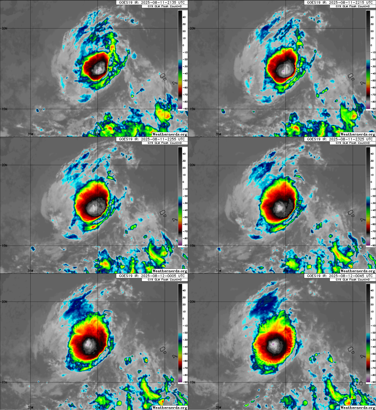
Re: Tropical Storm Erin Forms in the East Atlantic
      Mon Aug 11 2025 09:02 PM

Slight WSW drift tonight, but mostly heading due west.


Post Extras Print Post   Remind Me!     Notify Moderator


Entire topic
Subject Posted by Posted on
* Erin begins to leave the stage as others start to step in MikeCAdministrator Mon Aug 11 2025 09:02 PM
. * * Why bother Robert   Thu Aug 21 2025 01:25 PM
. * * Re: Erin Approaching Bahamas Turning More North Today cieldumort   Wed Aug 20 2025 11:00 AM
. * * Re: Erin Approaching Bahamas Turning More North Today CFHCAdministrator   Wed Aug 20 2025 10:56 AM
. * * Re: Erin Approaching Bahamas Turning More North Today cieldumort   Mon Aug 18 2025 05:54 PM
. * * Re: Erin Drawing Closer to East Coast/Bermuda and 98L in SW Gulf CFHCAdministrator   Mon Aug 18 2025 04:16 PM
. * * Re: Erin Drawing Closer to East Coast/Bermuda and 98L in SW Gulf cieldumort   Sat Aug 16 2025 04:39 PM
. * * Re: Erin Drawing Closer to East Coast and Islands cieldumort   Sat Aug 16 2025 01:15 PM
. * * Re: Erin Drawing Closer to East Coast/Bermuda and 98L in SW Gulf MichaelA   Sat Aug 16 2025 01:08 PM
. * * Re: Erin Drawing Closer to East Coast/Bermuda and 98L in SW Gulf MikeCAdministrator   Sat Aug 16 2025 10:33 AM
. * * Re: Erin Drawing Closer to East Coast/Bermuda and 98L in SW Gulf MikeCAdministrator   Fri Aug 15 2025 11:27 AM
. * * Re: Erin Drawing Closer to East Coast/Bermuda and 98L in SW Gulf cieldumort   Fri Aug 15 2025 09:30 AM
. * * Re: Tropical Storm Erin Forms in the East Atlantic MikeCAdministrator   Thu Aug 14 2025 08:27 PM
. * * Re: Tropical Storm Erin Forms in the East Atlantic CFHCAdministrator   Thu Aug 14 2025 01:15 PM
. * * Re: Tropical Storm Erin Forms in the East Atlantic MikeCAdministrator   Wed Aug 13 2025 07:52 AM
. * * Re: Tropical Storm Erin Forms in the East Atlantic Kraig   Tue Aug 12 2025 12:11 PM
. * * Re: Tropical Storm Erin Forms in the East Atlantic MikeCAdministrator   Mon Aug 11 2025 09:02 PM
. * * Re: Tropical Storm Erin Forms in the East Atlantic cieldumort   Mon Aug 11 2025 05:11 PM
. * * Re: Watcihing a Long Track in Mid-August CFHCAdministrator   Mon Aug 11 2025 03:47 PM
. * * Re: Watcihing a Long Track in Mid-August MikeCAdministrator   Mon Aug 11 2025 09:51 AM
. * * Re: Watcihing a Long Track in Mid-August MikeCAdministrator   Sun Aug 10 2025 08:31 PM
. * * Re: Watcihing a Long Track in Mid-August MikeCAdministrator   Sun Aug 10 2025 08:21 AM

Extra information
0 registered and 16 anonymous users are browsing this forum.

Moderator:  


Forum Permissions
      You cannot start new topics
      You cannot reply to topics
      HTML is disabled
      UBBCode is enabled

Rating:
Thread views: 10417

Rate this thread

Jump to

Note: This is NOT an official page. It is run by weather hobbyists and should not be used as a replacement for official sources. 
CFHC's main servers are currently located at Hostdime.com in Orlando, FL.
Image Server Network thanks to Mike Potts and Amazon Web Services. If you have static file hosting space that allows dns aliasing contact us to help out! Some Maps Provided by:
Great thanks to all who donated and everyone who uses the site as well. Site designed for 800x600+ resolution
When in doubt, take the word of the National Hurricane Center