Current Radar or Satellite Image

Flhurricane.com - Central Florida Hurricane Center - Tracking Storms since 199531 Years of Hurricanes Without the Hype - Since 1995


Arthur degenerates to a low pressure area.
Days since last Hurricane Landfall — US Any: 616 (Milton), US Major: 616 (Milton), FL Any: 616 (Milton), FL Major: 616 (Milton)
FlHurricane Atlantic Tropical Cyclone Tracking 🌀 Since 1995
29.7N -94.5W
Wind: 35MPH
Pres: 1000mb
Moving:
Present movement...ne or 40 degrees at 9 mph...15 km/h
Click for Storm Spotlight
HypeScale:
1.50
0510
Communication
Storm Data
Content
Follow & Connect


Archives 2020s >> 2025 News Talkbacks

cieldumort
Moderator


Reged:
Posts: 2705
Loc: Austin, Tx
Re: Basin Enters Peak
      Sun Aug 24 2025 04:25 PM

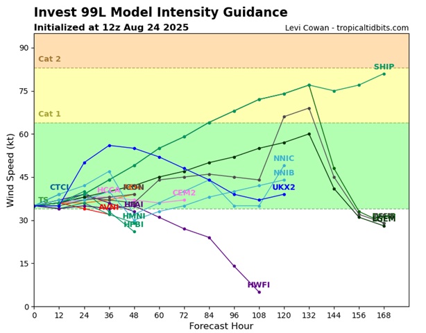
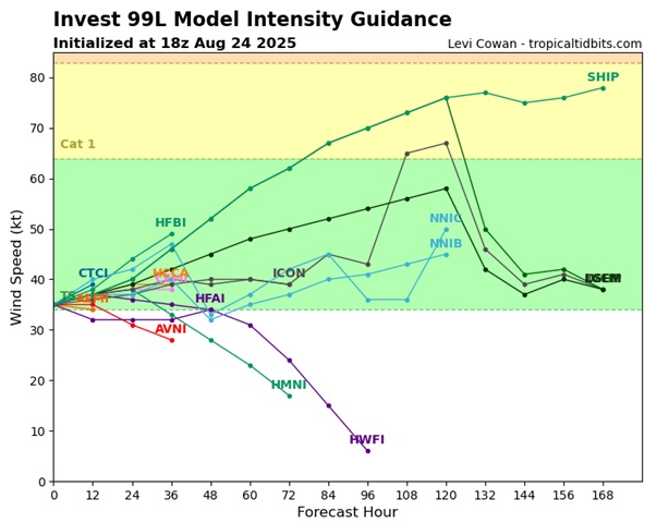
Today's 12z and 18z intensity guidance suggests that should 99L survive, which presently looks to be about a coin toss but decreasing, a majority calls for steady-state to even gradual strengthening for several days. Currently, 99L is estimated to have 35 knot max sustained winds at the surface based on scatterometer data and Dvorak classifications. Recon so far marginally supports this estimated max sustained wind as well.


Post Extras Print Post   Remind Me!     Notify Moderator


Entire topic
Subject Posted by Posted on
* Basin Enters Peak cieldumort Sun Aug 24 2025 04:25 PM
. * * Re: Basin Enters Peak cieldumort   Sun Aug 24 2025 04:25 PM
. * * Re: Basin Enters Peak MikeCAdministrator   Sun Aug 24 2025 07:59 AM
. * * Re: Basin Enters Peak cieldumort   Sat Aug 23 2025 04:24 PM

Extra information
0 registered and 1 anonymous users are browsing this forum.

Moderator:  


Forum Permissions
      You cannot start new topics
      You cannot reply to topics
      HTML is disabled
      UBBCode is enabled

Rating:
Thread views: 18239

Rate this thread

Jump to