New Article: CSU releases 2026 season numbers, slightly below average. https://flhurricane.com
Days since last Hurricane Landfall —
US Any:
562 (Milton),
US Major:
562 (Milton),
FL Any:
562 (Milton),
FL Major:
562 (Milton)
cieldumort
Moderator
Reged:
Posts: 2664
Loc: Austin, Tx
|
 Re: Hurricane Lorena (Potential SW US impacts)
Wed Sep 03 2025 11:40 AM
|
|
|

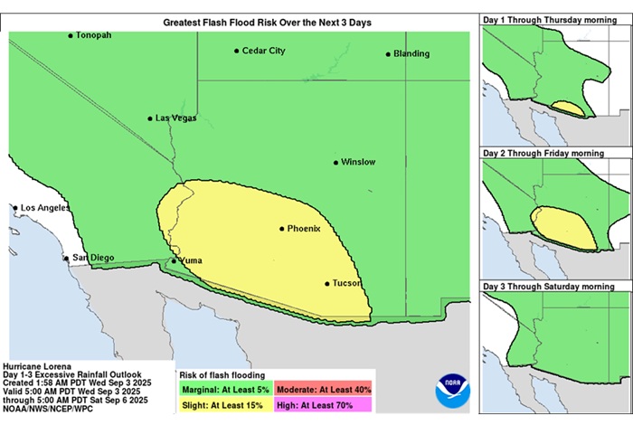
WPC Updated Day 1 Excessive Rainfall Outlook Quote:
Excessive Rainfall Discussion
NWS Weather Prediction Center College Park MD
1135 AM EDT Wed Sep 3 2025
Day 1
Valid 16Z Wed Sep 03 2025 - 12Z Thu Sep 04 2025
...THERE IS A SLIGHT RISK FOR EXCESSIVE RAINFALL FOR PORTIONS OF SOUTHERN ARIZONA...
...Southwest...
16Z Update: 12z CAMs have reasonable continuity from the previous forecast leading to similar probs based off the latest 12z HREF. Highest threat will be over Santa Cruz and Pima counties with the northern edge brushing southern Pinal and Maricopa. 12z KPSR sounding came in with a 1.47" PWAT, enough for a 90th percentile climo with higher PWATs forecasted south of Phoenix. This environment is plenty reason for any cell maturation to produce
locally 1-2"/hr rates that could spell problems for any of the desert locations south of I-10. For this reason, there were only some minor adjustments overall to the inherited SLGT risk with a touch further north extension to match trends in QPF from the latest CAMs.
Kleebauer
..Previous Discussion..
A broad area of instability and above normal moisture will bring a localized flash flood risk to much of the southwestern U.S. today. HREF guidance indicates the best convective coverage will be across southern AZ where neighborhood probabilities of 2"+ amounts are 30-50%. This generally looks to be where the better instability is forecast today, and also where the heaviest rainfall occurred yesterday. Thus maintaining the Slight risk across this areas seems reasonable.
Chenard
|
|
0 registered and 17 anonymous users are browsing this forum.
Moderator:
|
Forum Permissions
You cannot start new topics
You cannot reply to topics
HTML is disabled
UBBCode is enabled
|
Rating:
Thread views: 3983
|
|
|
|
|
|
Note: This is
NOT an official page. It is run by weather hobbyists and should not be used as a replacement for official sources.
CFHC's main servers are currently located at
Hostdime.com in Orlando, FL.
Image Server Network thanks to Mike Potts and Amazon Web Services. If you have static file hosting space that allows dns aliasing contact us to help out! Some Maps Provided by:
Great thanks to all who
donated and everyone who uses the site as well.
Site designed for 800x600+ resolution
When in doubt, take the word of the
National Hurricane Center
G