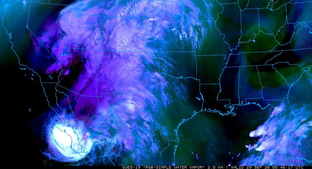
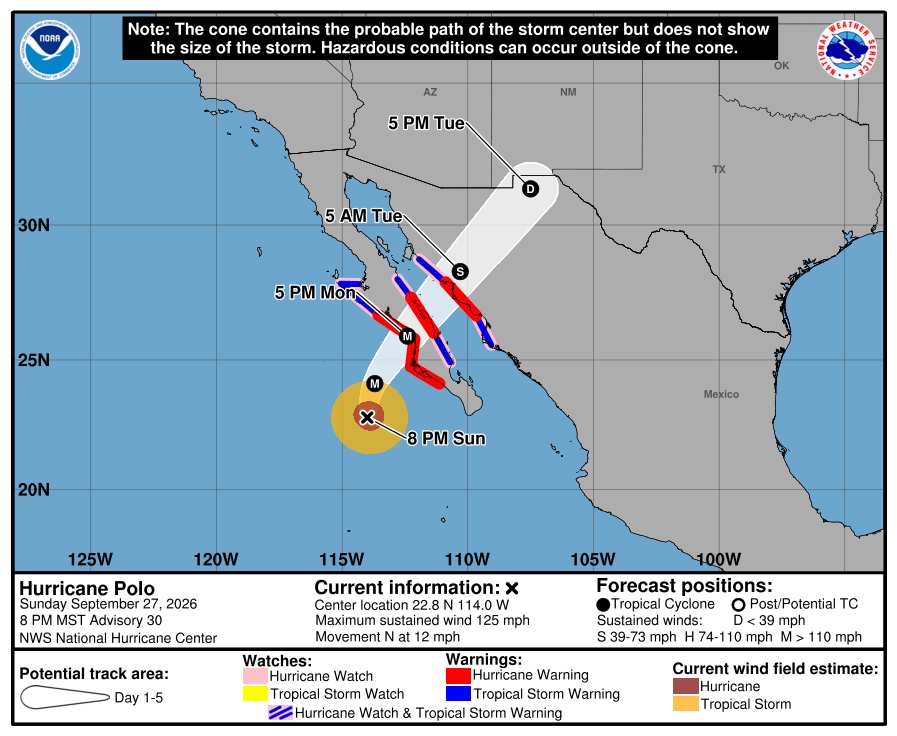
11:30PM MDT 28 September, 2026 Update Hurricane Polo is making landfall, estimated by Dvorak techniques to be somewhere in the range of Cat 2/3 at landfall, officially Cat 3 as of last NHC Advisory. Some weakening should occur while quickly tracking over the narrow peninsula, then perhaps some leveling off or even reintensification while in the Gulf of California prior to second and final landfall in northwestern mainland Mexico. Forward speed in response to an approaching mid-upper level trof that is amplifying over the southwestern US should increase and the cyclone or its remnant lows could be crossing over into the United States around southern or southeastern New Mexico, or possibly as far east as extreme southwestern Texas, by Wednesday morning.
This is a dangerous setup for a very widespread, multi-day flash flooding event, and the Weather Prediction Center has already hoisted its largest ever Moderate Risk (level 3 out of 4) of Flash Flooding, and once fine details become clearer, zones of High Risk(s) are not out of the question. Locally catastrophic and life-threatening flash flooding within large swaths of the southwestern to central United States is on tap for the week ahead. Ciel
Original Update Another Pacific hurricane threatening the United States, this time from the southwest: Major Hurricane Polo.
Polo is likely to bring substantial direct and indirect impacts to the southwestern to central United States after making landfall twice on northwestern Mexico. Interests in and along the Baja California within the warned areas should be rushing preps to protect life and property to completion from a landfalling serious hurricane.
Once further inland, Polo and/or its remnants will track into the United States by way of New Mexico/eastern Arizona/western Texas, and combined with a Predecessor Rain Event (PRE), is set to produce widespread and potentially locally catastrophic and life-threatening flash flooding throughout multiple southwestern-central US and northwestern MX states.
More modeling on Hurricane Polo and deep-dive details into US flooding potential can be found in the Forum under "Other Storm Basins" Hurricane Polo (de facto Lounge)
Elsewhere, now Major Hurricane Nolo continues pulling away from the Big Island of Hawaii to the west, while in the Atlantic, TD Fay and Invest 91L spin more fish. Gonzalo is falling apart in the far eastern Atlantic.
{{StormLinks|Fay|6|6|2026|6|Fay}}
{{StormLinks|Gonzalo|7|7|2026|7|Gonzalo}}
{{StormLinks|Hanna|8|8|2026|8|Hanna}}
{{StormLinks|92L|9|92|2026|92|Invest 92L}}
Edited by CFHC (Mon Oct 05 2026 01:41 PM)
Post Extras
Entire topic
Subject
Posted by
Posted on
Polo Recuruving into Northwestern Mexico and Southwestern United States


 Previous
 Index
 Next
 Flat

 Polo Recuruving into Northwestern Mexico and Southwestern United States
 Edit
 Reply
 Quote