Current Radar or Satellite Image

Flhurricane.com - Central Florida Hurricane Center - Tracking Storms since 199531 Years of Hurricanes Without the Hype - Since 1995


Atlantic is quiet as the El Niño fueled Pacific continues firing on all cylinders, but an NHC Lemon may be on the way for SW Gulf.
Days since last Hurricane Landfall — US Any: 723 (Milton), US Major: 723 (Milton), FL Any: 723 (Milton), FL Major: 723 (Milton)
FlHurricane Atlantic Tropical Cyclone Tracking 🌀 Since 1995
None
HypeScale:
0.10
0510
Communication
Storm Data
Content
Follow & Connect


General Discussion >> 2026 Forecast Lounge

cieldumortModerator
Moderator


Reged:
Posts: 2900
Loc: Austin, Tx
Re: W Carib-Gulf Window Oct 6-14 Invest TBD
      Fri Oct 02 2026 11:37 PM

Globals that are at least lukewarm to the idea of some kind of development in the Gulf during this window continue favoring a CAG and/or crossover method. While there are a few runs that tease something in the northern Gulf or even the east coast of Florida, those appear to be non-tropical lows, or subtropical at best, getting mistaken for tropical.

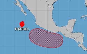
Taking a look at today's runs that do show development potential in the western Gulf, most only support a weaker and quicker storm, which makes sense with forecasts of ongoing high levels of shear. One caveat to the shear forecast, is that a good deal of the shear models see during this otherwise so-so window is a result of and possibly contingent on the development of yet another far east Pac tropical cyclone (as seen below shown to be an 80% region to the southeast of Hurricane Rachel in the NHC TWO)


Should the Area of Interest presently southeast of Rachel not track close to mainland Mexico as forecast, shear across the Gulf could be less. Another wild card would be for this AOI to cross over into the BOC. A few models and/or ensembles suggest either as possible.

Some quick glances at a few of today's Globals

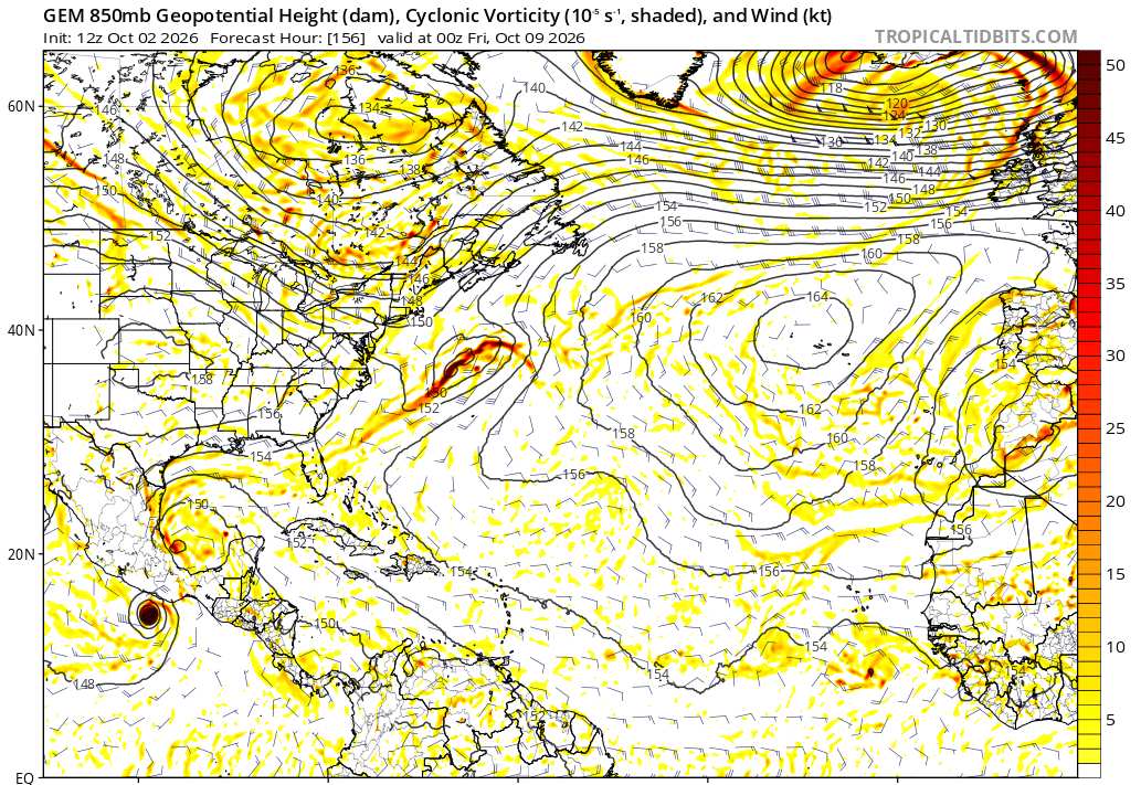
CANADIAN out to 156 hours advertising development on both sides of Central America (the previously noted AOI in the east Pac as well as a new disturbance in the BoC)


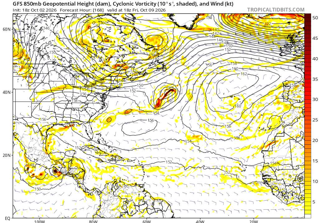
GFS takes the east Pac AOI itself across the Isthmus of Tehuantepec and creates a trof in the western Gulf, but without much development there. Rain-maker for east TX.


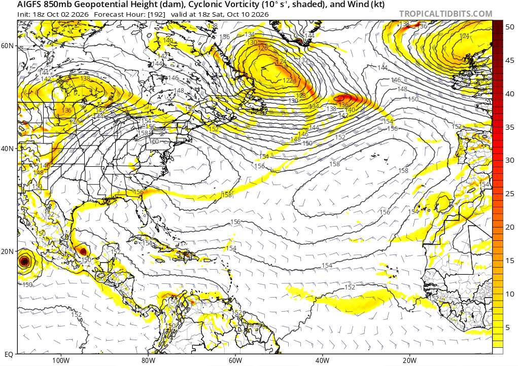
The AI GFS makes like the Canadian and spawns two systems on either side of Central America, but the Gulf feature is kept weak, short-lived and runs into Mexico.


The window is still open, but this is a window with a lot of doubts, and if anything does form, unlike a lot of the hype seen in social media, odds are really that it would be weak and/or short-lived, with only an outlier chance of a strong cyclone (maybe at best 10-15% of something below 995mb IMHO)

Post Extras Print Post   Remind Me!     Notify Moderator


Entire topic
Subject Posted by Posted on
* W Carib-Gulf Window Oct 6-14 Invest TBD cieldumortModerator Fri Oct 02 2026 11:37 PM
. * * Re: W Carib-Gulf Window Oct 6-14 Invest TBD cieldumortModerator   Sat Oct 03 2026 02:20 PM
. * * Re: W Carib-Gulf Window Oct 6-14 Invest TBD cieldumortModerator   Sat Oct 03 2026 03:49 AM
. * * Re: W Carib-Gulf Window Oct 6-14 Invest TBD cieldumortModerator   Fri Oct 02 2026 11:37 PM
. * * Re: W Carib-Gulf Window Oct 6-14 Invest TBD cieldumortModerator   Fri Oct 02 2026 03:04 AM
. * * Re: W Carib-Gulf Window Oct 6-14 Invest TBD cieldumortModerator   Wed Sep 30 2026 09:12 AM

Extra information
0 registered and 0 anonymous users are browsing this forum.

Moderator:  CFHC, MikeC, Ed Dunham, Colleen A., Atricks, danielw, Clark, Christine H, RedingtonBeachGuy, SkeetoBite, Bloodstar, tpratch, typhoon_tip, cieldumort, Jackie M, Wigeon, Hank Buck 


Forum Permissions
      You cannot start new topics
      You cannot reply to topics
      HTML is disabled
      UBBCode is enabled

Rating:
Thread views: 654

Rate this thread

Jump to