Current Radar or Satellite Image

Flhurricane.com - Central Florida Hurricane Center - Tracking Storms since 199531 Years of Hurricanes Without the Hype - Since 1995


Atlantic is quiet as the El Niño fueled Pacific continues firing on all cylinders, but an NHC Lemon may be on the way for SW Gulf.
Days since last Hurricane Landfall — US Any: 723 (Milton), US Major: 723 (Milton), FL Any: 723 (Milton), FL Major: 723 (Milton)
FlHurricane Atlantic Tropical Cyclone Tracking 🌀 Since 1995
None
HypeScale:
0.10
0510
Communication
Storm Data
Content
Follow & Connect


General Discussion >> 2026 Forecast Lounge

cieldumortModerator
Moderator


Reged:
Posts: 2900
Loc: Austin, Tx
Re: W Carib-Gulf Window Oct 6-14 Invest TBD
      Sat Oct 03 2026 03:49 AM

This is an incredibly tricky season for both models and forecasters alike where the Atlantic basin is concerned. The one safe bet all season would have been, has been, should have been, "Nothing becomes a hurricane." Fay and possibly Edouard got close, but no cigar*. With this backdrop, the rational thing to do is ignore any model runs that ramp up this yet-to-form system in the Gulf beyond 60 MPH unless and until something is getting obvious.

The most recent suite of 0z Globals during this window.

Quick Globals rundown:

EURO - Sloppy Trof; borderline TD at times by 10/11/06z in northern Gulf
EURO AI - Weak Tropical Low by 10/11/0z in northwestern Gulf
GFS - TD or Low-end Trop Storm by 10/12/06z in northwestern Gulf
GFS AI - TD by 10/11/0z in the southwestern Gulf. Quickly makes landfall in western BoC mainland MX.
ICON - Borderline TD by 10/10/06z in the northern Gulf.
UKMET - Apparent TD or weak Trop Storm in the southwestern Gulf by 10/07/21z. Making landfall around Cape San Blas, Gulf County, 10/10/0z 989mb.

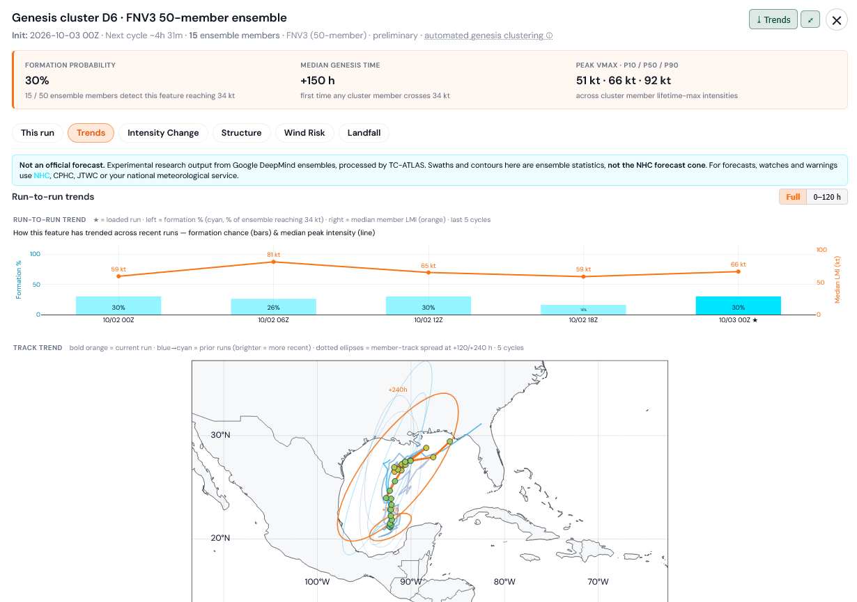
As for the Google DeepMind FNv3 ensembles, after a dip with their 18z run, the most recent 0z came back in implying a 30% chance of this becoming a Tropical Storm


Credits: TC-ATLAS and Google


*Both Fay and Edouard were likely stronger than operational advisories had them and one or both could easily be upgraded during reanalysis. Only referring to real-time NHC Advisories.

Post Extras Print Post   Remind Me!     Notify Moderator


Entire topic
Subject Posted by Posted on
* W Carib-Gulf Window Oct 6-14 Invest TBD cieldumortModerator Sat Oct 03 2026 03:49 AM
. * * Re: W Carib-Gulf Window Oct 6-14 Invest TBD cieldumortModerator   Sat Oct 03 2026 02:20 PM
. * * Re: W Carib-Gulf Window Oct 6-14 Invest TBD cieldumortModerator   Sat Oct 03 2026 03:49 AM
. * * Re: W Carib-Gulf Window Oct 6-14 Invest TBD cieldumortModerator   Fri Oct 02 2026 11:37 PM
. * * Re: W Carib-Gulf Window Oct 6-14 Invest TBD cieldumortModerator   Fri Oct 02 2026 03:04 AM
. * * Re: W Carib-Gulf Window Oct 6-14 Invest TBD cieldumortModerator   Wed Sep 30 2026 09:12 AM

Extra information
0 registered and 0 anonymous users are browsing this forum.

Moderator:  CFHC, MikeC, Ed Dunham, Colleen A., Atricks, danielw, Clark, Christine H, RedingtonBeachGuy, SkeetoBite, Bloodstar, tpratch, typhoon_tip, cieldumort, Jackie M, Wigeon, Hank Buck 


Forum Permissions
      You cannot start new topics
      You cannot reply to topics
      HTML is disabled
      UBBCode is enabled

Rating:
Thread views: 653

Rate this thread

Jump to