Current Radar or Satellite Image

Flhurricane.com - Central Florida Hurricane Center - Tracking Storms since 199531 Years of Hurricanes Without the Hype - Since 1995


EPAC systems again to bring more rain to SW US. Atlantic is back to El Niño status quo.
Days since last Hurricane Landfall — US Any: 5 (Isaias), US Major: 735 (Milton), FL Any: 5 (Isaias), FL Major: 735 (Milton)
FlHurricane Atlantic Tropical Cyclone Tracking 🌀 Since 1995
None
HypeScale:
0.50
0510
Communication
Storm Data
Content
Follow & Connect


General Discussion >> 2026 Forecast Lounge

cieldumortModerator
Moderator


Reged:
Posts: 2935
Loc: Austin, Tx
Re: Hybrid system late October east of Florida/north of Bahamas?
      Thu Oct 15 2026 01:53 AM

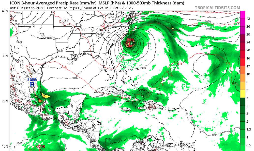
The most recent ICON run (15/0z) which this model sometimes sniffs out future development where other models miss earlier on, is definitely on board with the general idea, albeit perhaps a bit further north.

So, remarkably, despite the headwinds coming out of the eastern Pacific, the overall state of the Atlantic basin is one I wouldn't write off the rest of this month. Gulf stream probably bears some monitoring.


Post Extras Print Post   Remind Me!     Notify Moderator


Entire topic
Subject Posted by Posted on
* Hybrid system late October east of Florida/north of Bahamas? IsoFlame Thu Oct 15 2026 01:53 AM
. * * Re: Hybrid system late October east of Florida/north of Bahamas? cieldumortModerator   Thu Oct 15 2026 01:53 AM

Extra information
0 registered and 0 anonymous users are browsing this forum.

Moderator:  CFHC, MikeC, Ed Dunham, Colleen A., Atricks, danielw, Clark, Christine H, RedingtonBeachGuy, SkeetoBite, Bloodstar, tpratch, typhoon_tip, cieldumort, Jackie M, Wigeon, Hank Buck 


Forum Permissions
      You cannot start new topics
      You cannot reply to topics
      HTML is disabled
      UBBCode is enabled

Rating:
Thread views: 238

Rate this thread

Jump to