Current Radar or Satellite Image

Flhurricane.com - Central Florida Hurricane Center - Tracking Storms since 199531 Years of Hurricanes Without the Hype - Since 1995


Monitoring Invest 93L off the east coast, likely fish storm, but still some coastal impacts (dangerous surf, costal flooding).
Days since last Hurricane Landfall — US Any: 10 (Isaias), US Major: 740 (Milton), FL Any: 10 (Isaias), FL Major: 740 (Milton)
FlHurricane Atlantic Tropical Cyclone Tracking 🌀 Since 1995
HypeScale:
1.45
0510
Communication
Storm Data
Content
Follow & Connect


General Discussion >> 2026 Forecast Lounge

cieldumortModerator
Moderator


Reged:
Posts: 2944
Loc: Austin, Tx
Re: 93L Lounge
      Tue Oct 20 2026 01:41 AM


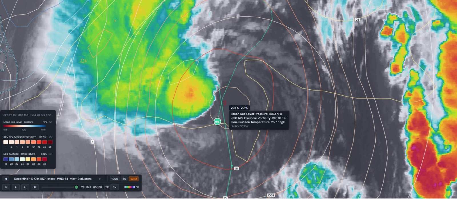
93L 10-20-26-05z MSLP 850 hPa Vorticity SST analysis overlay atop IR. Image credits: TC-ATLAS

The cyclone is trying, but relatively cool SSTs as well as some shear are clearly challenging the attempted transition, so far

Post Extras Print Post   Remind Me!     Notify Moderator


Entire topic
Subject Posted by Posted on
* 93L Lounge cieldumortModerator Tue Oct 20 2026 01:41 AM
. * * Re: 93L Lounge cieldumortModerator   Tue Oct 20 2026 01:41 AM
. * * Re: 93L Lounge cieldumortModerator   Tue Oct 20 2026 01:50 AM
. * * Re: Gulf Stream Coastal Low w Tropical Potential cieldumortModerator   Sun Oct 18 2026 03:30 PM
. * * Re: Gulf Stream Coastal Low w Tropical Potential cieldumortModerator   Sat Oct 17 2026 06:46 PM

Extra information
0 registered and 0 anonymous users are browsing this forum.

Moderator:  CFHC, MikeC, Ed Dunham, Colleen A., Atricks, danielw, Clark, Christine H, RedingtonBeachGuy, SkeetoBite, Bloodstar, tpratch, typhoon_tip, cieldumort, Jackie M, Wigeon, Hank Buck 


Forum Permissions
      You cannot start new topics
      You cannot reply to topics
      HTML is disabled
      UBBCode is enabled

Rating:
Thread views: 371

Rate this thread

Jump to