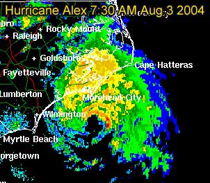
8AM Windspeed increased to 90MPH. Pressure dropping. Still looks like it will skirt the coastline and never truly make landfall, but it's splitting hairs at that level.
Original Update: Alex overnight has become this year's first Hurricane of the season, with maximum sustained winds as of 5AM at 80MPH.
It's current movement to the northeast this morning puts it very close to the North Carolina coastline, but looks like the eye will not make landfall. It's currently moving nearly parallel to the coastline. One caveat, a slight jog to the left could put it over briefly. And it's close enough to the outer banks for it to feel quite a bit of this storm.
Best of luck to to folks in North Carolina, as a good chunk of the rain shield is over the coastline now. And I suspect a few parts of the outer banks will get hurricane force winds, even if the eyewall doesn't pass over. We'll be watching all day.
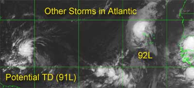
The other storms in the Atlantic still have the potential to form, and folks in the eastern Caribbean (lesser antilles) will want to watch, because it has a chance to strengthen and get close.


 Flat
Flat