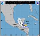
Invest 90L is currently located in the northwest Caribbean Sea, just north of the coast of Honduras. A broad area of low pressure accompanies the system, with a sizable band of convection located to its east between it and Jamaica. The system moved offshore early this morning, with a minimum sea level pressure of 1004mb (per NHC) and maximum winds estimated at around 25kt (per QuikSCAT) in isolated regions around the center. Microwave satellite imagery hints at a small area of convection near the center, perhaps indicating some tightening of the circulation to come. The Hurricane Hunters will be heading out to the system early this afternoon and should provide some confirmation of what appears to be there from the satellite imagery & satellite-derived data, though I think it's not at depression stage yet.
The upper-level pattern remains relatively unchanged from this time yesterday, albeit with some subtle differences. A trough is still located to the west of the system -- and has actually moved a little south lately -- but has narrowed in scope considerably over the past two days. Small, weak systems continue to move around it, with a larger impulse in the N. Gulf south of New Orleans. To its west, winds are strong along the interface between the trough and the E. Pacific subtropical ridge; where this core of winds goes, south or around the trough, will largely determine the short-term evolution of the system. As HF noted on the boards, development slower than the models are forecasting is probably a good bet. As several have noted, a slightly lopsided appearance may be in the offings for this storm, at least at its onset. Winds to the north and east of the tropical disturbance have lessened and continue to do so as the ridge builds in, as forecast by the globals. If the East Pacific ridge builds in and wins the battle, the storm may get sheared apart before it even gets going; right now, though, I don't see that as terribly likely.
Key factors: wind shear (initial system evolution & strength), position & intensity of the building ridge (track), and the track of the storm in the Gulf itself (intensity). Waters in the Gulf are warm, but the greatest amount of energy & greatest depth of warm waters is in the central Gulf. A storm that heads towards the Fl. Panhandle is likely not going to be as strong of a storm as one that heads towards Louisiana solely off of water temperatures. In either case, I don't see anything that develops getting all that strong, due to climatological factors as well as the overall pattern we're in right now. At this rate, I do see something developing in the NW Caribbean and heading into the Gulf as a tropical storm in 2-3 days; what it does from there is anyone's guess right now and entirely dependent upon the ridge that is forecast to build in across the east coast. We could have a depression the whole way, or we could have something more; it's tough to really say right now.
Stay tuned over the coming week for more on this evolving situation. Everyone along the northern and eastern Gulf coast needs to watch this one closely for the 3-5 day time frame.
Edited by MikeC (Wed Jun 08 2005 12:15 PM)
|


 Flat
Flat


