CFHC

Reged:
Posts: 152
Loc: East Central Florida
|
 Now to Kyle And Lili
Fri Sep 27 2002 04:59 AM
|
|
|
What an amazing track Isidore was.... first getting a run in with South America it pulled north a bit to enter the Western Caribbean. Was it planned to be a problem for Jamaica or Cuba at the time? No, but it flooded Jamaica and grazed the western part of Cuba. Now it was to move west... right?
Projections had it to go west then loop in the gulf and head north, rightly so many along the Gulf coast started to watch Isidore like a hawk. A few models hinted at a southerly jog first, but not into the Yucatan. Category 3 almost a 4, oops Isidore slides south into the hurricane warning area causing much pain to the North Yucatan coastline in Mexico. This rather impressive storm collapsed over the Yucatan, but it was so big the energy was disbursed, after it eventually moved back over the water it was unable to do anything more than hold its own... almost in a way that parts of the system were non tropical and others were.... Causing rain even to Florida it dumped copious amounts of rain along the coast and caused a minor storm surge in the New Orleans area...
To those who think Isidore was a bust, be glad, the alternative of a category 3 or 4 hitting New Orleans is not pretty. Much like Hurricane Bret a few years ago hitting in an unpopulated area in Texas, this one managed to avert a real catastrophe. Our intent here is not to want storms like this to hit, but to provide information to help determine what is going on. The interest level is higher amongst people when a major is in the Gulf, the numbers prove it, for reason... It could affect many people. The entire time I wanted it to fall apart and was looking for ways for it to happen. The Yucatan landfall wasn't it for me. Mexico sure did not need it. The rather light hit on New Orleans may be a slight wakeup call for them, though, and if that's the case then that would be the good side to it.
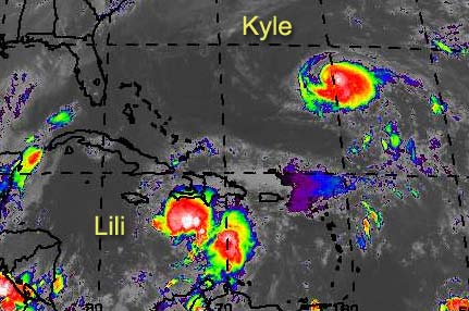
Lili will follow fairly closely Isidore's previous path near Jamaica and Cuba, and after that I'm not able to say yet, but of course again we must all watch it. There are Tropical Storm watches up now for Jamaica.
Kyle is backing down fairly far south and believe it or not we still may have to watch this one along the Eastern Seaboard. Models differ some one to loop it around and back northeast, others like the AVN pull it southeast even more.
NRL Monterey Marine Meteorology Division Forecast Track of Active Systems (Good Forecast Track Graphic and Satellite Photos)
NASA GHCC Interactive Satellite images at:
North Atlantic Visible (Daytime Only), Infrared, Water Vapor
Some forecast models:
NGM, AVN, MRF, ETA ECMWF
DoD Weather Models (NOGAPS, AVN, MRF)
AVN, ECMWF, GFDL, MM5, NOGAPS, UKMET
Multi-model plots from WREL
Other commentary at Mike Anderson's East Coast Tropical Weather Center, Robert Lightbown/Crown Weather Tropical Update Accuweather's Joe Bastardi, Hurricane City Weather Audio Broadcast Network - Live Audio from Jim Williams and Barometer Bob , mpittweather , Tropical Weather Watchers.Com (JasonM) Gary Gray's Millennium Weather, Barometer Bob's Hurricane Hollow, Snonut, Ed Dunham and Jason M in our Storm Forum Even more on the links page.
- [mac]
|
|


 Flat
Flat


