Current Radar or Satellite Image

Flhurricane.com - Central Florida Hurricane Center - Tracking Storms since 199531 Years of Hurricanes Without the Hype - Since 1995


Nothing near term in the Atlantic now as Post-SubTropical Josephine heads out to sea.
Days since last Hurricane Landfall — US Any: 16 (Isaias), US Major: 746 (Milton), FL Any: 16 (Isaias), FL Major: 746 (Milton)
FlHurricane Atlantic Tropical Cyclone Tracking 🌀 Since 1995
None
HypeScale:
0.05
0510
Communication
Storm Data
Content
Follow & Connect


News Talkback >> 2005 Storm Forum

Ed DunhamAdministrator
Former Meteorologist & CFHC Forum Moderator (Ed Passed Away on May 14, 2017)


Reged:
Posts: 2565
Loc: Melbourne, FL
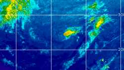
Area of Interest - Southern Bahamas
      Sat Sep 10 2005 06:38 PM

Stationary open tropical wave with active convection extending northward from the southern Bahamas. Some hint of a weak mid-level circulation or turning near 22.7N 74.0W at 10/22Z. System is under moderate northerly shear so development, if any, will be slow.
ED
Post Extras Print Post   Remind Me!     Notify Moderator


Entire topic
Subject Posted by Posted on
* Area of Interest - Southern Bahamas Ed DunhamAdministrator Sat Sep 10 2005 06:38 PM

Extra information
0 registered and 0 anonymous users are browsing this forum.

Moderator:  MikeC, Ed Dunham, danielw 


Forum Permissions
      You cannot start new topics
      You cannot reply to topics
      HTML is disabled
      UBBCode is enabled

Rating:
Thread views: 5221

Rate this thread

Jump to