New Article: CSU releases 2026 season numbers, slightly below average. https://flhurricane.com
Days since last Hurricane Landfall —
US Any:
557 (Milton),
US Major:
557 (Milton),
FL Any:
557 (Milton),
FL Major:
557 (Milton)
Weather456
Verified CFHC User
Reged:
Posts: 14
|
 Last Week of July Tropics as 99L Becomes Better Organized
Thu Jul 27 2006 09:12 AM
|
|
|
The area of disturbed weather that brought heavy rain to southeastern Texas and parts of Louisiana on Wednesday is now well inland. Moisture from this system will feed more showers and thunderstorms today through the southern Plains.
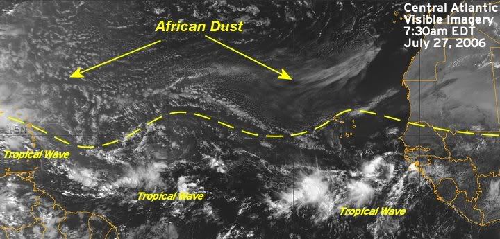
There are tropical waves along 35 west, south of 15 north, along 46 west, south of 22 north, along 67 west, south of 24 north and along 84 west, south of 20 north. All waves with the exception of the wave along 64 west are moving west at about 6-7 degrees longitude per day.
The wave along 67 west is moving west at 8-10 degrees longitude per day as it starts to interact with the Atlantic high to the north. This high is producing a stronger pressure gradient over the Greater Antilles. This wave will bring the eastern and northeastern Caribbean a few showers and thunderstorms, but it is moving too fast to bring any prolonged rainfall. A large mass of African Dust showing up on both the United States and European satellite images of the Atlantic is causing any showers and thunderstorms with this wave to diminish quickly. This wave will bring showers into the southern Bahamas and Hispaniola tomorrow and tomorrow night, then might enhance shower and thunderstorm development over the northern Bahamas and perhaps into southeastern Florida, Friday night into Saturday morning.
99L
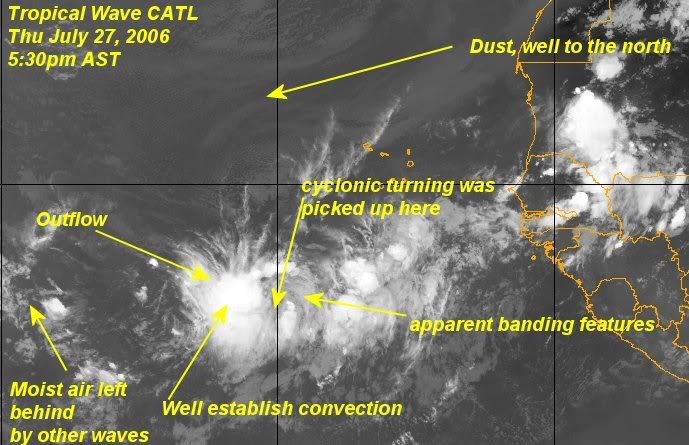
A tropical wave, located about midway across the Atlantic, is beginning to show signs of some development. This wave is associated with a weak surface low pressure which is helping to maintain associated thunderstorms as it moves east. Additionally, upper level winds are forecast to slowly become more favorable in areas out ahead of this wave. It is possible that tropical development could occur with this wave in the next day or so. It will continue to be monitored closely.

Figure 1: 99L Invest

Fugure 2: Central Atlantic Visisble Imagery
Edited by Weather456 (Fri Jul 28 2006 08:18 AM)
|
|
 Last Week of July Tropics as 99L Becomes Better Organized
|
Weather456
|
Thu Jul 27 2006 09:12 AM
|
|
0 registered and 38 anonymous users are browsing this forum.
Moderator:
|
Forum Permissions
You cannot start new topics
You cannot reply to topics
HTML is disabled
UBBCode is enabled
|
Rating:
Thread views: 4198
|
|
|
|
|
|
Note: This is
NOT an official page. It is run by weather hobbyists and should not be used as a replacement for official sources.
CFHC's main servers are currently located at
Hostdime.com in Orlando, FL.
Image Server Network thanks to Mike Potts and Amazon Web Services. If you have static file hosting space that allows dns aliasing contact us to help out! Some Maps Provided by:
Great thanks to all who
donated and everyone who uses the site as well.
Site designed for 800x600+ resolution
When in doubt, take the word of the
National Hurricane Center
G