
Tropical Storm Arthur
Posted: 10:54 AM 17 June 2026 | 4 Comments | Add Comment | Newest: 04:44 PM 17-Jun EDT
The Tropical Storm Warning has been extended along the upper Texas coastline.
Tropical Storm Arthur Special Advisory Number 6
NWS National Hurricane Center Miami FL AL012026
1130 AM CDT Wed Jun 17 2026
...TROPICAL STORM WARNING EXTENDED SOUTHWARD...
...LIFE-THREATENING FLOODING EXPECTED ACROSS PORTIONS OF THE
SOUTHEASTERN UNITED STATES...
SUMMARY OF 1130 AM CDT...1630 UTC...INFORMATION
-----------------------------------------------
LOCATION...28.8N 95.5W
ABOUT 60 MI...100 KM ENE OF PORT OCONNOR TEXAS
ABOUT 165 MI...265 KM WSW OF LAKE CHARLES LOUISIANA
MAXIMUM SUSTAINED WINDS...45 MPH...75 KM/H
PRESENT MOVEMENT...NE OR 45 DEGREES AT 9 MPH...15 KM/H
MINIMUM CENTRAL PRESSURE...999 MB...29.50 INCHES
WATCHES AND WARNINGS
--------------------
CHANGES WITH THIS ADVISORY:
The Tropical Storm Warning has been extended southward to Sargent,
Texas.
SUMMARY OF WATCHES AND WARNINGS IN EFFECT:
A Tropical Storm Warning is in effect for...
* Sargent, Texas to Morgan City, Louisiana
10AM CDT 17 June, 2026 Update
Recon has confirmed that ONE has become our first Tropical Storm of the year and NHC Advisories are being initiated on Arthur.
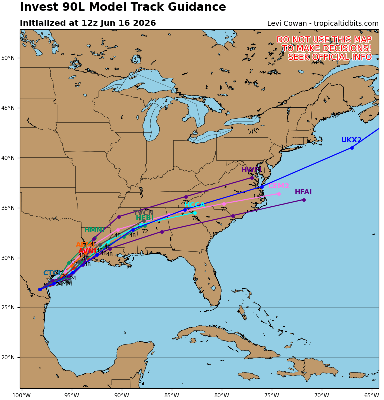
Model deep-dives and more in the Arthur Forecast Lounge
Tropical Storm Arthur Event Related Links
Tropical Tidbits Page on system
Flhurricane Satellite Floater Animation of 1
GOES Floater
Tomer Berg Info page for 1
CyclonicWx Page for 1
Clark Evans Track Model Plot of 1
(Animated!) Model Plots in Google Earth - In Google Maps
Clark Evans Intensity Model Plot of 1 (Animated!)
Clark Evans Top 10 Analog Storms for 1
http://www.ral.ucar.edu/guidance/realtime/current/ More model runs on from RAL/Jonathan Vigh's page
NRL Info on 1 -- RAMMB Info
COD Atlantic Satellite View
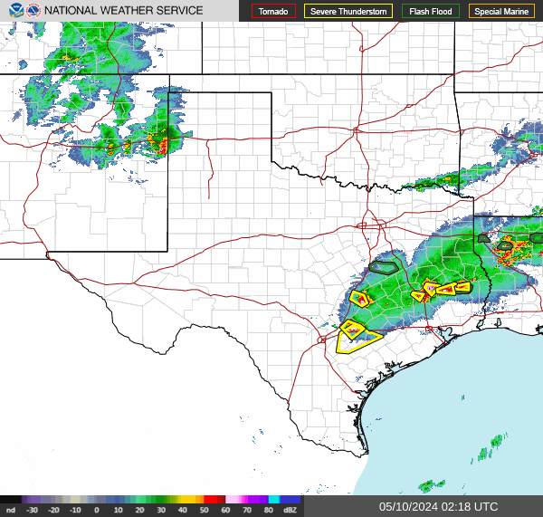
Texas Gulf Coast Links [http://moe.met.fsu.edu/~mnissenbaum/radar.html Mark Nissenbaum's radar page}
Texas Composite Radar Loop (Latest Static) East to West:
Houston/Galveston, TX Radar Radar Loop (Latest Static)
Corpus Christi, TX Radar Radar Loop (Latest Static)
Brownsville, TX Radar Radar Loop (Latest Static)
Gulf of Mexico Satellite Imagery
Area Forecast Discussions: Houston/Galveston, TX - Corpus Christi, TX - Browsnville/South Padre Island, TX
Potential Tropical Cyclone One Issued Near Texas Gulf Coast
Posted: 10:50 AM 10 June 2026 | 2 Comments | Add Comment | Newest: 11:51 AM 15-Jun EDT
PTC ONE is producing sustained winds into tropical storm force based on buoy, ship and oil rig reports. Recon is now flying in. The cyclone at this time resembles a sheared tropical storm and it would not be surprising if we have Arthur at 10AM.
Ciel
4:00AM CDT 17June, 2026 Update
PTC ONE is a highly-sheared cyclone this morning, and too void of convection near and over the center for it to be classified as a Tropical Cyclone. However, with PTC ONE, as has been mentioned here, there and everywhere, the classification isn't what matters, but rather the impacts.
Quote:
Quote:
KEY MESSAGES:
Quote:
Quote:
1. Potentially life-threatening flash flooding and urban flooding are likely through Thursday across southern Louisiana, southern Mississippi, southern Alabama, southwestern Georgia and the Florida Panhandle, with possible flooding near the Upper Texas coast. Ongoing heavy rainfall could prolong the flood threat into the weekend.
Quote:
Quote:
2. Tropical-storm-force winds are expected along the Louisiana coast today from Sabine Pass to Morgan City where a Tropical Storm Warning is in effect.
Quote:
Quote:
3. Minor to moderate coastal flooding is expected along portions of the Upper Texas and Louisiana coastlines today.
Quote:
Quote:
FORECAST POSITIONS AND MAX WINDS
Quote:
Quote:
INIT 17/0900Z 28.0N 96.7W 25 KT 30 MPH...POTENTIAL TROP CYCLONE
Quote:
12H 17/1800Z 29.1N 95.2W 35 KT 40 MPH...TROPICAL STORM
Quote:
24H 18/0600Z 31.1N 92.8W 25 KT 30 MPH...POST-TROP/REMNT LOW
Quote:
36H 18/1800Z...DISSIPATED
Ciel
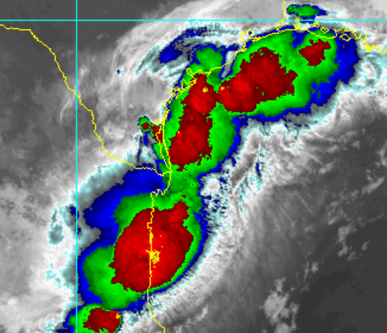
4:00PM CDT 16 June, 2026 Update
PTC ONE is already on the cusp of being classifiable as a Tropical Depression and may go straight to being a named Tropical Storm within minutes or hours after moving offshore. A Tropical Storm Warning is now up for the coast of Louisiana from Sabine Pass to Morgan City. There are a few models that increasingly suggest likely-Arthur may have a chance to strengthen a little more than forecast, so mariners and those along the coast may want to take note. Additionally, interactions with strong jet dynamics and a very large area of "brown ocean" (very saturated land and a humid atmosphere) could keep likely-Arthur going - perhaps even intensifying - over land. This is a very dangerous storm.
Quote:
NWS National Hurricane Center Miami FL AL012026 400 PM CDT Tue Jun 16 2026 ...DANGEROUS FLASH FLOODING CONTINUES OVER PORTIONS OF TEXAS AND LOUISIANA FROM POTENTIAL TROPICAL CYCLONE ONE.... ...TROPICAL STORM WARNING ISSUED FOR PORTIONS OF THE LOUISIANA COAST.. SUMMARY OF 400 PM CDT...2100 UTC...INFORMATION ----------------------------------------------LOCATION...27.3N 97.6W ABOUT 35 MI...60 KM SSW OF CORPUS CHRISTI TEXAS ABOUT 330 MI...530 KM SW OF LAKE CHARLES LOUISIANA MAXIMUM SUSTAINED WINDS...30 MPH...45 KM/H[ PRESENT MOVEMENT...NE OR 45 DEGREES AT 6 MPH...9 KM/H MINIMUM CENTRAL PRESSURE...1005 MB...29.68 INCHES WATCHES AND WARNINGS--------------------CHANGES WITH THIS ADVISORY:A Tropical Storm Warning is issued for the coast of Louisiana from Sabine Pass to Morgan City. SUMMARY OF WATCHES AND WARNINGS IN EFFECT: A Tropical Storm Warning is in effect for...* Sabine Pass to Morgan Cit A Tropical Storm Watch is in effect for... * Sargent to Sabine Pass
Ciel
9:30AM CDT 16 June, 2026 Update
NHC will initiate advisories on Potential Tropical Cyclone One (formerly AL90) located over southern Texas, at 1000 AM CDT (1500 UTC).
8:00AM CDT 16 June, 2026 Update
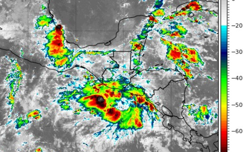
Invest 90L is over land and still has a 60% chance to develop. The energy is stretched out along the front, but the best track position has it located there northwest of Brownsville near Encino, TX. This area has a chance to develop once it reaches the water, but anything that does (if it does) is likely to be short lived. The impact remains heavy, flooding rainfall.
1:40PM CDT 15 June, 2026 Update
The Area of Interest has just been Invest-tagged, 90L. Specialized model runs will begin shortly and recon is being tentatively scheduled.
Ciel
1:00PM CDT 15 June, 2026 Update
Chances for development of this system are up to 50%, and Tropical Storm Watches and Warnings could be issued as early as tomorrow for portions of the NW Gulf.
12:00PM CDT 15 June, 2026 Update
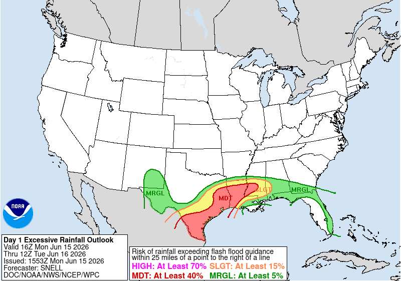
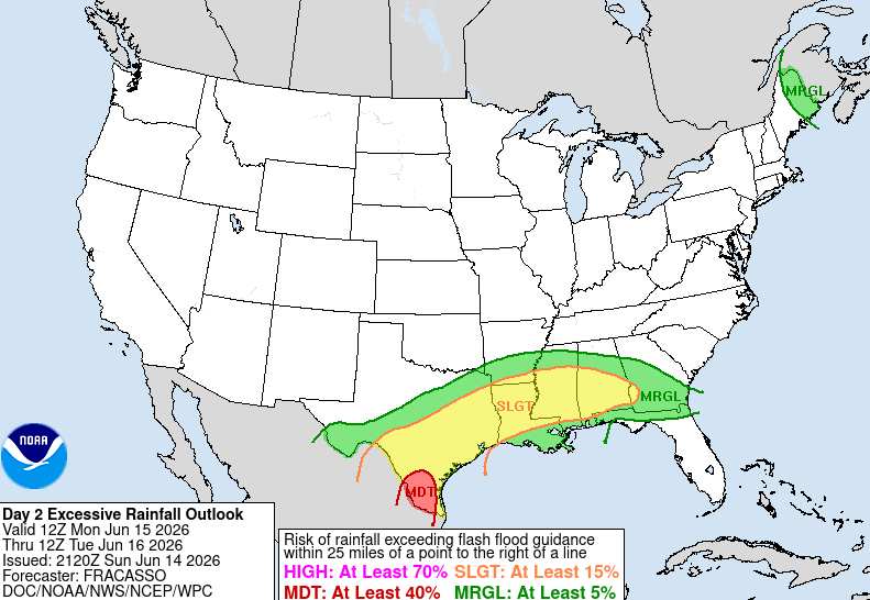
Widespread flash flooding, some of it catastrophic, continues. WPC has greatly expanded the MODERATE RISK outline
4:45PM CDT 14 June, 2026 Update
The risk of Flash Flooding across the south is going way up in response to the abundant influx of deep, tropical moisture courtesy of the area of low pressure we have been tracking and which is now inland over northeastern Mexico feeding into and interacting with an approaching wind shift front that is forecast to pull up mostly stationary for several days. Ground will likely become saturated if it isn't already across portions of south Texas, southeast Texas and Louisiana, and a multi-day, life-threatening flood event may be setting up.
Ciel
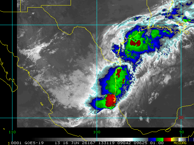
10:00AM CDT 13 June, 2026 Update
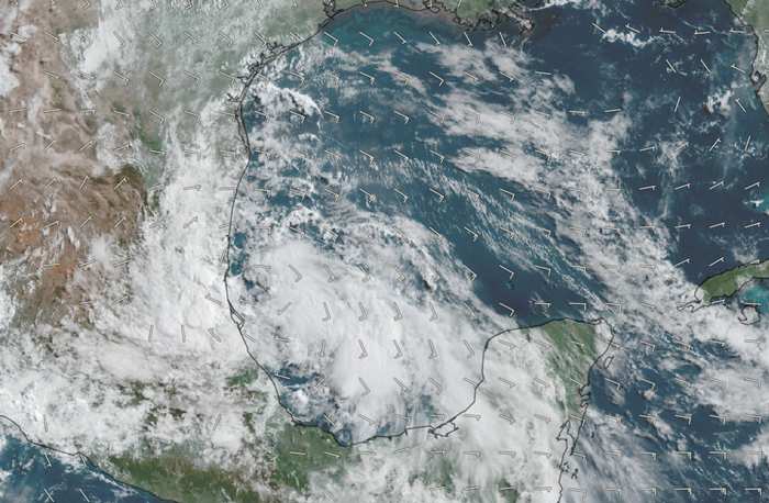
Above: This morning's visible image of the Gulf Low overlaid with GFS-analyzed 10-meter winds cr. TC-ATLAS
The Low in the western Gulf continues to gradually become better organized and is now likely centered just east of Tampico, MX, heading generally NW to NNW. Fluctuations in its path are likely over the next 3-7 days, but it is mostly modeled to head inland and then either track just inland from the coast of Texas, bumping into an approaching front, or reemerge off the coast roughly east of Brownsville, TX early next week.
The greatest risk with the area of low pressure in the western Gulf is going to be from the potential for several days of tropical rainfall and flooding, regardless of whether or not it becomes a Tropical Depression. The same will be true should it become a Tropical Depression, but never get a name. This is a system that is cranking up loads and loads of moisture into eastern Mexico, Texas and Louisiana, is likely to get stuck underneath a stalling front, and then get wrung out over the course of 3-7 days over many of the same areas. Flooding is always a serious risk with 'weak' systems that slow down or stall, but unfortunately, all-too-often these systems do not get the attention they deserve because they lack a name or title.
-Ciel
7:45AM CDT 12 June, 2026 Update
An area of low pressure has indeed formed in the Bay of Campeche. This is a very favorable region for Tropical Cyclogenesis and despite less-than-ideal conditions for development, development is possible and in fact the odds appear to be going up. An Invest tag is likely coming, specialized model runs would be added, and perhaps recon will also be tasked, depending.
-Ciel
Original Update
The 8am update for the tropical weather outlook now has the first area of interest for the 2026 Atlantic Hurricane season. This area would be the remnants of Cristina in the East Pacific after it crosses Guatemala and Mexico, which has a lot of high mountains. It's overall unlikely to develop, but worth watching in those areas and later on in the Gulf side of Mexico, and rainfall could reach its way into Texas after this. It'll be monitored for mid to late next week, but at this time development chances appear to be very low.

The remnants of east pacific Cristina with some tropical storm warnings up along Guatemala and El Salvador now:
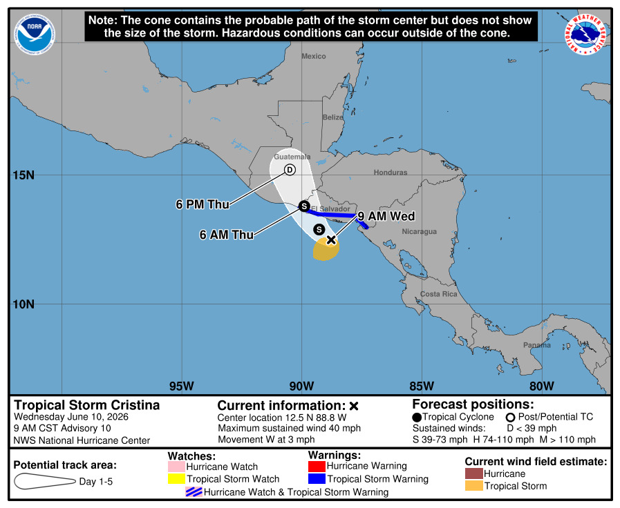
Forecast Lounge discussion for this system in https://flhurricane.com/cyclone/showflat...gonew=1#UNREAD
Potential Tropical Cyclone One Event Related Links
Tropical Tidbits Page on system
Flhurricane Satellite Floater Animation of 1
GOES Floater
Tomer Berg Info page for 1
CyclonicWx Page for 1
Clark Evans Track Model Plot of 1
(Animated!) Model Plots in Google Earth - In Google Maps
Clark Evans Intensity Model Plot of 1 (Animated!)
Clark Evans Top 10 Analog Storms for 1
http://www.ral.ucar.edu/guidance/realtime/current/ More model runs on from RAL/Jonathan Vigh's page
NRL Info on 1 -- RAMMB Info
COD Atlantic Satellite View
Texas Gulf Coast Links [http://moe.met.fsu.edu/~mnissenbaum/radar.html Mark Nissenbaum's radar page}
Texas Composite Radar Loop (Latest Static) East to West:
Houston/Galveston, TX Radar Radar Loop (Latest Static)
Corpus Christi, TX Radar Radar Loop (Latest Static)
Brownsville, TX Radar Radar Loop (Latest Static)
Gulf of Mexico Satellite Imagery
Area Forecast Discussions: Houston/Galveston, TX - Corpus Christi, TX - Browsnville/South Padre Island, TX
The 2026 Atlantic Hurricane Season Begins Today
Posted: 06:43 AM 01 June 2026 | 2 Comments | Add Comment | Newest: 08:24 PM 02-Jun EDT
This year is expected to be lower than average because of the el nino effect. This is basically a periodic event in the Pacific ocean that warms up temperatures there in the eastern Pacific, which tends to lower pressure there, and force trade winds to be stronger over the Atlantic, as well as the mid Atlantic back feed, which causes windshear and more stability in the atmosphere in general in the Atlantic, which dampens the hurricane season. However, it does not prevent it, some notable storms like hurricane Andrew happened in an El Nino year. So it's important to watch. It does favor storms doing odd tracks and patterns where it typically won't form as far out, for those that form.
In the near term although there is some moisture, there's nothing organized in the Atlantic that looks like it could develop in the next week or two. But the areas typically to watch this time of year are off the southeast coast and Gulf. Have a plan in place if you live in an evacuation area, and get be prepared now, not when a storm is bearing down on you.
Another year here 31st year for flhurricane.com. With some new features like the hurricane radar page on the left, focusing on Atlantic coastal hurricane radars (and Hawaii). We've also made it easier to share graphics like models, satellites and radar in the posts, just upload or even copy paste images into the forums this year, and crop/resize them right on the site.
Names for this year:
| Arthur | Hanna | Omar |
| Bertha | Isaias | Paulette |
| Cristobal | Josephine | Rene |
| Dolly | Kyle |
Sally |
| Edouard | Leah |
Teddy |
| Fay | Marco | Vicky |
| Gonzalo | Nana | Wilfred |
The National Hurricane center is the official source for advisories, warnings, and more, use https://nhc.noaa.gov for the best information. floridadisaster.org for emergency information in Florida. And local media (Tv, radio, papers, etc) for the best information for your particular area if the need arises.
Flhurricane stays away from hype and engagement farming, we do have social media on X and facebook, that we update when necessary. Posting long range modeling runs without context on the main site/socials is something we actively avoid since this we think is generally unhelpful and just causes confusion to highlight them. However, it doesn't mean they are not discussed, for those interested it can be found on the forecast lounge here on flhurricane.com.
There's nothing for the first week in the Atlantic, and over the next two weeks the most likely place to see development is not in the Atlantic, but in the east Pacific.
The Atlantic names this year are
2026: Arthur, Bertha, Cristobal, Dolly, Edouard, Fay, Gonzalo, Hanna, Isaias, Josephine, Kyle, Leah, Marco, Nana, Omar, Paulette, Rene, Sally, Teddy, Vicky, Wilfred (List VI)
This year we've fixed up a lot of formerly broken things, and working to recover more. The Hurricane Radar on the left is a fully custom set of radars for this site mimicking the old South Florida Water Management style, static, loops, and interactive map radar. Maps and Coordinates and Image Recordings have been improved, as well as the posts and replies, being easier (copy and paste) to bring in maps and images into the forum replies. The server has been moved and updated to be more modern as well.
Code:
Tropical Weather Outlook

 NWS National Hurricane Center Miami FL

 800 AM EDT Fri May 15 2026


 For the North Atlantic...Caribbean Sea and the Gulf of America:


 Tropical cyclone formation is not expected during the next 7 days.


 Today, May 15, marks the first day of the routine issuance of the

 Atlantic basin Tropical Weather Outlook in 2026. This product

 describes significant areas of disturbed weather and their

 potential for tropical cyclone formation during the next seven

 days. The Tropical Weather Outlook is issued from May 15 through

 November 30 each year. The issuance times of this product are 2 AM,

 8 AM, 2 PM, and 8 PM EDT. After the change to standard time in

 November, the issuance times are 1 AM, 7 AM, 1 PM, and 7 PM EST.


 A Special Tropical Weather Outlook will be issued to provide

 updates, as necessary, in between the regularly scheduled issuances

 of the Tropical Weather Outlook. Special Tropical Weather Outlooks

 will be issued under the same WMO and AWIPS headers as the regular

 Tropical Weather Outlooks.


 A graphical version of the Tropical Weather Outlook is available on

 the web at: https://www.hurricanes.gov.
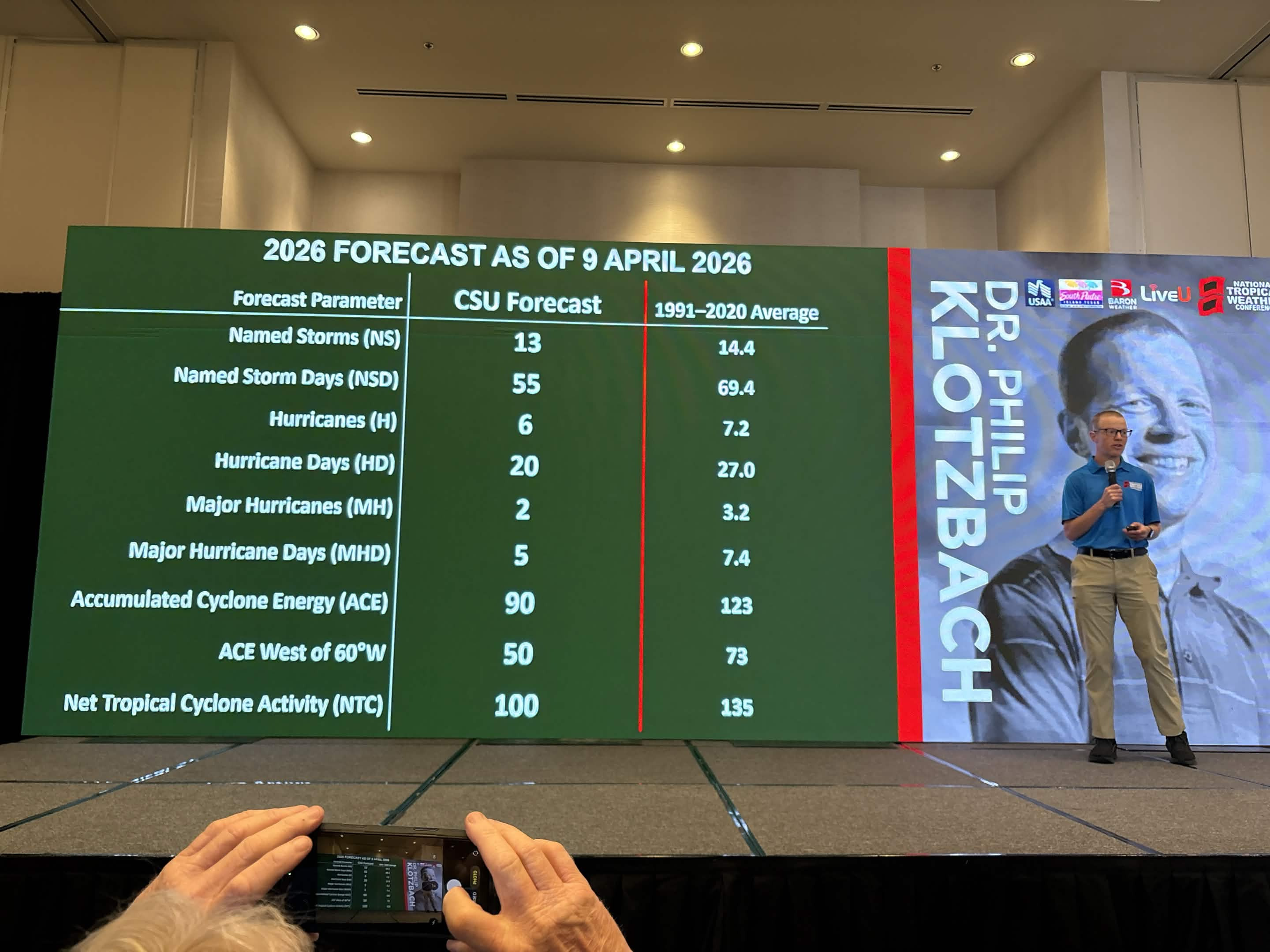
1. Seasonal Numbers at a Glance
CSU is projecting activity levels roughly 75% of a typical season.
- Named Storms: 13 (Average: 14.4)
- Hurricanes: 6 (Average: 7.2)
- Major Hurricanes (Cat 3+): 2 (Average: 3.2)
- Accumulated Cyclone Energy (ACE): 90 (Average: 123)
2. The Florida Outlook: Landfall Probabilities
While the overall storm count is lower, Florida remains the most vulnerable state in the U.S. The 2026 report provides specific probabilities for major hurricane landfalls:
- Florida Peninsula (South and East of Cedar Key): 15% (Long-term average: 21%)
- Gulf Coast and Panhandle (West of Cedar Key to Brownsville, TX): 20% (Long-term average: 27%)
- Proximity Risk: There is a 43% chance of a hurricane passing within 50 miles of Florida and a 21% chance of a major hurricane doing so.
3. Primary Drivers: The "El Niño" Factor
The defining feature of the 2026 season is the transition from a weak La Niña to a moderate-to-strong El Niño during the peak months (August–October).
- Wind Shear: El Niño typically creates high vertical wind shear across the Atlantic's Main Development Region (MDR). This "rips" storms apart before they can organize.
- Atmospheric Stability: Sinking air (subsidence) over the Caribbean and Atlantic is expected to suppress storm formation further.
- Atlantic Temperatures: While the Atlantic remains warm, it is not as anomalously hot as in recent record-breaking years, and the shear from El Niño is expected to be the dominant "hurricane slayer" this season.
4. Historical Analogs
CSU identifies years with similar climate setups to help predict 2026’s behavior. The primary analog years are:
- 2006 and 2009: Very quiet seasons for Florida landfall due to strong El Niño conditions.
- 2015: An extremely quiet year for the U.S. East Coast.
- 2023: A high storm count (20) but mostly storms that stayed out to sea, though Florida’s Big Bend was hit by Hurricane Idalia.
- Quality over Quantity: A below-average forecast does not mean zero risk. Forecasters frequently cite 1992 (Hurricane Andrew) as the ultimate warning: a very quiet, below-average year that produced one of the most devastating Category 5 landfalls in Florida history.
- Western Formation: Because El Niño suppresses storms in the deep tropics, 2026 may see more "homegrown" development in the Gulf of Mexico or Western Caribbean. These storms often have shorter lead times for us here in Florida.
Your preparations should be identical to any other year. See https://www.floridadisaster.org/planprepare/preparing-for-hurricane-season/
One thing to note, this year has a higher chance for early season activity, even if only tropical storms. We'll be watching here at flhurricane.
This year we make it very easy to share images in posts, copy paste them in directly, or upload them for a button. You can then resize/crop them if you want. This is so you can share photos, satellites, model images and simple gif animations this year.
Windows folks can hit "Windows Key+Ctrl+S" to take snippets from your screen and then paste into here in the replies. more to come this year.
Reply here with your own guesses at numbers, which will close around the start of the season.

