
Hurricane Melissa Approaches Jamaica
Posted: 05:13 PM 25 October 2025 | 8 Comments | Add Comment | Newest: 05:15 PM 28-Oct EDT
Melissa is exiting northwestern Jamaica, now no longer a high-end Major hurricane, but a hurricane that is growing in size. Some restrengthening is also forecast, and eastern Cuba and the southeastern and central Bahamas should be rushing their preps to protect life and property to completion.
Ciel
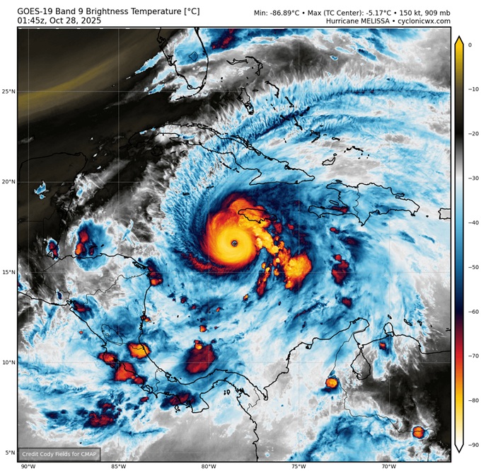
11:00AM EDT 28 October 2025 Update
Melissa has become one of planet earth's top strongest landfalls in all of recorded history, having continued to intensify into landfall.
Now conservatively 185 MPH, pressure down to 892mb.
NHC Update Text:
Quote:
...EXTREMELY DANGEROUS CATEGORY 5 MELISSA ABOUT TO MAKE LANDFALL IN JAMAICA...
...CATASTROPHIC WINDS, FLASH FLOODING, AND STORM SURGE OCCURRING ON THE ISLAND...
SUMMARY OF 1100 AM EDT...1500 UTC...INFORMATION
-----------------------------------------------
LOCATION...17.9N 77.9W
ABOUT 40 MI...60 KM SE OF NEGRIL JAMAICA
ABOUT 235 MI...380 KM SW OF GUANTANAMO CUBA
MAXIMUM SUSTAINED WINDS...185 MPH...295 KM/H
PRESENT MOVEMENT...NNE OR 25 DEGREES AT 9 MPH...15 KM/H
MINIMUM CENTRAL PRESSURE...892 MB...26.34 INCHES
WATCHES AND WARNINGS
--------------------
CHANGES WITH THIS ADVISORY:
The Government of Cuba has issued a Hurricane Warning for the province of Las Tunas and a Tropical Storm Warning for the province of Camaguey.
The Meteorological Service of the Bahamas has discontinued the Hurricane Watch for the Turks and Caicos islands.
SUMMARY OF WATCHES AND WARNINGS IN EFFECT:
A Hurricane Warning is in effect for...
* Jamaica
* Cuban provinces of Granma, Santiago de Cuba, Guantanamo, Holguin, and Las Tunas
* Southeastern and Central Bahamas
A Tropical Storm Warning is in effect for...
* Haiti
Ciel
11:00PM EDT 27 October 2025 Update
NHC Key Messages:
Quote:
1. Jamaica: Remain in your safe shelter. Catastrophic flash flooding and numerous landslides are expected through Tuesday. The eyewall’s destructive winds may cause total structural failure, particularly in higher elevations, leading to widespread infrastructural damage, prolonged power and communication outages, and isolated communities. Along the southern coast, life-threatening storm surge and damaging waves are anticipated through Tuesday. Failure to take immediate action may result in serious injury or significant loss of life.
2. Haiti and the Dominican Republic: Catastrophic flash flooding and landslides are expected across southwestern Haiti and southern portions of the Dominican Republic through midweek. In Haiti, extensive infrastructural damage and isolation of communities is likely. Tropical storm conditions are expected late Tuesday and Wednesday.
3. Eastern Cuba: Heavy rainfall with life-threatening flash flooding and landslides is expected to begin shortly. Life-threatening storm surge and damaging winds are expected late Tuesday and Tuesday night. Preparations should be rushed to completion.
4. Southeast and Central Bahamas and the Turks and Caicos: Hurricane conditions, life-threatening storm surge, and heavy rainfall are expected across portions of the southeast and central Bahamas on Wednesday. Residents should follow advice given by local officials and be sure to have preparations complete by Tuesday night. Tropical storm conditions, heavy rains, and a significant storm surge is expected in the Turks and Caicos Islands on Wednesday.
Ciel
10:00PM EDT 27 October 2025 Update
Melissa has resumed tracking north-northeast, but unlike a few days ago, this motion this time could also favor additional strengthening, however unbelievably so.
Melissa is now over some of the warmest, and deeply warmest, waters of the entire world, having tracked west of a (relatively) 'cooler' (less warm) eddy that is now to the cyclone's east. At the same time, the approaching trof that will ultimately sweep her up, is creating a very favorable outflow (exhaust) channel. It is not inconceivable that Melissa generally maintains or even intensifies further into landfall, save hard-to-foresee dynamics such as Eyewall Replacement Cycles. At a minimum, the hurricane appears to be strengthening further tonight.
Ciel
8:45PM EDT 27 October 2025 Update
Melissa continues tracking a touch west/west-southwest of forecast. Essentially, the more Melissa tracks w/sw/s, the more favorable environment for intensification the cyclone encounters. The stronger the cyclone gets, the more it feels the west-southwestward shove of the high pressure that is draped across to its north/northeast. Rinse. Repeat. While this is unlikely to continue forever, as a scouring trof is pushing off the CONUS that will most likely sweep Melissa up to the north-northeast, the hurricane is getting more time in even more favorable conditions, with a greater portion of Jamaica only now more likely to be in the typically worst Right Front Quadrant. Not ideal.
All this was discussed in our Melissa Forecast Lounge a few times. The Lounge is where we continue to do some deeper dives into modeling and more with Melissa.
Ciel
2:00PM EDT 27 October 2025 Update
Melissa is setting records. In fact, it appears that Melissa may now have the driest eye ever recorded on planet earth.
The 2PM NHC update pegs Melissa's maximum sustained winds at 175 MPH at the surface, but recon and satellite yet again support higher.
Recon recently measured winds at 1,000' above sea level of 240 MPH in the Right-Front-Quadrant (RFQ). Based on the current forecast track, locations on the mountainous island of Jamaica in the hurricane-force radii and within the RFQ may very well experience these winds, and several of these spots are well-populated.
Taking Mandeville as an example. According to Wikipedia, "Mandeville is the capital and largest town in the parish of Manchester in the county of Middlesex, Jamaica. In 2005, the town had an estimated population of 50,000, and including the immediate suburbs within a radius of 16 km the total population was about 72,000." Mandeville's elevation is roughly 2,000' above sea level.
11:00AM EDT 27 October 2025 Update
NHC goes with 165MPH as of the 11AM update today. This could be conservative. Recon data supports higher, and much higher at elevated locations a few hundred feet up, which are certain to impact portions of the island they cross with gusts well over 200 MPH.
On its current forecast track, Jamaican locations within about a 20 mile radius of the eye are likely to be laid in waste, unrecognizable and unlivable for weeks, possibly months, and in some places, potentially years. Flash flooding and land/mudslides will also do a number on areas even outside of the hurricane-force wind radii. Sheltering outside of locations known to be prone to flash flooding and landslides is recommended.
Ciel
5:30AM EDT 27 October 2025 Update
2025 just hit a massive milestone with Melissa becoming the third Category 5 of the year, putting 2025 only behind 2005 for numbers of Category Fives in any one season.
Recon has found pressures down to 917mb, still falling. Recon has also found winds arguably supportive of higher than the 5AM Advisory of 160MPH, still increasing. In fact, a dropsonde found the mean wind in the lowest 150 meters to be 180 MPH. Even a little higher speed than that was recorded at the proxy surface. Thus, the 5AM Adv #24 could be conservative.
It cannot be overstated how potentially dangerous Melissa is. Efforts to protect life and property should be rushed to completion in warned zones.
NHC
Quote:
...DESTRUCTIVE WINDS AND STORM SURGE AND CATASTROPHIC FLOODING WILL WORSEN ON JAMAICA THROUGH THE DAY AND INTO TONIGHT...
WATCHES AND WARNINGS
--------------------
CHANGES WITH THIS ADVISORY:
The government of the Bahamas has issued a Hurricane Watch for the central and southeastern Bahamas and the Turks and Caicos Islands.
SUMMARY OF WATCHES AND WARNINGS IN EFFECT:
A Hurricane Warning is in effect for...
* Jamaica
* Cuban provinces of Granma, Santiago de Cuba, Guantanamo, and Holguin.
A Hurricane Watch is in effect for...
* Southeastern and central Bahamas
* Turks and Caicos Islands
A Tropical Storm Warning is in effect for...
* Haiti
* Cuban province of Las Tunas
Ciel
12:30PM EDT 26 October 2025 Update
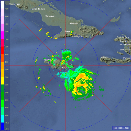
Melissa ended her southwesterly motion this morning and is now tracking generally west to west-northwest, possibly running headstrong into a little more shear, while also having ended her overnight DMAX cycle. These external and internal forces could be resulting in what is shown on radar out of Kingston, Jamaica, to be an open eyewall and some hints of the possible beginnings of an Eyewall Replacement Cycle (ER). Whatever the reasons, for the time being, Melissa has stopped intensifying, but remains an extremely powerful and dangerous Category Four MAJOR.
Melissa is not a hurricane to second guess in a year that, while so far very lucky for most in terms of landfalls, has still more or less kept up with the theme of the Atlantic basin since 1995. In fact, together with 2025's previous Majors (Gabrielle, Humberto and Erin), 2025 now ties with only 2005, 2008 and 2020 for the most 50+ knot RI events in a season (4): Gabrielle, Humberto, Erin and now Melissa. h/t Kieran Bhatia
SUMMARY OF WATCHES AND WARNINGS IN EFFECT AS OF THIS UPDATE:
A Hurricane Warning is in effect for
* Jamaica
A Hurricane Watch is in effect for
* Southwestern peninsula of Haiti from the border with the Dominican Republic to Port-Au-Prince
* Cuban provinces of Granma, Santiago de Cuba, Guantanamo, and Holguin.
A Tropical Storm Warning in effect for...
* Southwestern peninsula of Haiti from the border with the Dominican Republic to Port-Au-Prince
Ciel
Original Update
Melissa is now a hurricane and has a rare forecast calling for a Category 5 major hurricane before landfall, impacts will start to pick up tomorrow and increase in intensity rapidly Monday and landfall possibly early Tuesday morning in the pre-dawn areas somewhere in Jamaica.
If the forecast is correct, it will be the strongest hurricane to impact Jamaica since records began. ;
Active Jamaica Radar Loop:
Melissa Event Related Links
Tropical Tidbits Page on system
Flhurricane Satellite Floater Animation of Melissa
GOES Floater
Tomer Berg Info page for Melissa
CyclonicWx Page for Melissa
Clark Evans Track Model Plot of Melissa
(Animated!) Model Plots in Google Earth - In Google Maps
Clark Evans Intensity Model Plot of Melissa (Animated!)
Clark Evans Track Plot of Melissa
Clark Evans Top 10 Analog Storms for Melissa
http://www.ral.ucar.edu/guidance/realtime/current/ More model runs on from RAL/Jonathan Vigh's page
NRL Info on Melissa -- RAMMB Info
COD Atlantic Satellite View
StormCarib Reports from the Caribbean Islands
Caribbean Weather Observations
Full Caribbean Radar Composite
Caribbean Broadcast Corporation (TV/Radio from Antilles)
Jamaica Storm Info/Media
Jamaican Meteorological Service
Jamaica Office of Disaster Preparedness & Emergency Management
Bermuda Newspapers/Media/Info:
Jamaica Live Cameras
Timelapses and more from Jamiaca
Jamaica Power Outage map

