cieldumort
Moderator

Reged:
Posts: 2322
Loc: Austin, Tx
|
|
10:30AM CDT Update 23 June
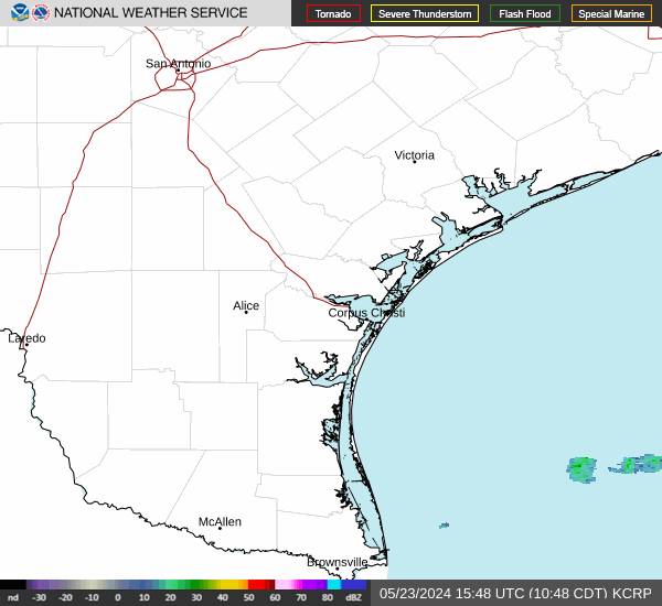
Invest 93L began coming together overnight and now has a much more compact and better defined circulation with deep convection. Quite small over all. Recon is in there and it seems like a coin toss as to whether or not determines it to be a TD just heading into coming ashore.
Impacts for Mexico will largely be the extra heavy rains falling on areas that neither need or want it after Alberto.
12:30PM EDT Update 22 June
Recon's first flight into the broad low pressure area in the western Gulf of Mexico has just departed Keesler AFB. While conditions for development do not look as favorable as they did for pre-Alberto before it, and the system - Invest 93L - is not nearly as large, heavy rains will be falling over places that are still cleaning up after significant flooding from Tropical Storm Alberto. New and additional flooding over extreme south Texas and Mexico is possible to likely regardless of development.
Elsewhere, the well-defined tropical low pressure in the SW Atlantic, Invest 92L, has moved just inland along the coast of SE Georgia, bringing with it rounds of showers and a few thunderstorms that are mostly still over the open waters south to east of the center, owing to persistent shear and nearby dry air.
6:30AM EDT Update 21 June
Recon is en route to investigate 92L. Based on currently available ship and buoy reports, the system possibly does have a well enough defined low level circulation and could already be nearing or at tropical storm force in a small radius, but enough uncertainty remains for to be cautious. However, any increase in their confidence would likely trigger Advisories for northeast FL to the SE US Coast. Recon will determine whether or not it is already a tropical cyclone.
92L is a small system, and as such, its intensity can go up or down quicker than a lumbering and large system such as Alberto, and is moving into an area somewhat more favorable for continued organization. Those in its track may want to consider treating it as if it were a small tropical cyclone, regardless of what recon does or does not find here in a few hours.
-Ciel
10:40AM EDT Update 19 June
Alberto has made landfall in Mexico this morning, causing flooding rainfall there and in parts of texas, as well as coastal flooding.
92L now has a 40% chance to develop, and is a very small area not well picked up by models, but in a area of low shear, recon is scheduled to head out there this afternoon. If it were to make landfall, the next name is Beryl, and it would be in north Florida (north of Daytona). Since it's a very small system, only the area near landfall will likely see much. Rip currents along the beach will be issues there.
4:30PM CDT Update 19 June
Tropical Storm Alberto continues in the Gulf, bringing rain and some coastal surge flooding to the Texas coast.
Invest 92L is now being tracked with the area east of the Bahamas, at the 2PM outlook development chances were at 20%, but likely to rise at 8PM.
9AM CDT Update 19 June
It appears that Tropical Storm Alberto has formed from Potential Tropical Cyclone One ("Storm 1L"). The gradual organization continued overnight and with pressures continuing to drop deep convection has now wrapped around and over the center.
As Advisories are already up, the only real thing that will be changing in the short-term is that they will be issuing advisories with the name. Impacts will largely be the same. While perhaps a bit more focused over Mexico and extreme south Texas, 01L remains a very large system over all, and heavy rains will cover this large area.
10AM CDT Update 18 June
Recon is presently flying its second mission into Potential Tropical Cyclone One this morning and the information they collect will help sort out a few things.
For one, the system has not yet become a tropical cyclone, and may in fact be organizing a bit out of step with earlier pre-development stage forecasts. Based on morning visible satellite loops, 01L could be a touch north and east of where it has been forecast to be. This is not surprising given that 01L is still a sprawling gyre system with multiple embedded transient lobes and what is generally a broad overall "center."
Given that the storm is likely to continue to have a very large area of weather, regardless of precise track and technical classification, those in the western Gulf of Mexico should continue to monitor and prepare for a very wet and regionally blustery strong tropical low pressure. As we have just seen with Invest 90L over Florida, it does not take a bona fide tropical cyclone to bring similar and at times destructive, life-threatening weather.
Elsewhere, the Area of Interest east of the Bahamas is struggling to develop, in part due to a blast of shear being enhanced by the outflow around the very large 01L and plenty of dry air overhead and to its west. This feature has a low chance for development, probably "highest" the closer it gets to the southeast US, and so remains worthy of monitoring. Also, just behind 01L another gyre low is expected to form and take a similar track to that of 01L ahead of it. Between this week and next, some locations in Central America, Mexico and Texas may see tremendous rain totals.
CURRENT SUMMARY OF WATCHES AND WARNINGS IN EFFECT AS OF 10AM CDT:
A Tropical Storm Warning is in effect for the Texas coast from Port O'Connor southward to the mouth of the Rio Grande, the northeastern coast of Mexico south of the mouth of the Rio Grande to Puerto de Altamira.
Original Update
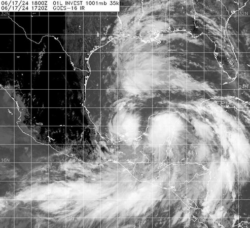
Watches and Warnings are now going up for the Invest in the Bay of Campeche that is already producing sustained winds into tropical storm force and likely to become a bona fide Tropical Cyclone prior to landfall. The first name on the list this year is Alberto.
Quote:
Potential Tropical Cyclone One Advisory Number 1
NWS National Hurricane Center Miami FL AL012024
400 PM CDT Mon Jun 17 2024
...LOW PRESSURE AREA OVER THE BAY OF CAMPECHE EXPECTED TO BRING
HEAVY RAINFALL THREAT TO PARTS OF THE WESTERN GULF COAST...
...TROPICAL STORM WATCH ISSUED FOR PARTS OF THE COAST OF TEXAS AND
NORTHEASTERN MEXICO...
SUMMARY OF 400 PM CDT...2100 UTC...INFORMATION
----------------------------------------------
LOCATION...20.3N 93.2W
ABOUT 380 MI...615 KM SE OF LA PESCA MEXICO
ABOUT 470 MI...755 KM SE OF BROWNSVILLE TEXAS
MAXIMUM SUSTAINED WINDS...40 MPH...65 KM/H
PRESENT MOVEMENT...NNW OR 345 DEGREES AT 7 MPH...11 KM/H
MINIMUM CENTRAL PRESSURE...1001 MB...29.56 INCHES
WATCHES AND WARNINGS
--------------------
CHANGES WITH THIS ADVISORY:
A Tropical Storm Watch has been issued for the Texas coast from Port O'Connor southward to the mouth of the Rio Grande.
The government of Mexico has issued a Tropical Storm Watch for the northeastern coast of Mexico south of the mouth of the Rio Grande to Boca de Catan.
Forecast Lounge is up on Storm 01L Lounge
Elsewhere, we have keen eyes on the presently non-tropical area of low pressure to the east of the Bahamas and also have a Forecast Lounge up for it as well: Area East of Bahamas Forecast Lounge
|
MikeC
Admin
Reged:
Posts: 4561
Loc: Orlando, FL
|
|
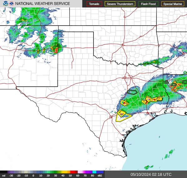
Recon is again this morning checking it out, I'm not fully convinced they will pull the trigger for advisories, but it'll be close either way, if they do it'll be for a tropical depression. So we may know by 11 am if they do so or not based on the recon there (outside of the pressure, which is high). The convection is offshore, two records (Radar and a palm coast webcam) are on the image recordings section of this site for this system.
Convection is better on the south side than I expected this morning, however.
A bunch of other landfall area webcams
|
cieldumort
Moderator
Reged:
Posts: 2322
Loc: Austin, Tx
|
|
Product: Air Force Vortex Message (URNT12 KNHC)
Transmitted: 21st day of the month at 14:02Z
Agency: United States Air Force
Aircraft: Lockheed WC-130J Hercules with reg. number AF97-5303
Mission Purpose: Investigate second suspect area (flight in the North Atlantic basin)
Mission Number: 2
Observation Number: 11
A. Time of Center Fix: 21st day of the month at 13:37:20Z
B. Center Fix Coordinates: 30.37N 79.52W
B. Center Fix Location: 122 statute miles (196 km) to the NE (49°) from Daytona Beach, FL, USA.
C. Minimum Height at Standard Level: Not Available
D. Minimum Sea Level Pressure: 1014mb (29.95 inHg) - Extrapolated
E. Dropsonde Surface Wind at Center (Undecoded): NA
F. Eye Character: Not Available
G. Eye Shape: Not Available
H. Estimated (by SFMR or visually) Maximum Surface Wind Inbound: 29kts (33.4mph)
I. Location & Time of the Estimated Maximum Surface Wind Inbound: 23 nautical miles (26 statute miles) to the W (274°) of center fix at 13:29:30Z
J. Maximum Flight Level Wind Inbound: From 24° at 33kts (From the NNE at 38.0mph)
K. Location & Time of the Maximum Flight Level Wind Inbound: 51 nautical miles (59 statute miles) to the WNW (290°) of center fix at 13:20:00Z
L. Estimated (by SFMR or visually) Maximum Surface Wind Outbound: 37kts (42.6mph)
M. Location & Time of the Estimated Maximum Surface Wind Outbound: 5 nautical miles to the E (95°) of center fix at 13:40:30Z
N. Maximum Flight Level Wind Outbound: From 163° at 33kts (From the SSE at 38.0mph)
O. Location & Time of the Maximum Flight Level Wind Outbound: 3 nautical miles to the ENE (69°) of center fix at 13:39:30Z
P. Maximum Flight Level Temp & Pressure Altitude Outside Eye: 22°C (72°F) at a pressure alt. of 416m (1,365ft)
Q. Maximum Flight Level Temp & Pressure Altitude Inside Eye: 23°C (73°F) at a pressure alt. of 423m (1,388ft)
R. Dewpoint Temp (collected at same location as temp inside eye): 23°C (73°F)
R. Sea Surface Temp (collected at same location as temp inside eye): Not Available
S. Fix Determined By: Penetration, Wind, Pressure and Temperature
S. Fix Level: 1,500 feet
T. Navigational Fix Accuracy: 0.02 nautical miles
T. Meteorological Accuracy: 1 nautical mile
Remarks Section:
Maximum Flight Level Wind: 33kts (~ 38.0mph) which was observed 51 nautical miles (59 statute miles) to the WNW (290°) from the flight level center at 13:20:00Z
Sea Level Pressure Extrapolation From: Below 1500 feet
|
MikeC
Admin
Reged:
Posts: 4561
Loc: Orlando, FL
|
|
Recon just found a 53 knot smfr wind reading, I'd expect some sort of upgrade after that if it weren't for the fact that the LLC may be splitting off to the NW now.
|
MikeC
Admin
Reged:
Posts: 4561
Loc: Orlando, FL
|
|
92L Remains at 60% chance for development as of the 2PM . the LLC running off and the latest convection dissipating makes me think it may not develop before landfall. Also worth noting the recon pressure is pretty high as well which is another reason not to issue advisories.
|
|


 Threaded


