cieldumort
Moderator

Reged:
Posts: 2305
Loc: Austin, Tx
|
|
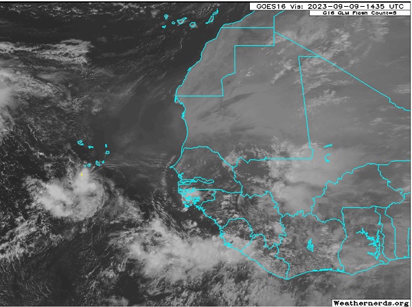
A convectively active low centered south of the Cabo Verde islands, a low that is at best barely identified by models - models that have a challenging time picking up even better developed and even larger systems this far out - continues tracking generally west and staying weak.
There has been some on and off model support for this feature to develop either on its own or once its remnant is effectively absorbed by the larger approaching wave about to exit from Africa behind it.
Collectively, this low, or the merger, does have lukewarm model support for development, with several runs suggesting an ability to sneak in under ridges and getting a little further west. This might be more possible should the feature stay weak for longer, for as a general rule of thumb, Cape Verde hurricanes during an El Niño season should in theory, and so far this year in practice, run into a lot of S and now also approaching continental trofs that could send them recurving, or even sheared to bits.
This feature is not yet Invest tagged, and hasn't even been included in any products, but soon may be, and the title would be updated accordingly.
Like Lee ahead of it, we would have a very long time to keep an eye on this should it pop.
The lead low located south of the Cabo Verdes in the first post image was Invest tagged 09/10/23 afternoon, 97L.
The trailing wave was Invest tagged 98L as of 09/11/23 2023, centered midday Monday near 11.5N 21.1W.
NHC and the models have not yet resolved which wave becomes dominant, or perhaps even stay separated. It is complicated and until one becomes a T.C. this lounge will consider them as one larger area of lower pressure with embedded meager or small circulations. 09/11/23/7PM EDT - Ciel
TD 15 9/15/23 - Ciel
Edited by cieldumort (Fri Sep 15 2023 06:08 PM)
|
cieldumort
Moderator
Reged:
Posts: 2305
Loc: Austin, Tx
|
|
GFS Today's 12Z run of the has the lead low presently centered south of the Cabos tracking sharply northwest behind Margo, and instead fully locks on do the wave about to roll off west Africa as the sole and primary. It develops this second wave into another long-track CV, recurving well east of Florida and end of run is about 400 miles east of Delaware.
Seems like a good time to mention that beyond 120 hours with a system that hasn't even yet been flagged with an Invest tag is almost quackery, but adding the additional end-of-run info for a complete picture.
ICON keeps the lead low very weak and slows it down while shearing it out, allowing the eastern wave to absorb it and developing.
GEM also appears to keep the lead low very weak and has it overtaken by the larger wave east of it, developing by next Saturday before reaching 50W.
ECMWF It is less clear whether the EURO has the lead low overtaken or not, but in any event it seems to use it as the nucleus for a future Nigel which heads W-WNW over the next 7 days without much appreciable organization beyond perhaps a large T.D. (which does argue for the lead low being overtaken by the larger wave to its east), and then Tropical Storm (Nigel?) by Saturday the 16th while west of 45W and south of 25N.
It is worth adding that the 0z EURO ensemble implied probability for the lead low "nucleus" to develop into a tropical cyclone within the next 72 hours is about 65%.
Edit: 12Z EURO ensemble implied probability of genesis within 72 hours is now up to 75% on the lead low/nucleus.
Edited by cieldumort (Sat Sep 09 2023 08:11 PM)
|
cieldumort
Moderator
Reged:
Posts: 2305
Loc: Austin, Tx
|
|
From Quote:
Tropical Weather Outlook
NWS National Hurricane Center Miami FL
800 PM EDT Mon Sep 11 2023
For the North Atlantic...
1. Eastern Tropical Atlantic (AL97):
A weak area of low pressure located several hundred miles west-southwest of the Cabo Verde Islands continues to produce disorganized shower and thunderstorm activity primarily to the west of its center. Development of this system is unlikely before it merges with a another area of low pressure (AL98) to its east during the next couple of days.
* Formation chance through 48 hours...low...10 percent.
* Formation chance through 7 days...low...10 percent.
2. Eastern and Central Tropical Atlantic (AL98):
A broad area of low pressure has formed along a tropical wave located over the eastern tropical Atlantic south of the Cabo Verde Islands. This system is currently producing disorganized showers and thunderstorms but environmental conditions appear conducive for gradual development of this system, especially after is merges with an area of low pressure to its west (AL97). A tropical depression is likely to form from the combined system by this weekend as it moves westward to west-northwestward at 15 to 20 mph over the central
tropical Atlantic.
* Formation chance through 48 hours...low...10 percent.
* Formation chance through 7 days...high...70 percent.
Forecaster Papin
|
IsoFlame
Weather Analyst

Reged:
Posts: 295
Loc: One block off the Atlantic Oce...
|
|
In the wake of Lee's weekend jaunt through the Canadian Maritime, I'm wondering if high pressure will eventually build next week, then strengthen as a re-enforcing high builds southward the following weekend, eventually setting up a 1030 mb (or stronger) ridge over and offshore from New England, possibly extending down the eastern seaboard the following week (as indicated by some modeling). If the high centers off the mid-Atlantic coast later in the month, it should effectively block any approaching TC and cut off the western Atlantic's "freeway" of Major re-curving hurricanes. Hopefully, none of the distant areas of concern progressing across the central Atlantic will gain longitude (before latitude) and possibly be blocked from re-curving well out to sea.
It's getting to be the time of year for strong/cool high pressure to eventually build southward down the eastern seaboard, along with the possibility of a stalled frontal boundary to lay up over the northern Gulf and extend across north Fla. It would not be of great surprise to me if "home-grown" tropical cyclogenesis occurs toward the end of Sept over the very warm waters of the GOMEX, SW Atlantic and western Caribbean.
--------------------
CoCoRaHS Weather Observer (FL-VL-42) & Surf Forecaster: https://www.surf-station.com/north-florida-surf-forecast-3/
|
cieldumort
Moderator
Reged:
Posts: 2305
Loc: Austin, Tx
|
|
The first-out-of-the-gate wave, 97L, has indeed become the nucleus for tropical cyclone generation, with flipping the odds (97L was just at 10% and 98L was at 70%), to 97L now being the system to track and at 80%, with 98L completely dropped.
This is an interesting development and could have some impacts on future track, which most models increasingly suggest is recurving out to sea. Nonetheless, 97L is at a lower latitude and has not yet developed, leaving open possibilities. There are some runs that do want to pull it back towards the northeastern and/or eastern Canada roughly ten days out, as these runs forecast high pressure building back in over the western Atlantic on top of it.
The title is being changed back to 97L now. at 50% of TCG within two days and 80% within seven. Quote:
ropical Weather Outlook
NWS National Hurricane Center Miami FL
800 AM EDT Wed Sep 13 2023
1. Eastern and Central Tropical Atlantic (AL97):
A broad area of low pressure over the eastern tropical Atlantic continues to produce some disorganized showers and thunderstorms. Gradual development of this system is expected over the next few days while the system moves west-northwestward to northwestward at 10 to 15 mph, and a tropical depression is likely to form by this weekend over the central tropical Atlantic.
* Formation chance through 48 hours...medium...50 percent.
* Formation chance through 7 days...high...80 percent.
|
|


 Threaded


