cieldumort
Moderator

Reged:
Posts: 2484
Loc: Austin, Tx
|
|
Models and ensemble members are increasingly warming up to the idea that a broad area of low pressure will form in the western Caribbean or across Central America (in the form of a gyre) next week, and out of this region a tropical cyclone could develop around the end of the month or early November. Generally, operational and ensemble member runs suggest about a 40% chance of TC genesis in this region, which would immediately be landlocked, and as such, we are starting a Lounge on this modeled feature.
More details to come
|
cieldumort
Moderator

Reged:
Posts: 2484
Loc: Austin, Tx
|
|
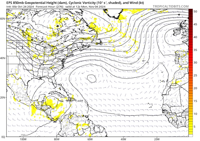
In the EPS model run shown below (image courtesy Tropical Tidbits), an approaching large scale trof crossing the around the time the forecast calls for an area of low pressure (possibly a TC) to exist in the Caribbean would favor pulling up whatever is there to the north or northeast.

Above: EPS* 850mb level forecast initialized 10-24-0z and valid for 11-04-12z
*ECMWF model's Ensemble Prediction System (Singular vectors and an ensemble of data assimilations).
|
IsoFlame
Weather Analyst

Reged:
Posts: 364
Loc: One block off the Atlantic Oce...
|
|
Anything (tropical or hybrid) coming up from the south, then riding along or not far offshore from Florida's east coast will put an exclamation mark on the severe beach erosion we experienced this month in Daytona Beach Shores from being on the north side of Milton's exiting eye followed by a week of nor'easter conditions during King tides.
Today we have a break in the strong onshore flow, and it's forecast to last into the weekend. But the marine forecast ramps wind up again from the NE 15-20 kts on Monday following a dry frontal passage. Models suggest the strong onshore flow could increase through the week. A TC or hybrid system spinning up in early November will enhance the gradient:
--------------------
CoCoRaHS Weather Observer (FL-VL-42) & Surf Forecaster: https://www.surf-station.com/north-florida-surf-forecast-3/
|
IsoFlame
Weather Analyst

Reged:
Posts: 364
Loc: One block off the Atlantic Oce...
|
|
Based on having consistency over multiple runs for several days, I believe that Florida's central east coast a hundred miles or so north and south of the Cape will be in for a week-long period of strong (possibly gale force) onshore wind starting around Halloween and lasting until Election Day. Given the slow movement of the low (potential TC) coming up from the south into the central or northern Bahamas, SST's and increasing shear will probably limit strengthening to a hurricane, though a strong tropical/hybrid storm not too far off the east coast of Florida is quite possible.
This set-up of a late season low coming up from the south, being pinned down by strong high pressure to the north reminds is reminiscent of the Thanksgiving Day coastal wind/erosion event in 1984 that ravaged the central Florida east coast for 4 days.
--------------------
CoCoRaHS Weather Observer (FL-VL-42) & Surf Forecaster: https://www.surf-station.com/north-florida-surf-forecast-3/
|
IsoFlame
Weather Analyst

Reged:
Posts: 364
Loc: One block off the Atlantic Oce...
|
|
Slower evolution of any Caribbean system(s) given last days-worth of modeling. Some runs suggest formation of a pair of lows- one scooting off to the NE and the other pinned down in the Caribbean Sea by a blocking high to the north, so system remains south of the islands strengthening over what Brian Norcross says is currently "the warmest (upper 80's)/deepest water on the planet".
My gut feeling remains about the same... a slowly evolving TC remaining nearly stationary in the Caribbean, then drifting north across Haiti or eastern tip of Cuba into the Bahamas as a tropical storm (possibly becoming a hybrid system) the week after Election Day. That's as far out as I care to conjugate at this time.
Bottom line for the Milton-battered, extremely vulnerable beaches of east central Florida north of the Cape... more coastal erosion likely through Halloween well into November.
--------------------
CoCoRaHS Weather Observer (FL-VL-42) & Surf Forecaster: https://www.surf-station.com/north-florida-surf-forecast-3/
Edited by IsoFlame (Tue Oct 29 2024 01:05 PM)
|
Owlguin
Weather Hobbyist
Reged:
Posts: 73
|
|
Seems like the models are growing a little bit of a consensus with a system emerging from the Caribbean into the southern gulf. Pretty early still though.
|


 Threaded


