cieldumort
Moderator

Reged:
Posts: 2604
Loc: Austin, Tx
|
|
|
MikeC
Admin
Reged:
Posts: 4794
Loc: Orlando, FL
|
|
The two current invest aren't likely going to amount to much, 90L is likely to develop, but remain weak, and 99L, although persistent, really doesn't have a great shot to develop now, but could later. Areas off the southeast coast from fronts are probably going to be the next development after it, but the next week or two are likely uncharacteristically going to be light. Mid to late September seems like the most likely time for folks to watch. Monitor closely, but nothing concerning right now.
|
MikeC
Admin
Reged:
Posts: 4794
Loc: Orlando, FL
|
|
Very quiet on the long range front outside Fernand. 99L may wind up something in the east Pacific, but as it stands now, recon didn't find the LLC needed to keep it going on the Atlantic side. Turning to ensembles for peak season is pretty unusual, just a hint of a frontal low developing off the coast of Carolina and moving nne for a short-lived weak system, and maybe a wave exiting Africa on September 1st that has the odds stacked against it for development. There's nothing in a favorible location to speak of for the next two weeks or so, later half of September could have more activity, but for the moment it's thankfully very quiet in the Atlantic, other than Fernand moving safely out to sea.
Barbados and surrounding islands are getting some rain from 99L, but that's likely to move out later today. 99L itself missed its window of opportunity to develop in the Atlantic, conditions are too hostile in the Caribbean.
|
IsoFlame
Weather Analyst

Reged:
Posts: 398
Loc: One block off the Atlantic Oce...
|
|
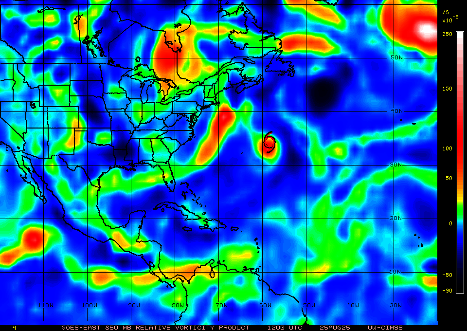
This morning there is a vigorous surge of convection tracking WNW over the western Caribbean Sea south of Cuba that is pushing WNW toward the Yucatan peninsula.
--------------------
CoCoRaHS Weather Observer (FL-VL-42) & Surf Forecaster: https://www.surf-station.com/north-florida-surf-forecast-3/
|
MikeC
Admin
Reged:
Posts: 4794
Loc: Orlando, FL
|
|
Near term, I usually look at the vorticity charts to see if convection aligns with anything for potential with tropical development at the 850 level, if it does, then you have to check closely for low levels. (99L fit the 850 well, but lacked the low level.. you need both for development.) 99L's 850 reflection has tanked since yesterday so it's not doing anything in the Atlantic. Yucatan area has no circulation/vorticity at low or mid levels. The area East of New Jersey is too elongated and also too far north, Fernand is still there
The area near the OK/Texas/New Mexico borders is the one some of the models were hooking into for frontal development in a week off NC, but that's a long shot also. EPAC is going to see most of the activity this week.
|
MikeC
Admin
Reged:
Posts: 4794
Loc: Orlando, FL
|
|
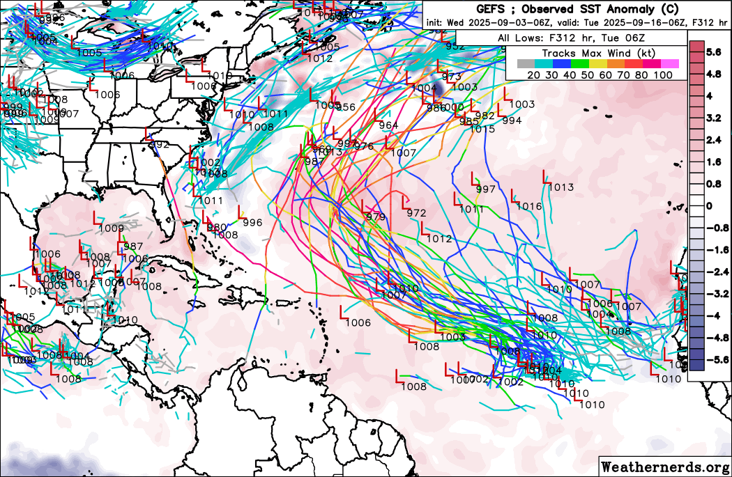
0z Euro shows two MDR waves in the very long run, although the setup for them implies both will likely recurve., if they form (especially the western wave). The icon is very agressive with development right off Africa, but it's alone in that assumption. is not really on board with either.
|
CFHC

Reged:
Posts: 191
Loc: East Central Florida
|
|
12z does develop the wave off Africa, but eventually recurves it (although it does stall and dip south a bit). 12Z Canadian develops it earlier. 12Z Euro is weaker, and stretches it out around 52west longitude. Just not a lot of support at the moment, but something to watch later.
|
CFHC
Reged:
Posts: 191
Loc: East Central Florida
|
|
Gfs and euro and ensembles show more potential for developnent now, but a recurve north of the caribbean islands remains the most likely outcome, bermuda should watch closely. The rest should just monitor.
|
MikeC
Admin
Reged:
Posts: 4794
Loc: Orlando, FL
|
|
This one is up to 60% development, and probably will, if itt gets too far west the will probably annihilate it. :The 12Z icon shows the Caribbean islands need to at least monitor it. But the most likely land impact is still probably Bermuda, maybe even more likely to get closer than Erin around this time. As far as any continental US impacts, extremely unlikely and not really concerned for there, synoptic setup is really not going to allow it to get even as far west as Erin got.
|
MikeC
Admin
Reged:
Posts: 4794
Loc: Orlando, FL
|
|
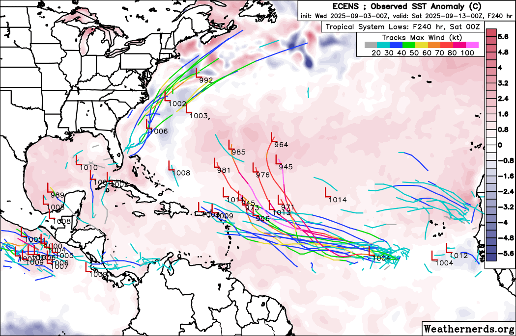
Models haven't changed all that much, still a potential threat to the Leeward islands, and moreso Bermuda. Ensembles have widened today, although most still recurve. Things like the show a bit of a hook after Bermuda, so trends need to be watched, but a US landfall is still extremely unlikely.
Still, the most likely outcome, as of tonight, is that the area in the East Atlantic will recurve near/east of the Leewards and get close to Bermuda. However, a weaker storm in the MDR has a higher chance of getting much closer to the islands (where it could strengthen quickly). So leewards definitely need to monitor.
Euro AI doesn't develop thi sat all, the 18Z euro is much further south than the 12Z, 18Z ensembles are all recurving east of the islands
It may get invest tagged tomorrow, but it's dependent on if a LLC or even coherant convective area can be estimated. (Right now it can't)
|
MikeC
Admin
Reged:
Posts: 4794
Loc: Orlando, FL
|
|
Pretty much status quo on the wave in the east Atlantic today. It's questionable if it'll even get invest tagged again today. Models vary between going over the islands weak, to stronger recrurving, or some in the middle like the Canadian. Most of the euro ensembles are north of the islands, all of the ones are. In the very long range there's a stall near Bermuda on the , which could make it interesting for Bermuda (although this type of movement in the very long range models is suspect. But any direct us landfall seems incredibly unlikely still. For the highest odds, you would have to go with something recurving east of the islands and getting near Bermuda, but it could get close enough to the leeward islands that those folks should watch too. The really is an obstacle for this here that the models are having issues with.
Until the convective area is more sound it's unlikely to get invest tagged (if you can't identify a decent center it doesn't help much) If the near term changes go up, it's more likely to get tagged. The is definitely making the models struggle on run to run consistency. may be more sensitive to that track wise, euro more on the intensity side.
Edited by CFHC (Wed Sep 03 2025 08:22 AM)
|
CFHC
Reged:
Posts: 191
Loc: East Central Florida
|
|
Future posts about this system are in https://flhurricane.com/cyclone/showflat.php?Number=115833&gonew=1#UNREAD
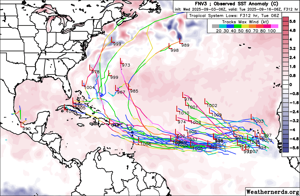
ensemble plots
GFS
Euro
Google
Edited by MikeC (Thu Sep 04 2025 07:32 AM)
|
cieldumort
Moderator
Reged:
Posts: 2604
Loc: Austin, Tx
|
|
I think its fair to say that the folks who really dig in to making long range seasonal forecasts every year are a bit stunned by how 2025 is turning out so far.
We always have our preseason contest here, and I think we all try to do our best in the name of funzies, and so far, mine is looking pretty toast. Predictions made prior to early August are working off of very light info, subject to changes that typically do not materialize until August. And a lot of professional forecasting groups (universities, companies, etc.) that also made forecasts prior to August get the same pass as we do. However, most forecasts made since August have continued with the expectation of an above-average to very active year once all is said and done, and that is becoming more and more difficult to envision verifying.
Just some thoughts as I point out that very few models, aside from our solo bull this season, the , show anything of interest with much consistency over the next couple of weeks(!!) This is incredible.
0z has a sloppy depression or two at best forming out to the end-of-run at 360 hours
0z ICON also has perhaps a sloppy depression or two at best out to the end of its run at 180 hours
0z , copy and paste from above, out to 240 hours
0z AIFS, copy and paste, out to the end of its run at 360 hours
At the moment, it almost looks like the easiest way for the Atlantic basin to see something form that gets any stronger than a TD, would be for a cross-over from the extreme eastern Pacific to find its way into the southwestern Gulf and/or for a CAG to toss one out over on this side of Central America.
Pretty phenomenal state of both the East Pac and Atlantic basins for a cool-neutral year: Active Eastern and Central Pacific, and relatively lifeless Atlantic.
A major shift in some large sub-seasonal players, such as the , might have to turn very favorable for Atlantic-side development, to break this pattern.
|
IsoFlame
Weather Analyst
Reged:
Posts: 398
Loc: One block off the Atlantic Oce...
|
|
Quote:
I think its fair to say that the folks who really dig in to making long range seasonal forecasts every year are a bit stunned by how 2025 is turning out so far.
At the moment, it almost looks like the easiest way for the Atlantic basin to see something form that gets any stronger than a TD, would be for a cross-over from the extreme eastern Pacific to find its way into the southwestern Gulf and/or for a CAG to toss one out over on this side of Central America.
Pretty phenomenal state of both the East Pac and Atlantic basins for a cool-neutral year: Active Eastern and Central Pacific, and relatively lifeless Atlantic.
A major shift in some large sub-seasonal players, such as the , might have to turn very favorable for Atlantic-side development, to break this pattern.
My thoughts for this year, re-enforced by the pattern that has established since Erin, is that the MDR isn't going to produce more than possibly one more named system. I believe there will be a flurry of home-grown activity in the GOMex, SW Atlantic and also possibly the western Caribbean that will bring the2025 season up to the expectations of near normal or slightly above activity. Heck, late August and early September have sent signals of this potential with numerous frontal boundaries penetrating deep into the southeast- some even as far south as the Keys.. Normally we dont see this until late September and early October.
There is plenty of deep, untapped warm water in the favorable late season basin. Unless there is some sort of sun spot ju-ju casting a blanket over the potential for TC in the favored second half of the season areas, it would not surprise me to see a tropical storm and/or a hurricane bracketing Florida a few hundred miles or so on both sides of the peninsula in 2 to 3 weeks.
BTW- I don't think a EPAC crossover is likely given the current "anti-woke" LGBTQ+ political climate.
--------------------
CoCoRaHS Weather Observer (FL-VL-42) & Surf Forecaster: https://www.surf-station.com/north-florida-surf-forecast-3/
|
MikeC
Admin
Reged:
Posts: 4794
Loc: Orlando, FL
|
|
18z is back to active with a CAG system (most likely a phantom spawned by remnants of 91L, and not really enough to take seriously without any other model support and the fact shear around then would be likely very high) and another MDR system that curves and stalls near Bermuda. (Which does have some other ensemble support). So something to keep an eye on. Nothing concerning right now, though.
|
cieldumort
Moderator
Reged:
Posts: 2604
Loc: Austin, Tx
|
|
There are a few features in the basin that look interesting, and during any usual "peak" of a season one could expect something to come of them, but at the moment, conditions for development are running marginal to outright hostile. Nonetheless, a few items of interest as mentioned here and elsewhere include, from closest to land to farthest out:
1. A stalled frontal boundary draped across the Gulf up into the offshore waters of the southeastern US with a few attendant areas of weak low pressure.
2. Whatever is left of the northern extent of former Invest 91L now rounding the Lesser Antilles
3.Wave approaching northeastern South America/southern Lesser Antilles.
4. Wave east of the Cabo Verde Islands near 23W from 17N southward
Big picture-wise, #1 is riddled with shear and it is not obvious how something other than a hybrid could cook up during the next week out of this, unless shear dramatically lessens over crucial portions of the boundary and/or crucial portions of the boundary drift further out south/east out of the range of the high shear zones.
#2 (x 91L) Pretty difficult to see this developing. Maybe fair to give it 2% within 7 days, or one-out-of-fifty odds.
#3 Might be something to keep an eye on if it starts to cook up some persistent deep convection and manages to pull north of South America in time. Perhaps a mention in tomorrow's could be introduced on this feature by depending on how it fairs tonight/overnight.
#4 Has some soft model support. Unfortunately for this wave, the Tropical Atlantic is still loaded with wave kryptonite this season.
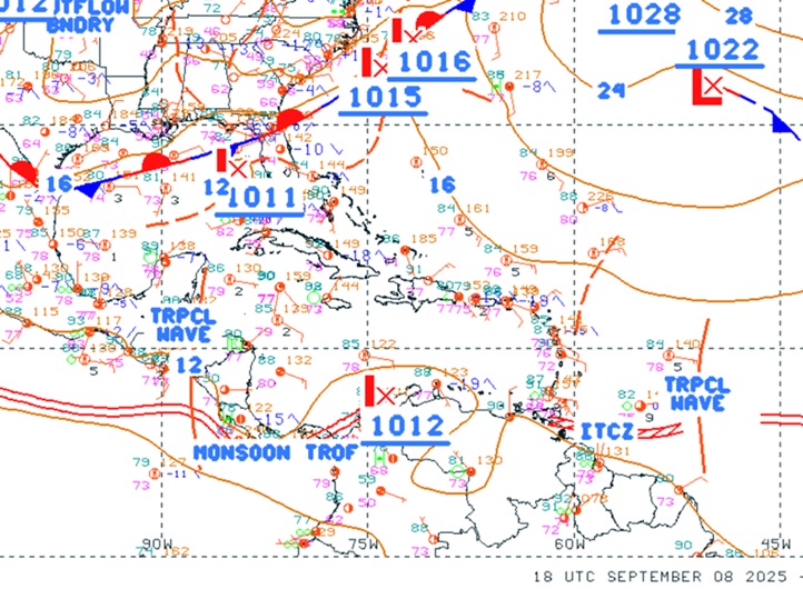
Above: SW Atlantic surface analysis 9-8-25-1800z
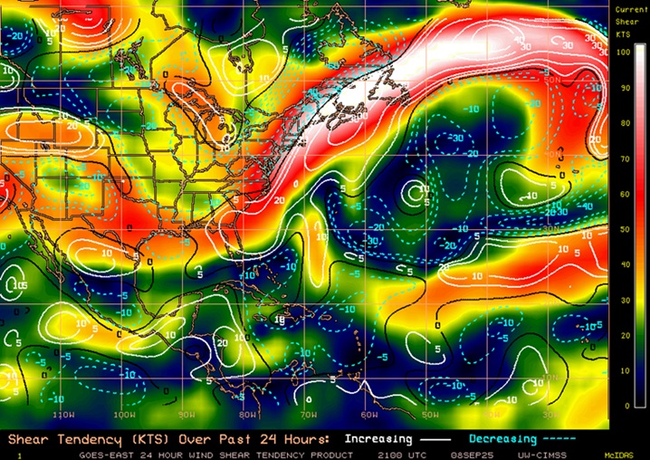
Above: Atlantic basin shear analysis and shear tendency as of 9-8-25-2100z
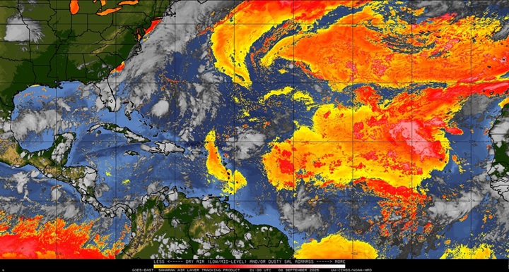
Above: Atlantic basin dry air as of 9-8-25-2100z
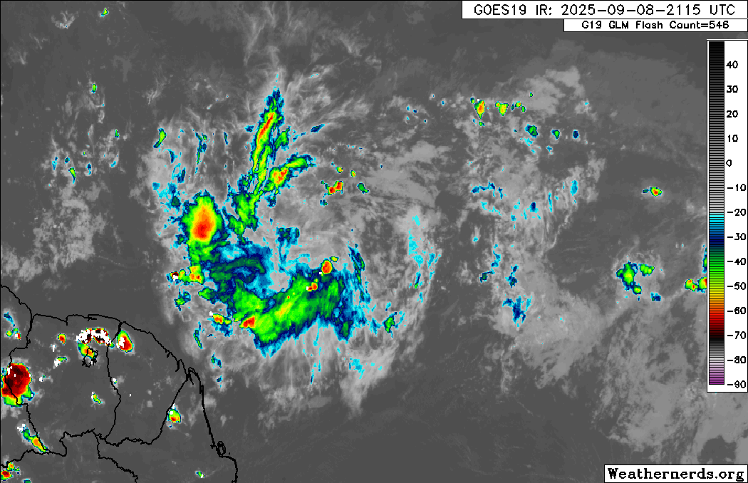
Above: #3 approaching northeastern South America
|
MikeC
Admin
Reged:
Posts: 4794
Loc: Orlando, FL
|
|
The one by south america is very elongated west/east, and has no low level circulation (and the mid levels are weak). I don't see that developing. No 4 has the best shot, but that';s not saying much right now. Pattern is starting to change again, so maybe in a week and a half or two things will be back to being in phase for development.
|
MikeC
Admin
Reged:
Posts: 4794
Loc: Orlando, FL
|
|
The 6z shows nothing this moring. South American area had an ascat pass and showed the issues there, it's got competing vortexes and an elongated mid level. It's not going to develop.
There's never been a september without a named storm (or something that would qualify for a name) going tack to 1851, we're going for an attempt this year.. (Hint: I still don't think that will happen this year either with several weeks left). around 40W has been shunting things for the last few weeks, so when that moves, door is open.
On the animation page I've recorded the 850 vorticity charts, it shows since August 25th the persistant trough from the Gulf to Canada has effectively blocked any "home brew" style systems, while the around 40-50W has killed off any MDR waves, so the current setup is just bad for any type of development. East Pacific is very different from this right now. When the trough off the Southeast goes away, it leaves the door open for more storms, and probably will try to catch up in the lack of activity.
|
MichaelA
Weather Analyst

Reged:
Posts: 954
Loc: Pinellas Park, FL
|
|
This being the climatological peak of the season, the focus for development will begin to shift more toward the Caribbean and the Gulf. If the preseason forecasts are to be verified, a later season peak may be on tap (or not). 
--------------------
Michael
PWS
|


 Threaded


