cieldumort
Moderator

Reged:
Posts: 2738
Loc: Austin, Tx
|
|
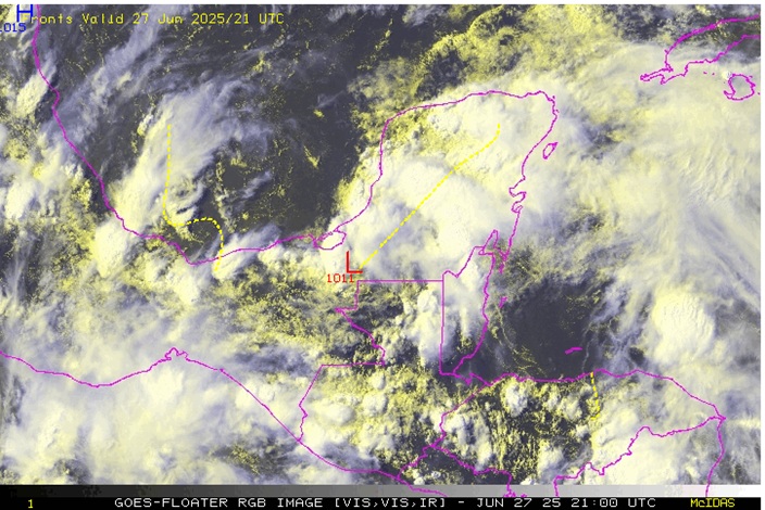
The broad area of low pressure across the Yucan we have been tracking for a few days is close to entering the Bay of Campeche and is starting to show signs of improvement along with some hints that conditions for the development of a quick TD or perhaps a named system could be rising. In fact, EURO ensemble implied development probabilities are nearing 50-50. As such, we are now starting a Lounge on this disturbance, recently Invest-tagged 91L.
This is primarily an eastern Mexico concern for the potential of some inland flooding and perhaps some challenging boating conditions.
Invest 91L has become TD with today's 4PM Advisory and the title has been updated accordingly.
Now Tropical Storm Barry 6/29/25 10AM CDT
Ciel
Edited by cieldumort (Sun Jun 29 2025 11:05 AM)
|
cieldumort
Moderator
Reged:
Posts: 2738
Loc: Austin, Tx
|
|
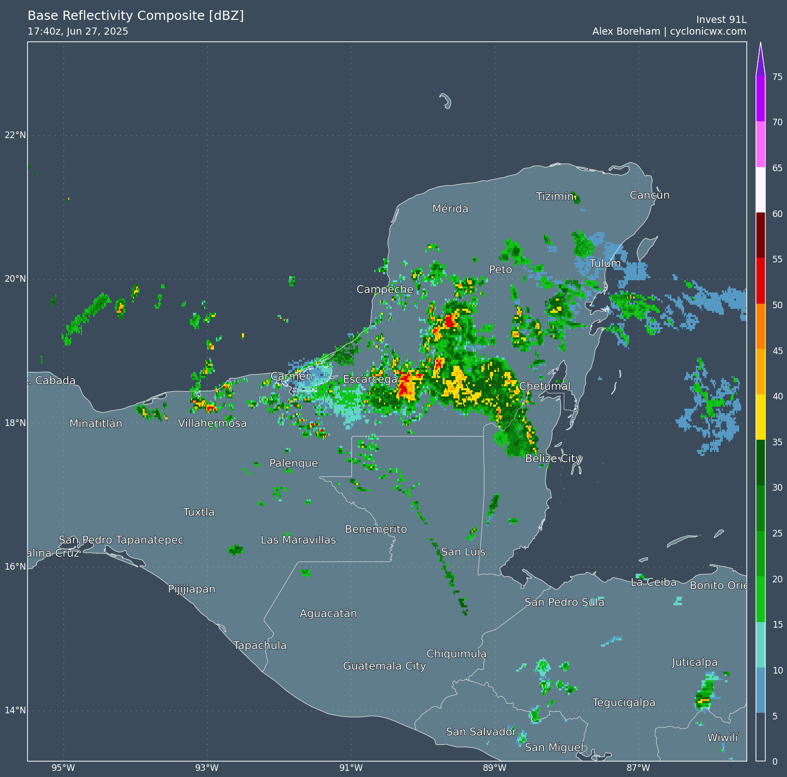
91L continues improving while over the Yucatan and is now starting to enter the BOC as can been seen in the radar image below courtesy CyclonicWx.
Close inspection suggests that as soon as overnight tonight TCG could occur, as water temps are low and at least for now, upper level winds may even become supportive.
|
cieldumort
Moderator
Reged:
Posts: 2738
Loc: Austin, Tx
|
|
|
cieldumort
Moderator
Reged:
Posts: 2738
Loc: Austin, Tx
|
|
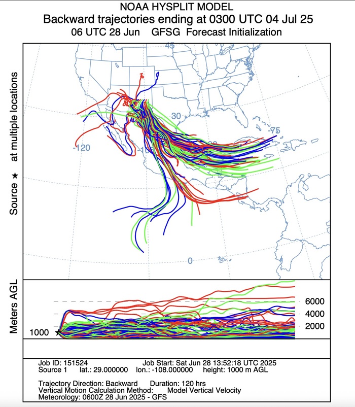
NOAA Hysplit (Hybrid Single-Particle Lagrangian Integrated Trajectory) model, looking backwards 120 hours from 03z July 4, suggests an abundance of moisture from both 91E (possibly our future Barry in the Atlantic) and 95E to its south (likely to become Flossie in the eastern Pacific) will wind up in New Mexico.
|
cieldumort
Moderator
Reged:
Posts: 2738
Loc: Austin, Tx
|
|
A significant portion of former Tropical Storm Barry's moisture, plus additional moisture it helped draw up from the Gulf, combining with its remnant mid/upper level vorticity, conspired with at least one other system to produce a catastrophic flash flood event in central Texas today, July 4.
Unfortunately, this event serves as yet another tragic reminder that often the "weak" ones go on to result in some of the worst impacts due to flooding..
KHOU: Live Coverage: Evacuations underway for Guadalupe River area in Kerrville amid dangerous flooding
|
cieldumort
Moderator
Reged:
Posts: 2738
Loc: Austin, Tx
|
|
Barry's mid-level circulation is still drifting about in central Texas. Precipitable water levels throughout this part of the state also remain incredibly high. Despite several days of ongoing convection and extreme rainfall, the atmosphere is not yet tapped out, given the still very favorable parameters, and flooding remains on the table at least during the early part of the new week.
Documentation of this extreme event is rightfully tracing it back to Barry. Even though the tropical storm was about as marginal as they look on satellite, it did qualify as a tropical cyclone, was a bona fide tropical cyclone, and sadly, history reminds us time and again how often the weak ones and/or the "post-tropical" ones go on to deliver the worst impacts.
As noted in the Wikipedia page about the July 2025 Central Texas Floods :Quote:
"Late on July 3, 2025, the remnant mid-level circulation of Atlantic Tropical Storm Barry became embedded within a broader mid-level trough containing tropical east Pacific remnant moisture. This system developed into thunderstorms which stalled over Central Texas causing heavy rains that caused deadly flooding in that region on July 4–6, especially along the Guadalupe River."
Certainly much can and will be learned about how to better alert the public of weather dangers, but that is a topic for an entirely different thread. What this thread can point to however, is an argument to make for actually retiring the name Barry, which would put a spotlight on the need for everyone to take even these weak ones and/or post-tc ones as seriously as they deserve to be taken.
|


 Threaded


