cieldumort
Moderator

Reged:
Posts: 2724
Loc: Austin, Tx
|
|
11AM EDT Update 29 June 2025
TD2 has just barely become Tropical Storm Barry, possibly the worst looking excuse for a name since way back to Andrea. Nonetheless, the cyclone qualifies and will likely produce very heavy rains and some flooding across inland eastern Mexico over the coming days.
Ciel
9AM EDT Update 29 June 2025
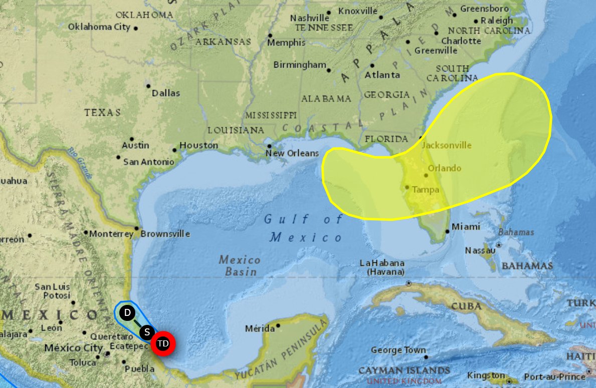
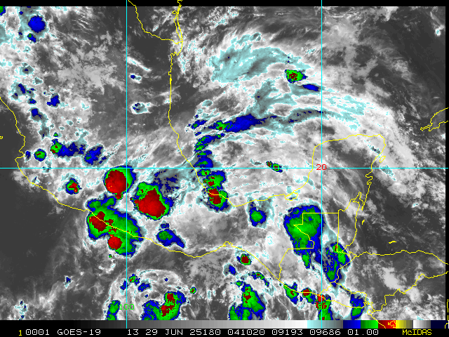
Tropical Depression 2 is in the Bay of Campeche now, still forecast to become a minimal tropical storm before landfall in Mexico. Next name is Barry.
There is a new yellow area along the northeast gulf extending over Florida into the Southeast with a 20% chance to develop over the next 7 days. Even if nothing develops from it quite a bit of heavy rain, particularly the end of the week, will be found in much of central and northern Florida and Georgia/South Carolina, including the July 4th holiday.
4PM CDT Update 28 June 2025
Invest 91L has become our second Tropical Cyclone of the year in the Atlantic basin, set to best climatology by over two weeks as the depression is forecast to become Tropical Storm Barry before making landfall along the eastern Mexican coastline late Sunday night or Monday. A Tropical Storm Warning is now in effect for the Gulf coast of Mexico from Boca de Catan southward to Tecolutla.
Original Update
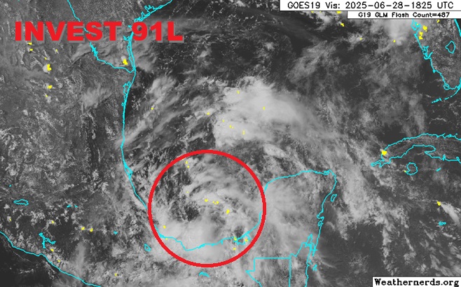
Base image credit: Weathernerds.org
Our second Invest-tagged feature of the 2025 Atlantic Hurricane Season is also likely to become our second named storm, unusual in getting back-to-back names out of the very first two Invests should this occur, and also unusual - although not as much so since 1995 - in that this would be well ahead of climatological average for our second name in this basin.
The next name on the list in 2025 is Barry. Interesting side note, the second named storm of 1995 was also Barry.
As of this new update, recon is presently sampling the area within and around Invest 91L and is also confirming that a well-defined circulation appears to be forming within the most recent blowup of convection. With this trend continuing, Tropical Storm Watches and/or Warnings may be issued for portions of the Mexican Gulf coast at any time.
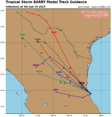
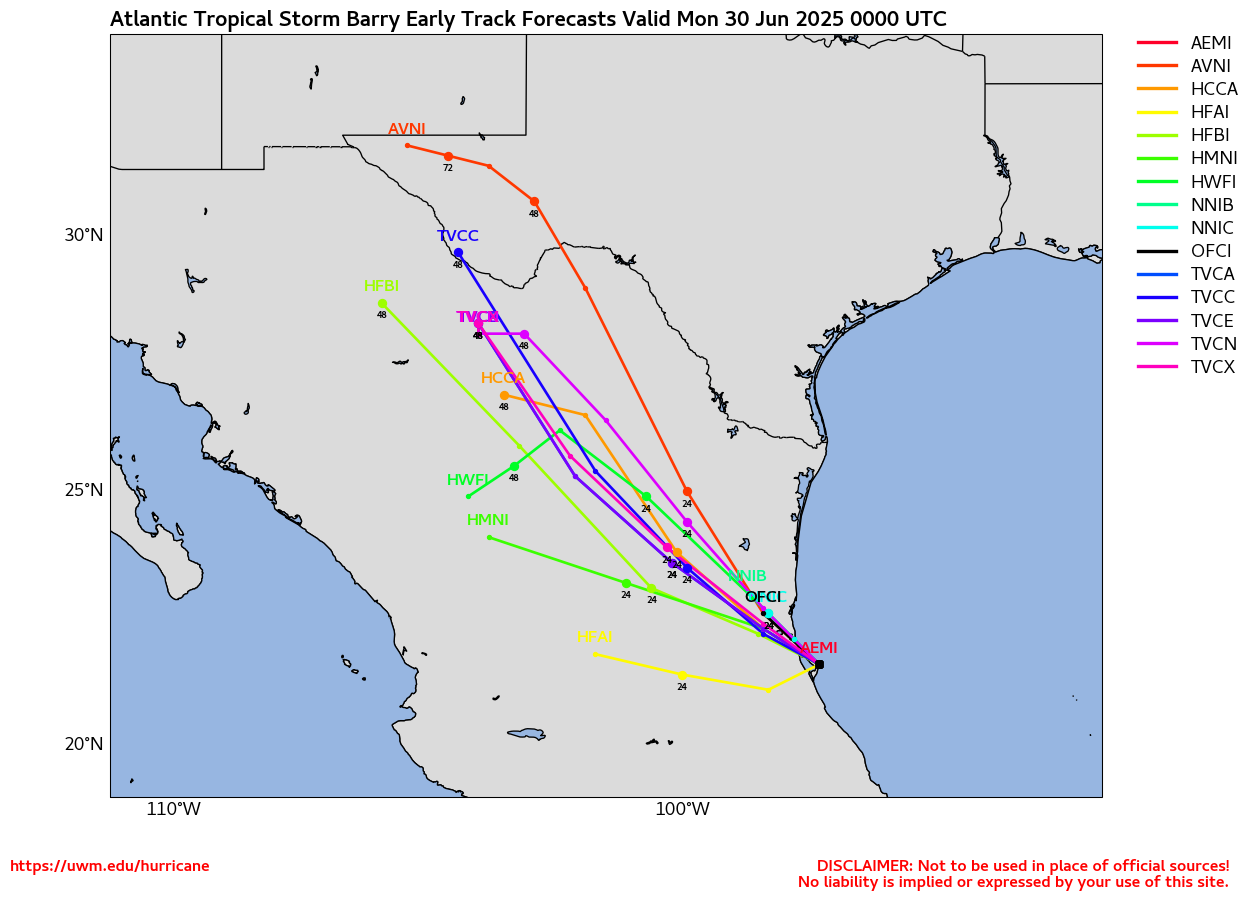
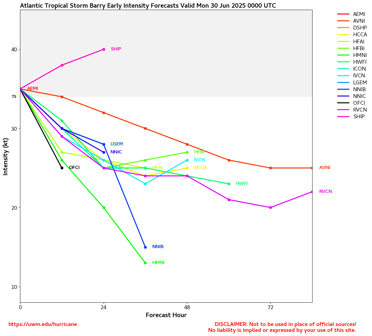
We do already have a Forecast Lounge up on this one to delve deeper into the models and personal best guesses: Barry Lounge
|
cieldumort
Moderator
Reged:
Posts: 2724
Loc: Austin, Tx
|
|
First VDM, rather weak, but closed and fairly well defined, much as expected. Would not be unreasonable for to begin advisories by 4PM CDT.
Product: Air Force Vortex Message (URNT12 KNHC)
Transmitted: 28th day of the month at 19:10Z
Agency: United States Air Force
Aircraft: Lockheed WC-130J Hercules with reg. number AF97-5304
Mission Purpose: Investigate first suspect area (flight in the North Atlantic basin)
Mission Number: 1
Observation Number: 04
A. Time of Center Fix: 28th day of the month at 18:36:30Z
B. Center Fix Coordinates: 19.28N 93.89W
B. Center Fix Location: 109 statute miles (175 km) to the NW (325°) from Villahermosa, Tabasco, Mexico.
C. Minimum Height at Standard Level: Not Available
D. Minimum Sea Level Pressure: 1012mb (29.89 inHg) - Extrapolated
E. Dropsonde Surface Wind at Center (Undecoded): NA
F. Eye Character: Not Available
G. Eye Shape: Not Available
H. Estimated (by SFMR or visually) Maximum Surface Wind Inbound: Not Available
I. Location & Time of the Estimated Maximum Surface Wind Inbound (Undecoded): NA
J. Maximum Flight Level Wind Inbound: From 223° at 20kts (From the SW at 23.0mph)
K. Location & Time of the Maximum Flight Level Wind Inbound: 25 nautical miles (29 statute miles) to the SE (144°) of center fix at 18:28:30Z
L. Estimated (by SFMR or visually) Maximum Surface Wind Outbound: Not Available
M. Location & Time of the Estimated Maximum Surface Wind Outbound (Undecoded): NA
N. Maximum Flight Level Wind Outbound: From 59° at 15kts (From the ENE at 17.3mph)
O. Location & Time of the Maximum Flight Level Wind Outbound: 24 nautical miles (28 statute miles) to the NW (315°) of center fix at 18:44:30Z
P. Maximum Flight Level Temp & Pressure Altitude Outside Eye: 22°C (72°F) at a pressure alt. of 304m (997ft)
Q. Maximum Flight Level Temp & Pressure Altitude Inside Eye: 23°C (73°F) at a pressure alt. of 304m (997ft)
R. Dewpoint Temp (collected at same location as temp inside eye): 21°C (70°F)
R. Sea Surface Temp (collected at same location as temp inside eye): Not Available
S. Fix Determined By: Penetration, Wind, Pressure and Temperature
S. Fix Levels (surface & flight level centers within 5nm of each other): Surface and 1,500 feet
T. Navigational Fix Accuracy: 0.02 nautical miles
T. Meteorological Accuracy: 9 nautical miles
Remarks Section - Remarks That Were Decoded...
Maximum Flight Level Wind: 20kts (~ 23.0mph) which was observed 25 nautical miles (29 statute miles) to the SE (144°) from the flight level center at 18:28:30Z
Sea Level Pressure Extrapolation From: Below 1500 feet
Remarks Section - Additional Remarks...
FIXED AT FL010 AGL
|
cieldumort
Moderator
Reged:
Posts: 2724
Loc: Austin, Tx
|
|
Upcoming flights into (Formerly 91L)
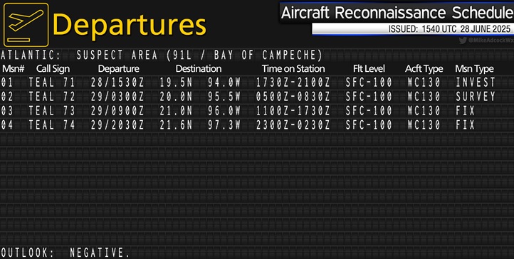
Image cr. Mike Adcock @MikeAdcockWx
|
MikeC
Admin
Reged:
Posts: 4835
Loc: Orlando, FL
|
|
This loop shows all the features now
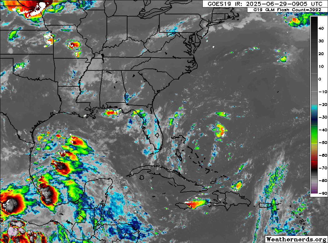
TWO in the Gulf, a low over the east Bahamas and the front in the midwest. Watching to see if development is likely or not for the yellow area over florida here.
|
cieldumort
Moderator
Reged:
Posts: 2724
Loc: Austin, Tx
|
|
Last leg of Mission 3: RADAR INDICATES FORMING EYEWALL ON SRN TO EAST SIDE
Quote:
Product: Air Force Vortex Message (URNT12 KNHC)
Transmitted: 29th day of the month at 17:13Z
Agency: United States Air Force
Aircraft: Lockheed WC-130J Hercules with reg. number AF97-5306
Tropical Depression: Two (flight in the North Atlantic basin)
Mission Number: 3
Observation Number: 21
A. Time of Center Fix: 29th day of the month at 16:40:00Z
B. Center Fix Coordinates: 20.59N 96.61W
B. Center Fix Location: 144 statute miles (231 km) to the SE (145°) from Tampico, Tamaulipas, Mexico.
C. Minimum Height at Standard Level: 1,497m (4,911ft) at 850mb
D. Minimum Sea Level Pressure: 1009mb (29.80 inHg)
E. Dropsonde Surface Wind at Center: From 290° at 12kts (From the WNW at 14mph)
F. Eye Character: Not Available
G. Eye Shape: Not Available
H. Estimated (by SFMR or visually) Maximum Surface Wind Inbound: 37kts (42.6mph)
I. Location & Time of the Estimated Maximum Surface Wind Inbound: 12 nautical miles (14 statute miles) to the SE (141°) of center fix at 16:36:00Z
J. Maximum Flight Level Wind Inbound: From 142° at 29kts (From the SE at 33.4mph)
K. Location & Time of the Maximum Flight Level Wind Inbound: 136 nautical miles (157 statute miles) to the E (90°) of center fix at 15:56:00Z
L. Estimated (by SFMR or visually) Maximum Surface Wind Outbound: 36kts (41.4mph)
M. Location & Time of the Estimated Maximum Surface Wind Outbound: 19 nautical miles (22 statute miles) to the NE (37°) of center fix at 16:46:30Z
N. Maximum Flight Level Wind Outbound: From 148° at 51kts (From the SSE at 58.7mph)
O. Location & Time of the Maximum Flight Level Wind Outbound: 22 nautical miles (25 statute miles) to the NE (38°) of center fix at 16:47:30Z
P. Maximum Flight Level Temp & Pressure Altitude Outside Eye: 16°C (61°F) at a pressure alt. of 1,524m (5,000ft)
Q. Maximum Flight Level Temp & Pressure Altitude Inside Eye: 18°C (64°F) at a pressure alt. of 1,521m (4,990ft)
R. Dewpoint Temp (collected at same location as temp inside eye): 4°C (39°F)
R. Sea Surface Temp (collected at same location as temp inside eye): Not Available
S. Fix Determined By: Penetration, Wind, Pressure and Temperature
S. Fix Level: 850mb
T. Navigational Fix Accuracy: 0.02 nautical miles
T. Meteorological Accuracy: 3 nautical miles
Remarks Section - Remarks That Were Decoded...
Maximum Flight Level Wind: 51kts (~ 58.7mph) which was observed 22 nautical miles (25 statute miles) to the NE (38°) from the flight level center at 16:47:30Z
Remarks Section - Additional Remarks...
RADAR INDICATES FORMING EYEWALL ON SRN TO EAST SIDE.
|


 Threaded


