cieldumort
Moderator

Reged:
Posts: 2639
Loc: Austin, Tx
|
|
A wave that has recently entered the far eastern Tropical Atlantic well south-southeast of the Cabo Verde Islands is more likely than not to track underneath a building area of high pressure left in the wake of a recurving Lorenzo and potentially track much farther west and develop in the Atlantic basin than most have done this year.
Conditions for development in the Main Development Region (MDR) this week and into next look markedly more favorable than they have throughout the bulk of this season, with abundant instability, rising motion, less dry air, and a forecast of less shear.
Despite it being mid-October, this year, like last, is trending back-loaded. If conditions for this wave play out as forecast, it could become a named storm approaching the Caribbean later this week into next. As such, we are starting a Lounge on this disturbance at this time.
No Invest tag yet and not yet mentioned in the
More details to come
This wave, now nearing the Caribbean, has been Invest tagged 98L today and the title has been updated accordingly.
2025-10-18 12:00 11.7N 49.9W 30 KTS
Ciel
Edited by cieldumort (Sat Oct 18 2025 01:02 PM)
|
Owlguin
Weather Hobbyist
Reged:
Posts: 77
|
|
Thanks. Both main models seem to be picking up on this and developing it into a pretty strong storm. Plenty of time to see how that plays out.
|
TanukiMario
Registered User
Reged:
Posts: 5
|
|
Thanks. I'll be following this one.
|
cieldumort
Moderator
Reged:
Posts: 2639
Loc: Austin, Tx
|
|
10-15-0z model runs out to 180 hours (7.5 days)
Models are increasingly holding off development of this wave until it just approaches, and more so, already well into, the Caribbean, sometime next week.
In sharing these, it is worth noting that 2025 has been a very challenging year for the models and forecasters, so much should be taken with a helping of salt.
Of all the models, the Google DeepMind GDM-FNV3 (Google Deep Mind's newest ensemble machine learning weather model, optimized for cyclones) has really been outstanding in terms of track and intensity for certain, and a cursory glance at how it has handled issues of TC genesis/no genesis, also a very good performance. At the other end, the has spun out so many phantom Caribbean TCs (usually of the CAG variety) this year, it is seriously at risk of becoming the little boy that cried wolf for when one actually does form, eventually, some month, some year, maybe this, maybe next.
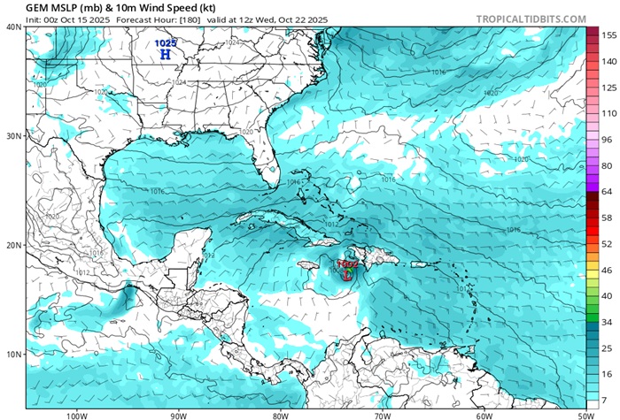
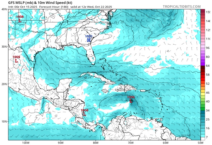
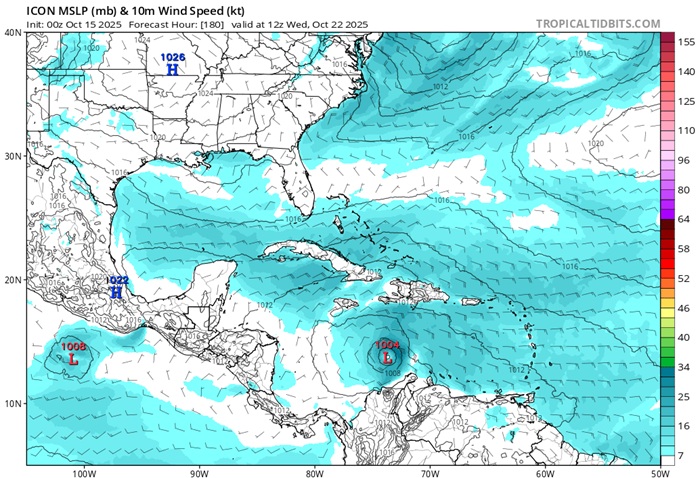
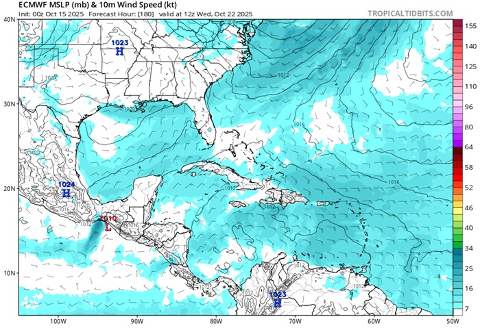
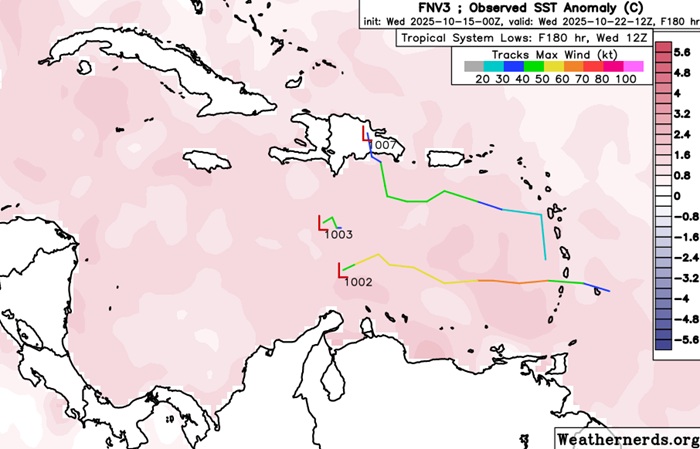
All in all, this is a strong signal for TC genesis in the Caribbean by the middle of next week. TCs that are in the Caribbean nearly always make a landfall, and often more than once. Additionally, this part of the basin has not yet been tapped of its potential, with very warm waters extending to exceptional depths.
|
MikeC
Admin
Reged:
Posts: 4805
Loc: Orlando, FL
|
|
Mixed model support on this system, worth following, but odds and climatology are still stacked against anything developing, or if it does staying away from any major landfall events. Key indicators, consistency in ensembles (particularly euro and google deep mind) and it's ensembles are showing lots of development potential, but the others aren't. Something may happen, but those in the Caribbean, Central America and the Yucatan Peninsula seem to be the most likely ones in the long range.
I.e. monitor, but not really concerned.
|
CFHC

Reged:
Posts: 194
Loc: East Central Florida
|
|
puts it over Haiti as a major. Euro and Google put it into Central America then bends back over Florida from the west coast in about 2 weeks.
Not too concerned yet, but in monitor mode.
|
Robert
Weather Analyst

Reged:
Posts: 370
Loc: Southeast, FL
|
|
...
|
cieldumort
Moderator
Reged:
Posts: 2639
Loc: Austin, Tx
|
|
Possibly the best model ensemble this year is the Google DeepMind, and it is not a bad one to give some credence to for as far out as 10 days.
Today's most recent 240 hour (10 day) outlook from the DeepMind continues to show a sizeable number of its ensemble members developing this wave in the Caribbean, with most of these then also showing a near collapse of steering currents, with the forecast future cyclone meandering about for a bit. Beyond ten days this model does show more of them moving the system, but beyond ten days is also pushing the capabilities even for this excellent model.
|
cieldumort
Moderator
Reged:
Posts: 2639
Loc: Austin, Tx
|
|
A collection of 10/17/0z globals out at 168 hours (a week out) from initialization strongly suggests development is possible if not likely in the Caribbean, with earlier development favoring a stronger-sooner cyclone that runs into the eastern Greater Antilles, heading, presumably, out to sea, whereas a delayed-weaker system might head for the western Caribbean, ultimately of concern for other locations.
|
cieldumort
Moderator
Reged:
Posts: 2639
Loc: Austin, Tx
|
|
Tonight's 0z hurricane models seem to be losing the vortex, if they even capture one. This could be one of the rare times where the globals do a better job, at least for now. All models should perform much better once recon missions begin, but so far, none have been tasked.
Looking at tonight's 0z "Big Three" globals ten days out highlights the unanimity of the globals that 98 will develop once in the Caribbean. From there, where it goes, is far less certain. Should 98L find itself in the central to western Caribbean mid/late next week, steering currents could even collapse.
10/19/0z EURO, CANADIAN, AMERICAN out to 240 hours
|


 Threaded


