cieldumort
Moderator

Reged:
Posts: 2715
Loc: Austin, Tx
|
|
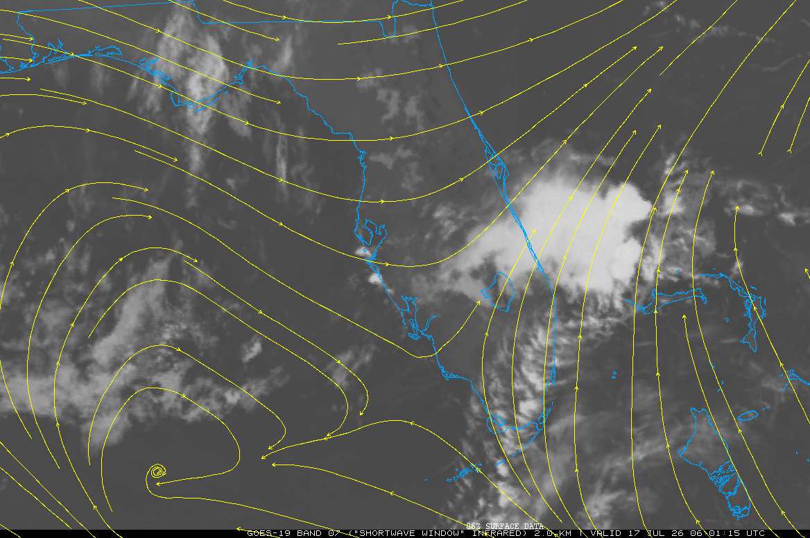
An area of mid-level low pressure appears to be developing over Florida as we head into Friday. Models increasingly also expect a surface low to form, at least once enough of the system has meandered into the eastern Gulf. More and more of the most recent runs, including several of the high-quality Google DeepMind and other machine-learners, spin up a tropical or subtropical cyclone early-mid next week, maybe even sooner.
As can be seen in the image above, this low is forming from the favorable interaction of sandwiching between two areas of high pressure, with the resulting cyclonic flow between them tightening up.
The background state for development includes the analyzed in a favorable Phase 8, and very warm gulf waters. While a pronounced El Niño is now underway in the Pacific, home-grown systems of this sort are always a valid concern, even during strong El Niño years.
Given the somewhat favorable environment for development, that there continues to be an upswing in the number of models and ensembles developing a nameable cyclone, and the fact that anything that forms in this region would be instantly landlocked right on the doorstep of the United States, we are starting a Lounge on this potential Invest. Should this Area of Interest get Invest-tagged, the title will be updated accordingly. This could happen as soon as later today or over the coming weekend.
Even if a named storm does not form, this system is likely to be yet another rain and flood maker. All gulf states from Florida to Texas may want to monitor this feature closely.
|
cieldumort
Moderator
Reged:
Posts: 2715
Loc: Austin, Tx
|
|
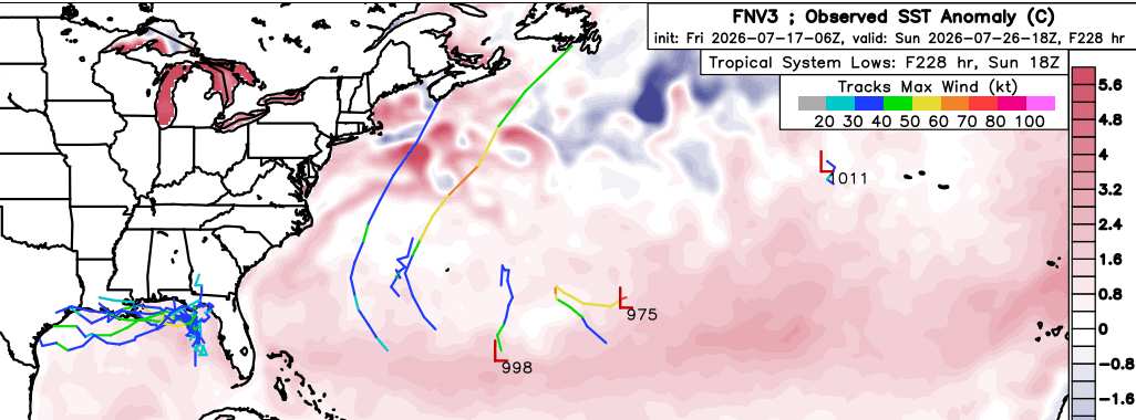
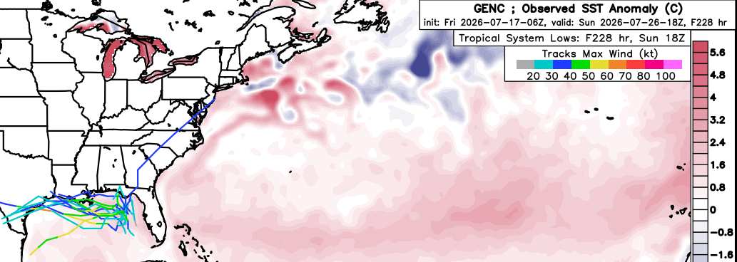
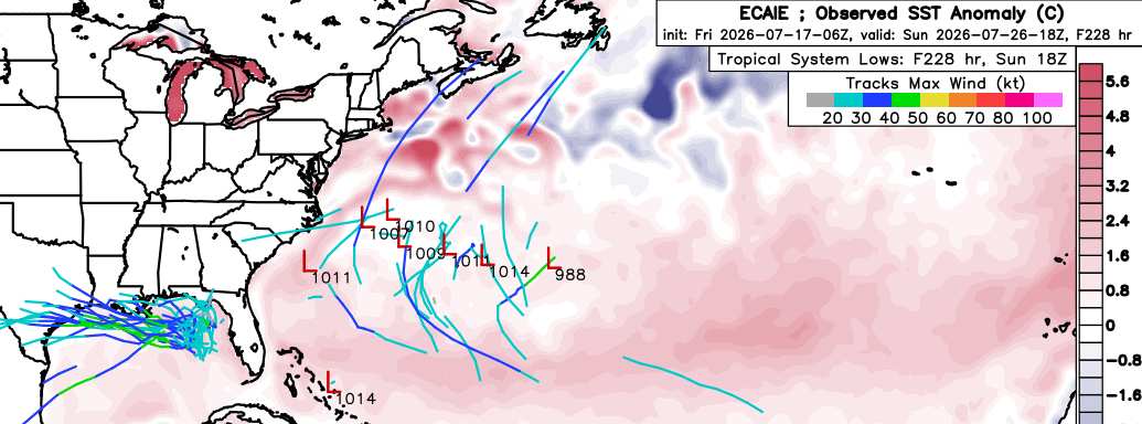
Some machine learning ensemble runs (most recent 06Z).
The most recent runs of the individual members that actually do develop this system into a quasi-tropical or fully tropical cyclone almost unanimously drive it westward. It is worth noting that this may flip-flop back to tracking east again, but a lot seems to hinge on where genesis ultimately occurs, which is still a known unknown.
Google DeepMind FNV3
Google DeepMind GENC
European Centre for AI Excellence
|
cieldumort
Moderator
Reged:
Posts: 2715
Loc: Austin, Tx
|
|
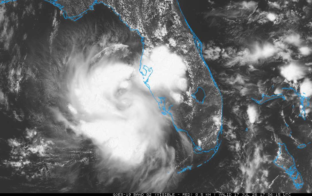
Tightening mid-level circulation and deeper convection is located just offshore.
This is not yet a tropical storm, and a consistent circulation is not yet at the surface, but this closed low aloft is rapidly attempting to build down to the surface today.
|
cieldumort
Moderator
Reged:
Posts: 2715
Loc: Austin, Tx
|
|
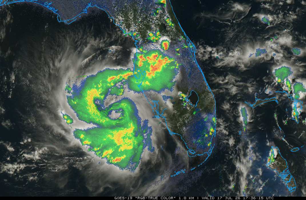
An Invest tag already seems appropriate
NHC has increased their bid from 20% to 30%, but this could be conservative.
|
JMII
Weather Master

Reged:
Posts: 548
Loc: Cape Coral & Margate, FL
|
|
Just checked the Tampa radar and its spinning out there due west of my place in Cape Coral.
--------------------
South FL Native... experienced many tropical systems, put up the panels for:
David 79 - Floyd 87 - Andrew 92 - Georges 98 - Frances 04 - Wilma 05 - Matthew 16 - Irma 17
Lost our St James City rental property to Ian 22
|
cieldumort
Moderator
Reged:
Posts: 2715
Loc: Austin, Tx
|
|
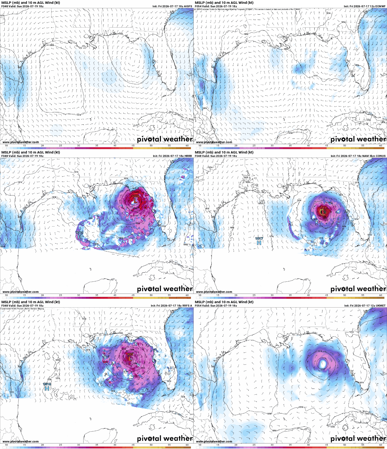
Most recent runs of Globals and also some CAMS (Convection Allowing Models) for 18Z Sunday. The Globals are uniformly on the tamer side, CAMS mostly developing, but CAMS do also have an inherent convective bias that can often overdo tropical systems (NAM infamously). Nonetheless, the CAMS probably are also signaling the upper-bound potential of this system for 18Z Sunday (roughly 40-48 hours out from now).
Today's midday increased their bid to 10% within 48 hours and 30% within 7 days, indicating that they still believe the best shot for tropical cyclone genesis may wait until next week.
|
Keith B
Weather Hobbyist
Reged:
Posts: 60
Loc: FL, Orange County
|
|
Tropical Weather Outlook
NWS National Hurricane Center Miami FL
800 PM EDT Fri Jul 17 2026
For the North Atlantic...Caribbean Sea and the Gulf of America:
Northern Gulf of America and near Florida:
Showers and thunderstorms over the eastern Gulf of America and
portions of the Florida Peninsula are associated with an upper-level
low and a surface trough. Surface observations indicate that
pressures are high in the area and that currently there are no signs
of a surface circulation. However, some gradual development of this
system is possible while it meanders northward, bringing heavy rain
to portions of the Florida west coast during the next several days.
* Formation chance through 48 hours...low...10 percent.
* Formation chance through 7 days...low...30 percent.
--------------------
Keith Boyer N4TRN
Orange County ARES
Asst. Emerg. Coord. (AEC) Skywarn Orange County, FL
http://www.ocares.org/
|
cieldumort
Moderator
Reged:
Posts: 2715
Loc: Austin, Tx
|
|
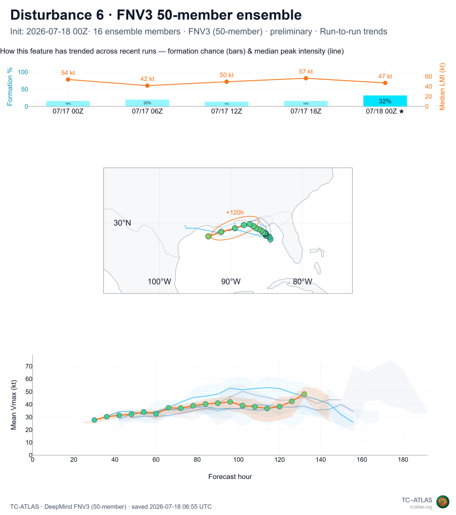
7/18/0z run of 50-member FNV3 ensembles has seen a significant rise in the percentage of ensemble members developing this system into a tropical storm (at least 34 KTS) from prior runs. These are only members that have attained tropical storm status, so hypothetically, there could be an implied greater odds of this disturbance becoming at least a TD (unnamed tropical cyclone).
Credit: TCatlas.org
|
cieldumort
Moderator
Reged:
Posts: 2715
Loc: Austin, Tx
|
|
Also an overall upswing with tonight's 0z runs of the Globals and CAMS (7/18/06z HRRR run shown here to keep time stamps all consistent for 06Z Monday 7/20).
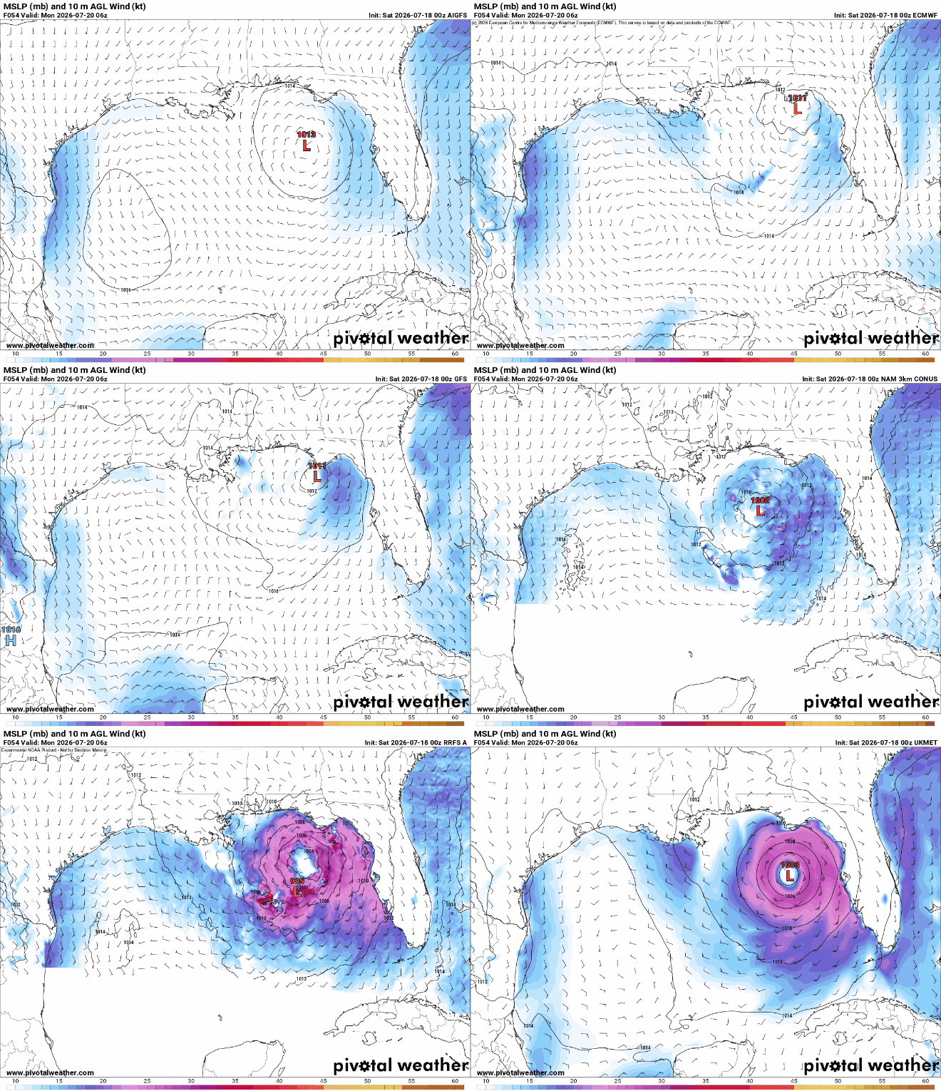
Most recent ensembles suggest about a slim but legitimate chance that the system could find itself a sweet spot and really take off, with 6 out of 50 members strongly advertising hurricane potential.
|



 Previous
 Index
Index
 Next
Next
 Threaded


 Edit
Edit
 Reply
Reply
 Quote
Quote


