CoconutCandy
User

Reged:
Posts: 245
Loc: Beautiful Honolulu Hawaii
|
|
Interesting discussion simmering here. And what a very interesting storm we have!
Classic case of (attempted) tropical cyclogenesis on the trailing end of a decaying frontal boundry. I've watched this storm sprout up, like many of us, from it's inception, as its parent front moved off the atlantic coastline a few days ago.
And while it certainly has been looking rather impressive the past day or so, it's also true that "appearances can be deceiving".
First, here's a few bits & snips from *Yesterdays* posts on this interesting system from Raymond, Rodney, Hugh and others:
Quote:
Part of Raleigh NWC forecast discussion:
MEANWHILE SUGGEST THAT THE SYSTEM MAY GAIN SOME SUB-TROPICAL CHARACTERISTICS AS IT DEPICTS A WARM CORE AT 850MB BY THIS EVENING INTO THU.
This was the NWS thinking, based on the , as of yesterday morning. But I don't think these exact figures were attained. Instead of a strong warm core developing at 850 mb by last evening, as the had forecast, I believe we have only a shallow 'surface' warm core thus far, but steadily improving in that department, which I will get to in more detail shortly.
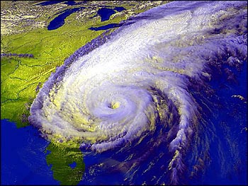
The the casual eye, the low now spinning offshore certainly *looks* like a hurricane, or at least like some kind of tropical storm.
Quote:
NHC has just issued STDS and I think that 'Kyle" has already formed, off of NC coast, ... either sub-tropical or tropical. In fact IMHO I think will start issuing advisories before recon can get there.
...
Yes, 94L could become Kyle ... I see an "eye-like feature" forming in the center of 94L!
...
Looking at the long-range Wilmington, NC, radar... I'd have to say 94L looks like it is closer to tropical than the reports. ... there is convection building near the LLC, and the radar presentation is improving. To me, if it looks like a hurricane, why not call it one, particularly when hurricane conditions are onshore?
...
NHC stated the following...
THE LOW IS PARTLY RESPONSIBLE FOR AN AREA OF WINDS TO HURRICANE FORCE WELL TO THE NORTH AND NORTHWEST OF THE CENTER.
So why not start advisories? It would appear this meets sub-tropical requirements at least ...
Interesting observations and very good questions. It's a combination of the old "appearances can be deceiving" on the one hand, and strict criteria for cyclone classification on the other.
But the real key in 94L's attempted tropical transition is the requisite development of the all-important warm core.
Quote:
... LIGHTNING ACTIVITY HAS GRAVITATED MORE TO THE CENTRAL CORE OF THE DEVELOPING SYSTEM ... THERE ARE INDICATIONS THAT THE SYSTEM COULD BECOME WARM CORE ...
...
94L is a bit more complex, it seems to be warm core right now, at least according to phase analysis. ... and the frontal zone (now) appears to be breaking down, which would give the system a much stronger case for being considered tropical / subtropical.
...
As states, 94L looks to be essentially a well-developed and tightly-wound coastal "LOW" that is in the process of acquiring some (warm core) tropical characteristics.
And from today's posts, just recently ...
Quote:
Have a vort that came in for 94L a little more supportive of naming it. 94L has developed a shallow warm core, and appears to be bringing in its radius of maximum sustained winds, while also exhibiting a little bit of banding-like structures around the center of circulation.
Excellent recap of the data collected from the recent recon mission into the storm. So, there are now definite trends, unlike yesterday, that tropical transition may now be well underway.
The visual sat. loops are showing gradually deepening convenction that is now tightly wrapping *all* the way around a relatively clear 'eye-like' formation, which presumably has led to the development of the 'shallow warm core' feature mentioned in the recon vortex message. And ...
Quote:
Long range Wilmington radar shows an almost large "eye" like feature present, that I don't think was there before. It also ... is moving or soon will be moving over the relatively warmer waters of the gulf stream.
Which brings me to the crux of the matter. The development of the warm core. It's this innermost convection that will 'make or break the case' for tropical or sub-tropical transition. Because it's precisely these thunderstorms with will, under the proper conditions, lead to the development (formation) of the tropical warm core.
And this ties in well with the question ... "Could somebody please point me to a good (basic) definition of what a system needs to do to be considered , subtropical or tropical?"
Above all, to be classed as a *true* tropical system, you need for the storm to have a 'warm core', relative to it's surroundings, through a deep layer of the atmosphere.

And so far, this just hasen't happened. But it now appears to be (finally) taking place as the LLC center is just beginning to move over the warm gulf stream waters.
These warmer waters will result in stronger thunderstorms, and more of them which, when acting in an organized fashion as they are now, and over time, will will release such a tremendous amount of latent heat of condensation, that it will actually *warm the entire atmosphere* over hundreds of square miles, and a bona-fide tropical cyclone is formed.
Although the wrapping we've seen previously certainly *looks* impressive, especially on the visible loops, the IR and Water Vapor loops tell a different story:
Until quite recently, this inner convection hasn't been partucullary impressive and certainly not very deep, as shown by the relatively warm cloud tops (compared with 93L), and the water vapor imagery suggests that not very much vertical transport of moisture (deep convection, with it's attendant latent heat) has occured yet, until quite recently.
Also, until recently, the doppler returns out of Wilmington, although suggesting the formation of a ring-like feature, have not been especially strong, either. And most of the deeper storms seem confined to the NW semi-circle.
But now, that all seems to changing, and quite rapidly, too. The warmer waters of the Gulf Stream now appear to be imparting better 'fuel' (has to do with higher vapor pressure) for the increasingly organizing thunderstorms, and as more and deeper convection continues to develop, the result will surely be the formation of the infamous warm core and an 'upgrade' to at least subtropical status, if not 'true' tropical transition sometime before landfall.

Keep one eye on the doppler radar for stronger and 'thicker' echo returns and the other on IR cloud top temps for dramatic cloud top cooling (especially after sunset, with the onset of the diurnal convective max cycle) and I think we will be witnessing tropical cyclogenesis right before our very eyes! Will we be having a landfalling 'Laura' ? Down to the Wire!
Edited by CoconutCandy (Thu Sep 25 2008 04:47 PM)
|
danielw
Moderator

Reged:
Posts: 3527
Loc: Hattiesburg,MS (31.3N 89.3W)
|
|
Looks to be trying hard to close off the wide center. Movement still up for grabs.
Puerto Rican disturbance still hanging on to marginal inprovement over the last few days.
Eastern cool front should/ could spell the end of some of the warmer SSTs. 
|
sailor
Verified CFHC User
Reged:
Posts: 11
Loc: cape cod
|
|
Current Recon Mission is a NOAA aircraft and is labeled Mission 9 into "KYLE" and is headed to 93L. TPC doesn't want to name the NC storm. The last AF Recon even noted the eye but TPC doesn't want to admit that this has a warm core and they have been sleeping at the switch.
Edited by sailor (Thu Sep 25 2008 04:39 PM)
|
Lee-Delray
Weather Master

Reged:
Posts: 429
|
|
The has Kyle listed
|
Thunderbird12
Meteorologist
Reged:
Posts: 644
Loc: Oklahoma
|
|
Kyle is the storm north of Puerto Rico (93L), not the low pressure system off of the NC coast.
Kyle will most likely stay east of the U.S., but it should be noted that both the and UKMET bring it over the Cape Cod area. Official forecast brings it to a minimal hurricane at its peak. Kyle will likely remain a lopsided system with most of the adverse effects to the east of the center.
Edited by Thunderbird12 (Thu Sep 25 2008 04:46 PM)
|
metwannabe
Weather Hobbyist

Reged:
Posts: 92
Loc: NC
|
|
The steeing layer would maybe suggest that 94L would move a little more northward then forecasted.
http://cimss.ssec.wisc.edu/tropic/real-time/atlantic/winds/wg8dlm2.html
It looks like in last radar loops it is moving slowly north. (Of course, whether it moves n/nnw/nw/w pretty much irrelevant except for those within couple hundred miles of center")
Local met just stated that winds along the outerbanks have lessened some today because part of the system broke off and moved north, leaving a more concetrated area of rain/wind near NC/SC border. Does this mean it is finally detaching itself from the frontal system, in its last ditch effort to be classified?
--------------------
Fran, Bertha, Dennis & Floyd (Tag Team)
|
CoconutCandy
User

Reged:
Posts: 245
Loc: Beautiful Honolulu Hawaii
|
|
Been watching closely for hours now, in 94L's bit to attain tropical or at least sub-tropical status.
Pluses in it's favor:
As viewed with Water Vapor Imagery, the dry air intrusion previously working its way into the very center has abated, and a very narrow 'channel' of dry air has been shunted well to the north of the center of curculation.
This will make it much easier for the inner core thunderstorms to build to greater heights and release their copious loads of moisture into the mid and upper levels, helping to establish the all-important warm core discussed above. Remember: Unless that warm core is established, this system will remain 'just another low' off the coast, albiet an interesting one
Also, the inner ring of convection does appear to be stronger and organizing itself better now. Earlier, the most intense bands in the NW quad had swept ashore, and the remaining weaker bands appeared fragmanted and elongated east-to-west. I thought it had lost it's bid.
But since then, newer bands have developed with a smaller radius, and the system does indeed appear to moving nore northward.
Which is another plus. A few hours ago, when the storm appeared to moving NW or even WNW, I thought it would 'run out of room' before tropical transition could complete.
But on a more northerly trajectory, it would allow the center of circulation to linger a little longer over the warm gulf stream, and picking up all that warmth and moisture.
Finally, as the area enters nighttime, the usual 'diurnal convective max' may provide just the additional 'umph' to the inner thunderstorms, to really warm that core in earnest, quite possibly pushing the low over the 'Tropical' threshold criteria to a landfalling 'Laura'. These next 6-18 hours will be crucial in it's bid for cyclogenesis. Laters.
|
metwannabe
Weather Hobbyist

Reged:
Posts: 92
Loc: NC
|
|
OK I understand all the definitions of tropical/sub-tropical, etc... But this has got to be "best" looking non-tropical low pressure system I have ever seen.
--------------------
Fran, Bertha, Dennis & Floyd (Tag Team)
|
Raymond
Weather Guru
Reged:
Posts: 112
Loc: Germany
|
|
94 L (may be Laura) makes landfall near the same spot Hanna made landfall. The radar representation is more like the one of a tropical/subtropical storm and the core has aquired some warm characteristics. My be qualifies this storm as subtropical/tropical in an analysis after the season! Winds are near hurricane force in any case!
|
scottsvb
Weather Master
Reged:
Posts: 1184
Loc: fl
|
|
People in Florida to even Biloxi need to start paying attention to the BOC and southern gulf over the weekend. A low presure area is developing and I have a feeling this will be a pretty strong Tropical Storm when it comes into the NE GOM. This system will have a shear zone to it, but it will be moving NE along with the shear zone, so anotherwords, it wont hamper this too much, though most of the winds and rainfall will be near the center and to its east. Right now we are looking at possible TD by Sunday and TS by Monday. Wont make a landfall forecast yet cause its too early, Ill post that in the forecast lounge. Right now I give this system a 50% chance of developing, 30% of being a TS by late Monday or Tuesday and 20% of a weak hurricane...but whats weak?
|
Thunderbird12
Meteorologist
Reged:
Posts: 644
Loc: Oklahoma
|
|
Hurricane watches have been posted for the coast of Maine as Kyle approaches from the south.
|
Hugh
Senior Storm Chaser
Reged:
Posts: 1060
Loc: Okaloosa County, Florida
|
|
Quote:
People in Florida to even Biloxi need to start paying attention to the BOC and southern gulf over the weekend. A low presure area is developing and I have a feeling this will be a pretty strong Tropical Storm when it comes into the NE GOM.
There is nothing in the BOC. No Invest, nothing mentioned in the ...in fact, there is not a single cloud.
There are some clouds in the extreme NW Caribbean, but they are not mentioned in the .
--------------------
Hugh
Eloise (1975) - Elena and several other near misses (1985) - Erin & Opal (1995) - Ivan (2004)
|
MissBecky
Weather Guru

Reged:
Posts: 112
Loc: Ft. Myers, FL
|
|
Quote:
There is nothing in the BOC. No Invest, nothing mentioned in the ...in fact, there is not a single cloud.
There are some clouds in the extreme NW Caribbean, but they are not mentioned in the .
Not yet there isn't. But I agree with Scott. Several of the models, including , , and are showing something approaching south or central Florida next week.
ETA: From the Tampa NWS Forecast Discussion:
A MID LEVEL TROUGH DROPPING
SOUTHEAST INTO THE MISSISSIPPI VALLEY WILL STEER A LOW PRESSURE AREA
OVER THE GULF OF MEXICO JUST NORTH OF THE YUCATAN PENINSULA TOWARD
WEST CENTRAL AND SOUTHWEST FLORIDA MONDAY NIGHT AND TUESDAY. THE
SURFACE LOW WILL MOVE EASTWARD ACROSS THE STATE LATE TUESDAY INTO
WEDNESDAY WITH A FOLLOWING COLD FRONT PUSHING SOUTH TO THE SOUTHERN
PART OF THE STATE. MODELS VARY ON TIMING AND STRENGTH OF THIS
BAROCLINIC SYSTEM BUT AT THE VERY LEAST THE SYSTEM WILL BRING BREEZY
CONDITIONS AND RAIN.
Edited by MissBecky (Sat Sep 27 2008 05:13 PM)
|
blizzardnut
Verified CFHC User
Reged:
Posts: 11
Loc: 42.3 N 71.7 W
|
|
Kyle (now a minimal hurricane) is really getting its act together, with what looks like a reasonable . The shear seems to have lessened and there is no dry air wedging in yet. Though it may only have minutes to go over the Gulf Stream, tomorrow might be an interesting day for places like Yarmouth, NS, especially as it's blazing northward. Wish I was up there... 
|
scottsvb
Weather Master
Reged:
Posts: 1184
Loc: fl
|
|
Yucitan disturbance looks really bad. I dont think this has a chance to develop, but we will see how it goes over the next day or 2.
|


 Threaded


