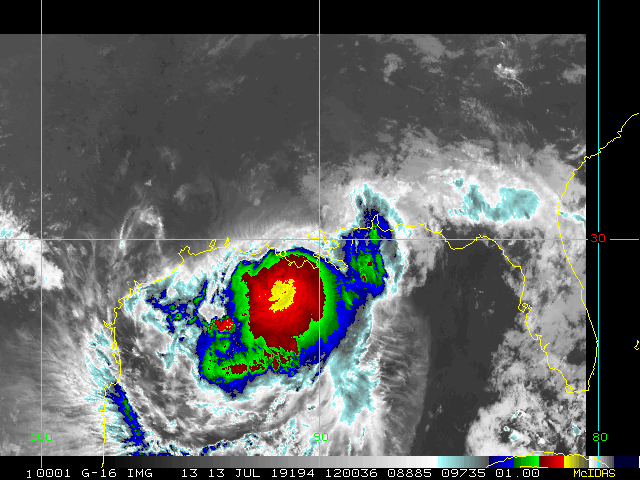
Update 10:30 AM ET June 4, 2019
A Tropical Low we have been following, Invest 91L, continues flirting with becoming a TD, but as of yet the basin looks very much early season. This feature has probably just 24-48 hours more to come together should it do so, depending on how much time it has left over water. Weaker = more likely to come ashore closer to Mexico/Texas. Stronger = more likely to come ashore Texas/Louisiana. Regardless of development, it will be a prolific rain-maker along its path. Showers and storms, some possibly heavy.
Update 1:30 PM ET June 2, 2019
Today's recon mission into 91L has been canceled, and the initial flight into the disturbance is now set for tomorrow instead, as 91L did not look organized enough this morning to warrant it.
During the past 12 hours or so, the tropical low has appeared to re-consolidate a bit more offshore, with some weak but noteworthy attempts at banding now evident. It is not entirely clear if this rejiggering more offshore is masking the same forward speed, albeit from a renewed location, but regardless, the system is now more over very warm water than not, and in a region of fairly favorable shear with a healthy upper-level anticyclone aloft. This will give 91L at least an extra day to develop.
From the current location, models suggest that over the next 72 hours track will begin bending more poleward. Interests in South Texas and Louisiana may want to start paying closer attention and listen to local mets and NWS offices for possible impacts in your immediate area.
Longer range speculation about 91L as well as various model runs are available in the 91L Forecast Lounge
-Ciel
Original Entry
Today marks the first day of the 2019 Atlantic Hurricane season, which has already had a short lived named storm, Andrea. come and go. And an area under watch near the Yucatan with a 30% chance for development.
Last year was most memorable for Hurricane Florence which strengthened into a major but weakened before landfall, but its slow movement caused tremendous flooding and storm surge along the Carolinas.
And hurricane Michael which started out in the west Caribbean and kept growing, making landfall as a Category 5 hurricane near Mexico Beach, FL. (Hurricane Michael upgraded to a Category 5 at time of U.S. landfall)
Several storms threatened Hawaii, and caused great rainfall on the Big Island, but as many storms do there, weakened and went away before landfall while the Kilauea eruption was winding down. Some of the eruption effects near Lelani Estates we captured on the USGS webcam recording here http://flhurricane.com/imageanimator.php?356
Once again we’ll be watching out in the Atlantic, and Hawaii if any storms threaten there.
On June 16th ,6:45pm in Tallahassee, FL at the Governer's square regal cinema our friend Mark Sudduth from Hurricanetrack.com will be having the Florida premiere that some of us may attend. It is open to the public (first come first serve, no charge)
The first regular outlook starts at 2AM on June 1st.
The names for 2019 are the following:
Sales Tax Holiday
This year Florida has a Hurricane Supply Sales Tax Holiday running May 31-June 6, 2019
This Includes reusable ice packs $10 or less.
$20 or less flashlights, lanterns, candles.
$25 or less: Any gas or diesel fuel container, including LP gas and kerosene containers
$30 or less: Batteries, including rechargeable batteries, excluding automobile and boat
Coolers and ice chests (food-storage; nonelectrical)
$50 or less: tarps, Visqueen, plastic sheeting, plastic drop cloths, and other flexible waterproof sheeting
Ground anchor systems, Tie-down kits, Bungee cords, Ratchet straps, Radios (powered by battery, solar, or hand-crank)
Two-way, Weather band
and Portable Generators Selling for $750 or less.


 Threaded


