CFHC

Reged:
Posts: 152
Loc: East Central Florida
|
|
11:20AM EDT 1 July 20214 Update
Beryl has made landfall on Carriacou Island as a still-intensifying upper-end Cat 4 with 150 MPH maximum sustained winds, still increasing, and central pressure of 950mb, still falling. It is possible that Beryl attains Cat 5 while still raking the southern Windwards this afternoon.
Ciel
8:00AM EDT 1 July 20214 Update
Recon confirms what satellite and radar have been suggesting. Beryl is back up to Category 4 with 130MPH winds, reintensifying into initial landfall somewhere around Grenada.
Grenada and the Grenadines are about to take a direct hit of this rare Major Hurricane. Preps to protect life should be rushed to completion.
Ciel
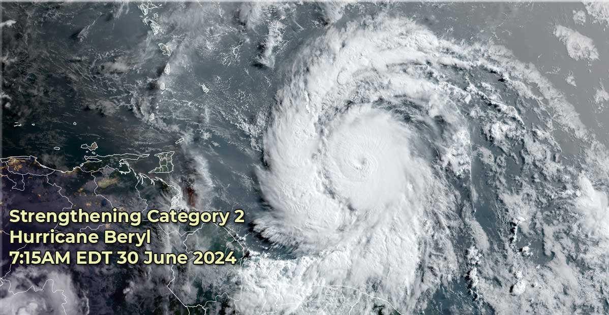
5:00PM EDT 30 June 20214 Update
Category 4 Beryl holding its own and expected to begin bringing life-threatening and catastrophic weather late tonight and Monday, as Beryl is expected to remain a Major Category 4 over the Windwards.
Elsewhere, Invest 94L has become our third official Tropical Cyclone of the year and is forecast to intensify into a Tropical Storm later this evening in the extreme southwestern Guf of Mexico.
Quote:
SUMMARY OF WATCHES AND WARNINGS IN EFFECT:
A Hurricane Warning is in effect for...
* Barbados
* St. Lucia
* St. Vincent and the Grenadine Islands
* Grenada
* Tobago
A Tropical Storm Warning is in effect for...
* Martinique
A Tropical Storm Watch is in effect for...
* Dominica
* Trinidad
* South coast of Dominican Republic from Punta Palenque westward to the border with Haiti
* South coast of Haiti from the border with the Dominican Republic to Anse d'Hainault
The government of Mexico has issued a Tropical Storm Warning from Cabo Rojo south to Puerto Veracruz.
Ciel
4:00PM EDT 30 June 20214 Update
Recon has been flying Invest 94L today and Advisories will likely be coming shortly.
Ciel
11:35AM EDT 30 June 20214 Update
Recon's most recent passes are finding surface winds that would support an update to Cat 4 shortly. If verified, once again this would be yet another "ahead of schedule" intensification.
Beryl may very well be making a run for Category 5 prior to reaching the Windwards. Those in its path should be rushing preparations to protect life and property. Catastrophic impacts may arrive within the next 18-24 hours.
Ciel
6:00AM EDT 30 June 20214 Update
Beryl is now forecast to become a Category 4 Hurricane when it crosses the Windwards islands, with the most direct impacts in the hurricane warning area, and particularly the Grenadine.
A serious situation is setting up for parts of these islands, those there should rush preparations as today is the last full day to get them complete.
Beyond this those in the cone should be monitoring, including Jamaica and the Cayman Islands. It is forecast to weaken somewhat once it hits shear in the Caribbean, but still forecast to be a hurricane then. Those in the Yucatan Peninsula also need to watch.
Also the area east of Beryl is now being tracked as invest 96L with a 70% chance to develop over the next 7 days.
94L has entered the Bay of Campeche and has a 50% chance to develop.
Recon is nearing Beryl and will have reports soon on just how strong it is, it may even be a major already.
8:30PM EDT 29 June 20214 Update
Beryl is now up to an 80 MPH hurricane and
Tropical Storm Warnings are now up for Martinique and Tobago.
Hurricane Warnings now join Barbados for St. Lucia. and St. Vincent and the Grenadine Islands and Grenada.
4:30PM EDT 29 June 20214 Update
Tropical Storm Beryl is now Hurricane Beryl and forecast to become a major hurricane with 120mph winds near the Windward islands. Hurricane Warnings are now up for Barbados. This is the farthest east that a hurricane has formed in the tropical Atlantic in June on record, breaking the old record set in 1933 by the 1933 "Trinidad Hurricane".
11AM EDT 29 June 20214 Update
Tropical Storm Beryl is now up to a 65mph storm and now forecast to become a Major hurricane as is crosses the Windward islands on Monday.
Hurricane watches are now up for Barbados, St. Lucia , St. Vincent and the Grenadine Islands, and Trinidad..
Tropical Storm Watches are up for Tobago and Martinique. .
Beyond this the track shifted a little left, but those in the cone, particularly Jamaica and the Cayman Islands should watch this system closely.
8AM EDT 28 June 20214 Update
Tropical Storm Beryl has strengthened into a 60mph Tropical storm, and expected to become a hurricane tomorrow.
Because of this Hurricane watches are up for Barbados. Other hurricane watches for islands west of Barbados may be issued later today.
For Barbados conditions likely will begin to deteriorate Sunday night and the closet approach during the day Monday. Beyond wind, extreme amounts of rainfall 3 to 6 inches (maybe more localized) in some areas. And some surge from 2 to 4 feet, especially on the eastern facing sides of the islands for those areas in or the right of the eye.
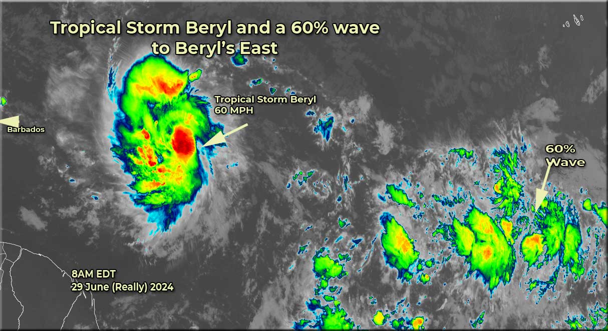
The area east of Beryl now has a 60% chance to develop, and those in the same islands as Beryl should continue to monitor that as well. Chris is the next name on the list. Also 94L has a chance to develop once in the Bay of Campeche, so Mexico should watch that.
Beryl is the strongest June tropical storm this far east in the tropical Atlantic on record. Recon is staged at St. Croix and will fly into Beryl tomorrow.
11:PM EDT 28 June 20214 Update
Tropical Storm beryl has formed from Tropical Depression Two . No watches or warnings for the islands have been issued yet, but likely will tomorrow. Those in the Windward islands of the Caribbean should be watching this system closely for Monday.
Beyond that the cone takes it toward Jamaica by Wednesday, but anyone along or near the cone should be keeping up with this system.
6:45PM EDT 28 June 20214 Update
In addition to newly-designated TD east of the Windwards, there are additional features in the Atlantic that are showing continued model support for development, which is not surprising given the unseasonably very favorable background state of much of the basin.
Closest to land already, we have now started a Lounge on Invest 94L in the northwest Caribbean 94L Forecast Lounge . Then behind TD , we are also monitoring two additional robust waves. Again, much more remiscent of the heart of a hurricane season than June or July.
Ciel
Original Update
Tropical Depression Two forms east of the Windward islands. Watches are likely for parts of the Windward islands overnight for Monday as a hurricane is forecast to arrive there then. Beyond that, those in the cone should pay close attention.
It's likely to be upgraded to Tropical Storm Beryl tonight or early tomorrow.
Beryl Lounge
Edited by cieldumort (Mon Jul 01 2024 11:19 AM)
|
MikeC
Admin
Reged:
Posts: 4570
Loc: Orlando, FL
|
|
TD#2 very likely to be upgraded to Beryl at 11PM Advisory as well as watches likely to start being issued.
|
cieldumort
Moderator

Reged:
Posts: 2346
Loc: Austin, Tx
|
|
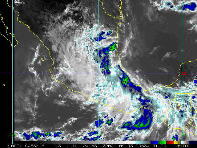
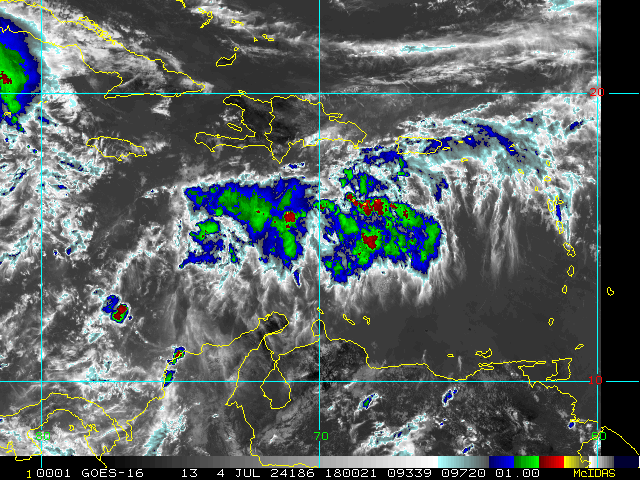
As of the June 29, 2024 11AM Advisory, the updated intensity forecast explicitly forecasts Rapid Intensification and brings Beryl up to Major (Cat 3+) before it even reaches the Windwards. For the time of year, this is unprecedented.
Just looking at hurricanes passing within 100 miles of Barbados this early in a season, Dr. Philip Klotzbach notes: "Only 2 hurricanes on record (since 1851) have been within 100 miles of Barbados prior to 1 August: Emily (2005) and Elsa (2021)"
Taking a look at the intensities and tracks of our two only analogs for this event:
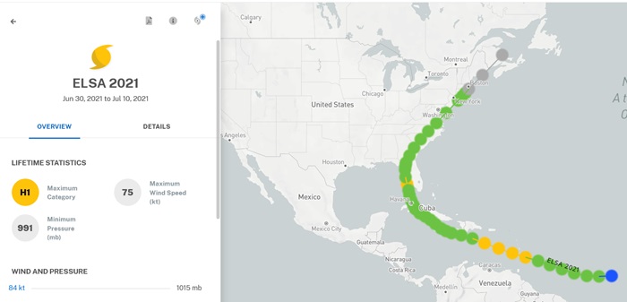
Above: Elsa (2021) passed through the Windwards as a Cat 1
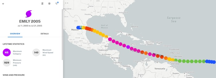
Above: Emily (2005) passed through the Windwards as a Cat 1
More seasonal 2024 analog tracking can be found here 2024 Forecast and Modeling Updates
|
cieldumort
Moderator
Reged:
Posts: 2346
Loc: Austin, Tx
|
|
|
MikeC
Admin
Reged:
Posts: 4570
Loc: Orlando, FL
|
|
Recon reports so far suggest Beryl is now a major hurricane. 8AM Advisory should be interesting.
Northwest side: 108 kt FL, 94 kt SFMR
Southeast Side: 101 kt FL, 107 kt SFMR
Pressure: 968.7 mb
reports still incoming
|
danielw
Moderator

Reged:
Posts: 3526
Loc: Hattiesburg,MS (31.3N 89.3W)
|
|
1030 AM EDT Monday July 1st.
Beryl appears to have completed the Eyewall Replacement Cycle and is back to a steady state storm.
.jpg)
Edited by danielw (Mon Jul 01 2024 10:28 AM)
|
cieldumort
Moderator
Reged:
Posts: 2346
Loc: Austin, Tx
|
|
|
cieldumort
Moderator
Reged:
Posts: 2346
Loc: Austin, Tx
|
|
The official upgrade to Cat 5 appears very near
Product: NOAA Vortex Message (URNT12 KWBC)
Transmitted: 2nd day of the month at 2:19Z
Agency: National Oceanic and Atmospheric Administration (NOAA)
Aircraft: Lockheed WP-3D Orion (Reg. Num. N42RF)
Storm Name: Beryl
Storm Number & Year: 02 in 2024 (flight in the North Atlantic basin)
Mission Number: 7
Observation Number: 20
A. Time of Center Fix: 2nd day of the month at 1:51:02Z
B. Center Fix Coordinates: 13.71N 64.59W
B. Center Fix Location: 339 statute miles (546 km) to the SSE (163°) from San Juan, Puerto Rico (U.S.).
C. Minimum Height at Standard Level: 2,623m (8,606ft) at 700mb
D. Minimum Sea Level Pressure: 940mb (27.76 inHg)
E. Dropsonde Surface Wind at Center: From 170° at 20kts (From the S at 23mph)
F. Eye Character: Closed
G. Eye Shape & Diameter: Circular with a diameter of 15 nautical miles (17 statute miles)
H. Estimated (by SFMR or visually) Maximum Surface Wind Inbound: Not Available
I. Location & Time of the Estimated Maximum Surface Wind Inbound (Undecoded): NA
J. Maximum Flight Level Wind Inbound: From 304° at 109kts (From between the WNW and NW at 125.4mph)
K. Location & Time of the Maximum Flight Level Wind Inbound: 7 nautical miles to the SSW (210°) of center fix at 1:49:22Z
L. Estimated (by SFMR or visually) Maximum Surface Wind Outbound: Not Available
M. Location & Time of the Estimated Maximum Surface Wind Outbound (Undecoded): NA
N. Maximum Flight Level Wind Outbound: From 143° at 157kts (From the SE at 180.7mph)
O. Location & Time of the Maximum Flight Level Wind Outbound: 10 nautical miles (12 statute miles) to the NE (45°) of center fix at 1:53:29Z
P. Maximum Flight Level Temp & Pressure Altitude Outside Eye: 12°C (54°F) at a pressure alt. of 3,056m (10,026ft)
Q. Maximum Flight Level Temp & Pressure Altitude Inside Eye: 22°C (72°F) at a pressure alt. of 3,056m (10,026ft)
R. Dewpoint Temp (collected at same location as temp inside eye): 7°C (45°F)
R. Sea Surface Temp (collected at same location as temp inside eye): Not Available
S. Fix Determined By: Penetration, Radar, Wind, Pressure and Temperature
S. Fix Level: 700mb
T. Navigational Fix Accuracy: 0.01 nautical miles
T. Meteorological Accuracy: 1 nautical mile
Remarks Section:
Maximum Flight Level Wind: 157kts (~ 180.7mph) which was observed 10 nautical miles (12 statute miles) to the NE (45°) from the flight level center at 1:53:29Z
|


 Threaded


