cieldumort
Moderator

Reged:
Posts: 2497
Loc: Austin, Tx
|
|
This post may get merged with the Invest 90L Forecast Lounge if warranted.
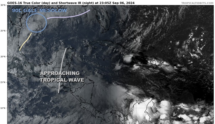
Above: Approaching Tropical Wave southeast of the south-drifting Mesolow and front.
Base image cr: Tropical Tidbits
A somewhat healthy tropical wave crossing the Yucatan this weekend and starting to peek out into the extreme southeastern Bay of Campeche is now highlighted by with 50% "Code Orange" development odds within the next 7 days (mostly focusing on the early to middle part of next week). As the wave is presently mostly over land, any meaningful development out of this feature is very unlikely until at least late Saturday at the earliest.
Invest 90L, which has now been dropped from the website but still exists tonight as a mostly non-tropical frontal mesolow, continues to be forecast by many models to interact with this approaching wave later this weekend to early next week. broadly focuses on the interaction of 90L's parent front itself with this wave.
With 90L having reconnected with the aforementioned front, this wave's interaction with the entire frontal boundary and not just a spinoff mesolow would likely have implications for where a TC (if one forms) tracks and how strong it will get. More time over water could give it more time to intensify, if all other conditions allow.
Sea Surface Temps in the Gulf are record high.
More details to come
The wave has been entering the extreme southern Bay of Campeche a bit ahead of schedule and has just been Invest tagged, 91L, and the title has been updated accordingly.
91L INVEST 07 SEP 2024 1300Z
Invest 91L is now a tropical storm force PTC SIX and could be named later today. The title has been updated accordingly. 9/8/24 3PM CDT
Ciel
PTC SIX has sufficiently organized to be classified as a tropical cyclone and with winds already at or above the threshold, is being upgraded to Francine and the title has been updated accordingly. 09 SEP 2024 1330Z
Edited by cieldumort (Mon Sep 09 2024 10:04 AM)
|
cieldumort
Moderator
Reged:
Posts: 2497
Loc: Austin, Tx
|
|
There are some signs that the approaching wave is becoming a bit sharper. It remains to be seen how it fares once it crosses into the Bay of Campeche, but early on at least, shear could be low and of course SSTs are exceptional.
Without going much into still murky details, here is a list of various 0z and 18Z model runs with notation as to whether they develop ("YES") something in the SW Gulf regardless of how (as noted in the original post, methods may include all on this wave's own, interaction with old 90L, interaction with the front, interactions with old 90L and the front, or old 90L itself), or if they don't ("NO"), or inconclusive (INC)
Time/Model/Develops?
0z : NO
0z : YES
0z ICON: YES
0z GDPS: YES
0z UKMET: YES
0z NAM: YES
0z RDPS: YES
0z GEFS: INC
0z SREF: NO
18z EPS: NO
18z -AIFS: YES
Models that do develop a TC in the Bay of Campeche largely expect it to track north and threaten Texas and/or Louisiana next week.
|
cieldumort
Moderator
Reged:
Posts: 2497
Loc: Austin, Tx
|
|
Invest 91L remains messy and things look as though they could go any number of ways, from never organizing enough all the way to strong hurricane. This shouldn't be a surprise given how oddly this entire season has been playing out.
As of 1AM CDT, 's latest assigns a 70% chance of 91L becoming a TC within 48 hours and 80% within 7 days. This seems very reasonable, but still does little to nothing to illuminate just how significant a TC. We should know a lot more once recon has spent some time in there tomorrow afternoon.
At present, the system we are tracking as 91L consists of two lobes tied to each other, while also starting to interact with an approaching former-90L, that swirl having largely separated from its parent front. So, there could soon even be three lobes interacting with each other.
Recent microwave passes argue for the eastern lobe of 91L to dominate, despite that the westernmost lobe, which is sporting a ball of very deep convection, could already be producing winds somewhere between 30 and 35 knots and is somewhat closed off at the surface.
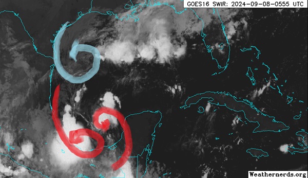
Light blue: Old Invest 90L non-tropical low
Red: The west and east lobes of Invest 91L
Base image credit: Weathernerds.org
As old 90L continues south and the eastern lobe of 91L already wants to track north as it is rounding Atlantic high pressure, the path of least resistance should be to eject to the north to northwest, possibly hooking around old 90L and getting pulled more to the left for a while. All of this speculation, but models generally want to bring the system inland anywhere from south of Brownsville, TX (generally weaker) to eastern Louisiana (generally stronger).
|
cieldumort
Moderator
Reged:
Posts: 2497
Loc: Austin, Tx
|
|
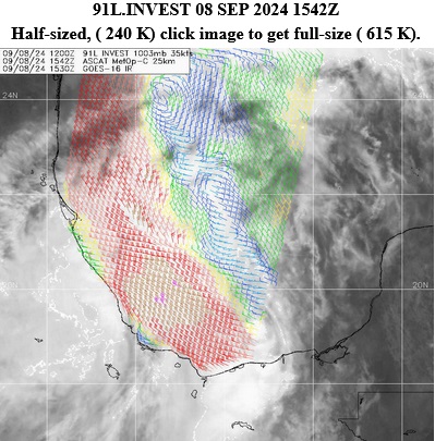
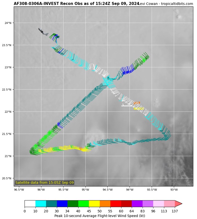
ASCAT from 1524z today showing that at that time Invest 91L remained largely a trof connected to x90L to its north-northwest
|
MikeC
Admin
Reged:
Posts: 4635
Loc: Orlando, FL
|
|
Six is looking like it's ready to take off later today, no dry air issues, shear isn't a problem, water temps high, outflow pretty decent, and obviously pulling itself together right now. Still think the current official forecast is too low, but a lot depends on exactly how the system lines up. I never like to see a strengthening setup like this if it's still strengthening at landfall. Gulf coast should really really watch this one.
|
Robert
Weather Analyst

Reged:
Posts: 366
Loc: Southeast, FL
|
|
The last couple of season have been Squandered by the National Hurricane Center
5 AM DIscussion, forming stages, not much evidence of banding, 50 mph winds measured by recon...
I look on sattelite and there is tones of evidence of banding features, it looks like a nice round blob with feeder bands coming in on the east wrapping around, high cirrus outflow..
But no just a potential cyclone..
I've watched what they name out in the pacific and they let stuff get named that they never even talk about on the atlantic side...
I have seen two systems so far this year that could have got a name a weak 40mph storm but no not this hurricane center director.
They don't care about science just insurance claims and not having to initiate emergency management...
They won't name it till it's almost a hurricane then everyone is all surprised when rapid intensification happens because it's already there , so they forcast it to all happen in the next 12 hours...
I am sick of watching Hurricanes now.. there is no reason to speculate watch or talk as it won't get a name till it's possibly gonna hit land or it's already a hurricane... so for God sakes go do something else with your life as this hole watching storms is dead as all you are going to end up if you keep watching.. go outside don't care about the weather enjoy your life.. the National Hurricane Center will warn you of impending economic loss and that's all you need to worry about...
Potential 6 is a Storm now a strong one, and will quickly become a hurricane because it's been a storm for over a day now
|
cieldumort
Moderator
Reged:
Posts: 2497
Loc: Austin, Tx
|
|
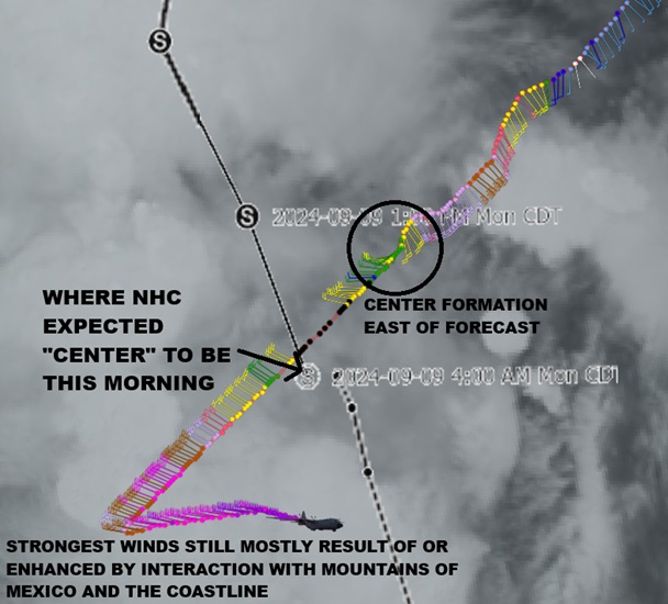
The third recon mission into SIX is in progress and the fledgling tropical cyclone may be jumping to the east. This location is actually not inside the very deep convection that IR satellite would imply.
1 min averaged winds so far are below tropical storm strength, but they have not yet sampled much of the very deep convection closer to the Mexican coastline. Much of yesterday's 40-60 MPH winds were actually the result of the barrier jet that is produced along the mountains of Mexico.
SIX may look mean and strong on infrared satellite, but under the hood remains a hodgepodge of several lobes and swirls and a trof axis that has been taking its time to congeal, but this morning does appear to be. I wouldn't expect a downgrade to TD with the 11AM, but based on what recon is actually finding under the hood, if this was their first mission it would probably be listed as a 35 MPH TD at this point.
As for SIX's future, it more likely than not will become a strong hurricane and possibly a Major. The official forecast of 80 MPH may be conservative, but OTOH much of the modeling rightly is indicative that the lumbering and large nature of the cyclone, especially after such a convoluted formation, could be slow to have the surface winds respond to the deepening and tightening low pressure.
As a reminder tho, a larger hurricane of any Saffir Simpson category can be quite destructive with surge and inland flooding oftentimes catching people by surprise who thought themselves safe from "only a category (fill in the blank)."
|
cieldumort
Moderator
Reged:
Posts: 2497
Loc: Austin, Tx
|
|
Models and the official forecast will be updated with this new information.
|
cieldumort
Moderator
Reged:
Posts: 2497
Loc: Austin, Tx
|
|
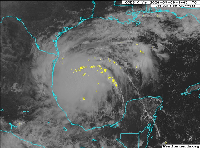
To Robert's point of banding evidence, we can now even track that out with the lightning strikes. Some strong thunderstorms in this early-stage tropical storm. Research has shown that lightning in banding like this is often a precursor signature to imminent strengthening. Good odds we may see RI over the next 24 hours.
|
cieldumort
Moderator
Reged:
Posts: 2497
Loc: Austin, Tx
|
|
Oh boy
Recon has just exposed a second, arguably stronger center, in the very deep convection northwest of the 10AM Advisory center, and frankly possibly associated with the extremely deep convection that blew up on what would probably have been the circulation of old Invest 90L.
This is a mess and why we should all be extremely hesitant to make any 'calls.' Should the center here take over, as it looks like it may, interests west of the center cone may be under the gun, and candidly the forecasts at this time are not what one should consider confident.
|
cieldumort
Moderator
Reged:
Posts: 2497
Loc: Austin, Tx
|
|
The 12Z hurricane model runs did alright with the present location and structure of what might already be a hurricane Francine. New recon has just departed that will be in the cyclone tonight and get an idea for how much it has strengthened. is estimating it to be up to 65 MPH with the 4PM CDT Advisory.
The tropical cyclone now has a solid core, even a nascent eye, and this will make future tracking and forecasts far easier for models and forecasters alike, but the benefit of having recon in the system as often as possible can not be overstated. Taken all together, model runs and forecasts from tonight on should be much more reliable.
|


 Threaded


