Current Radar or Satellite Image

Flhurricane.com - Central Florida Hurricane Center - Tracking Storms since 199531 Years of Hurricanes Without the Hype - Since 1995


A coastal storm could acquire tropical characteristics near the Mid Atlanitc later this week. Out near Hawaii, xTD15 forecast to redevelop. Lounges up on both.

Days since last Hurricane Landfall — US Any: 712 (Milton), US Major: 712 (Milton), FL Any: 712 (Milton), FL Major: 712 (Milton)
FlHurricane Atlantic Tropical Cyclone Tracking 🌀 Since 1995
30.8N -35.3W
Wind: 35MPH
Pres: 1011mb
Moving:
Present movement...wsw or 240 degrees at 9 mph...15 km/h
Click for Storm Spotlight
HypeScale:
2.50
0510
Communication
Storm Data
Content
Follow & Connect


General Discussion >> 2026 Forecast Lounge

Jump to first unread post. Pages: 1
cieldumortModerator
Moderator


Reged:
Posts: 2872
Loc: Austin, Tx
Modeled Wet Hybrid Cyclone off Mid-Atlantic
      #116257 - Sun Sep 20 2026 09:51 PM


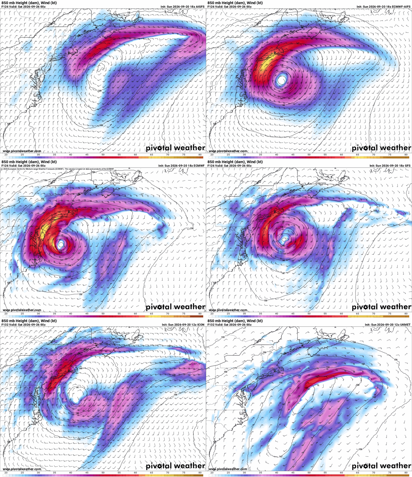
A number of models are increasingly keen on the formation of a hybrid wet Nor'easter to fully tropical and potentially wet Sandy-like hurricane forming off the Mid Atlantic late in the coming week and/or into the coming weekend. While NHC is not yet outlining this area, the signal is so significant and potentially serious (right now, lower odds but high ceiling on the impact scale) that we are opening up a Lounge on this forecast future cyclone, Invest TBD.

More to come.


Post Extras: Print Post   Remind Me!   Notify Moderator  
cieldumortModerator
Moderator


Reged:
Posts: 2872
Loc: Austin, Tx
Re: Modeled Wet Hybrid Cyclone off Mid-Atlantic [Re: cieldumort]
      #116258 - Sun Sep 20 2026 10:08 PM


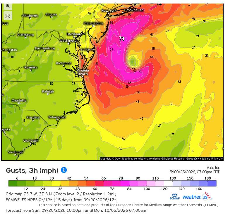
ECMWF Forecast gusts for Friday Sep 25 at 8PM EDT
Credits: Weather.US and ECMWF


Post Extras: Print Post   Remind Me!   Notify Moderator  
cieldumortModerator
Moderator


Reged:
Posts: 2872
Loc: Austin, Tx
Re: Modeled Wet Hybrid Cyclone off Mid-Atlantic [Re: cieldumort]
      #116259 - Sun Sep 20 2026 10:15 PM

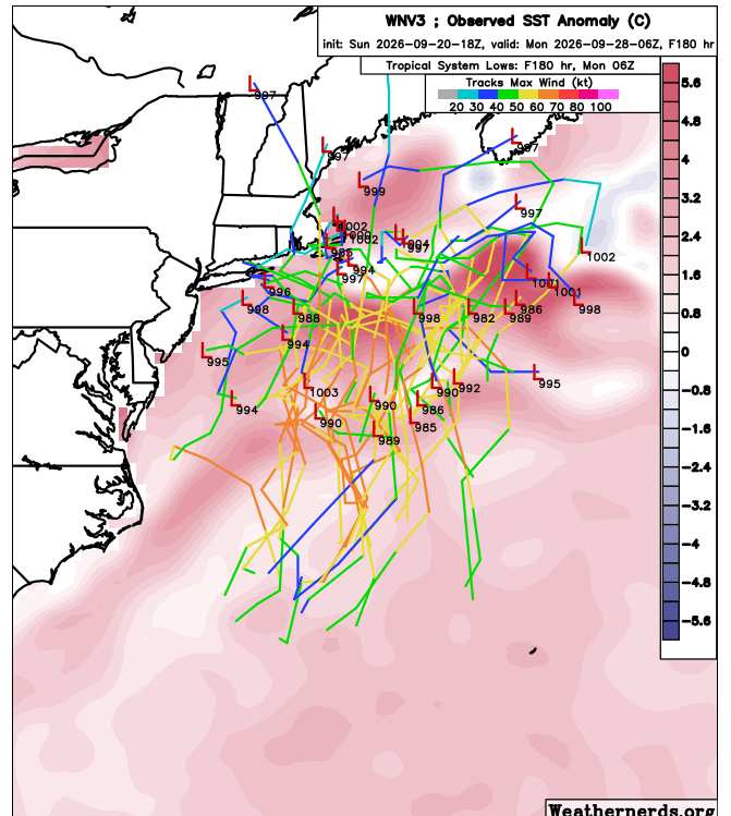
Today's 18Z DeepMind WNv3 Ensembles out to 180 Hr mostly keeping offshore


Post Extras: Print Post   Remind Me!   Notify Moderator  
cieldumortModerator
Moderator


Reged:
Posts: 2872
Loc: Austin, Tx
Re: Modeled Wet Hybrid Cyclone off Mid-Atlantic [Re: cieldumort]
      #116261 - Mon Sep 21 2026 11:06 PM

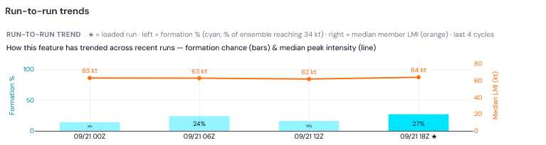
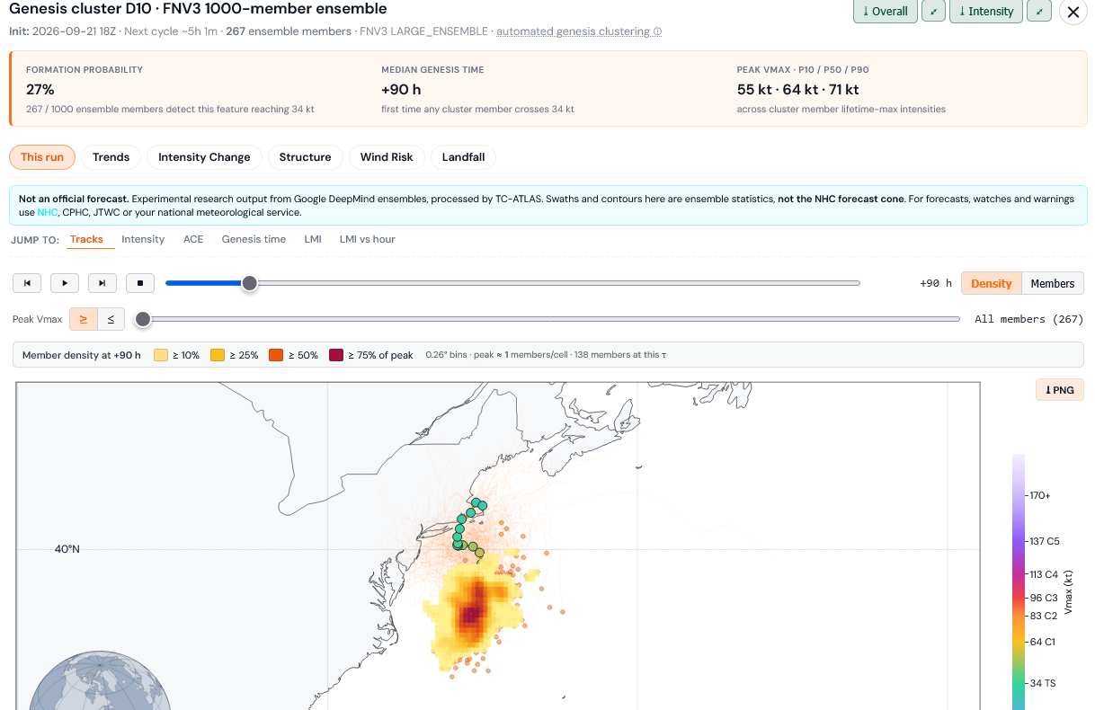
The DeepMind FNv3 ensembles, which attempt to forecast the formation of warm-cored, tropical cyclones (as opposed to classic Nor'easters), most recently has increased implied chances of tropical cyclone formation in or around the Gulf Stream with this system to 27%, with a mean genesis time of 90 hours out from 18Z today.


Credit: TC-ATLAS


Credit: TC-ATLAS


Post Extras: Print Post   Remind Me!   Notify Moderator  
Pages: 1


Extra information
0 registered and 0 anonymous users are browsing this forum.

Moderator:  CFHC, MikeC, Ed Dunham, Colleen A., Atricks, danielw, Clark, Christine H, RedingtonBeachGuy, SkeetoBite, Bloodstar, tpratch, typhoon_tip, cieldumort, Jackie M, Wigeon, Hank Buck 

Print Topic

Forum Permissions
      You cannot start new topics
      You cannot reply to topics
      HTML is disabled
      UBBCode is enabled

Rating:
Topic views: 332

Rate this topic

Jump to