MikeC
Admin
Reged:
Posts: 4622
Loc: Orlando, FL
|
|
4:50PM
Hurricane is now a Category 3 storm, more to come soon. Forecast track remains quite similar to the last one. Overall, the track has been numerically close to right on so far.
Hurricane Warnings are now posted for the lower Florida Keys, as tropical storm force winds may be approaching there tomorrow afternoon.
2:40PM
Pressure in has fallen to 956mb, possibly putting it over the edge for a Category 3 storm. We'll know in a bit.
2:00PM
Dennis is now 110MPH winds, very near Category 3 strength. And still about 65 miles away from Kingston in Jamaica. (To the Northeast)
Visitor and Nonresident evacuations have been ordered for the Florida Keys.
Meteorologists Clark Evans and Ed Dunham have discussions about , which you can find below this article or by clicking the Met blogs link on the left.
Original Update
The Florida Keys are now under a Hurricane Watch, including Florida Bay. South Florida from Golden Beach on the east coast, to Bonita Beach on the West coast are under a tropical storm watch.
 
It is still approaching Jamaica, and has a chance to strengthen some more. Interaction with Cuba should weaken it a bit before it gets in the Gulf, how much is up for debate, however.
An eye is now apparant on Visible Satellite Images

This was forced because of track uncertainties in the models. Check the Monroe County EM link below for Keys Evac information.
The track still takes it toward the Western Panhandle... More to come soon.
Event Related Links
Monroe County/Florida Keys Emergency Management Bulletins
StormCarib hurricane reports from observers in the Islands - Jamaican StormCarib Reports
Caribbean Island Weather Reports
Jamaican Meteorological Service
Guantanamo Bay, Cuba Radar
Florida Keys Long Range Radar Loop
Dennis
Animated Model Plot of
Model Plot Graphic from the South Florida Water Management District of
Dennis Spaghetti Model from boatus
Weather Underground Model Plots for
Quikskat Image of
Color Sat of
Floater Satellite (Visible) of with Storm Track Overlays
RAMSDIS high speed visible Floater of
Forecast Discussions for (Show All Locations):
Tampa. Mobile Bay,
New Orleans, Key West, Tallahassee.
Melbourne
|
hurricane_run
Storm Tracker

Reged:
Posts: 366
Loc: USA
|
|
looks like Jamaica is about to be hammered
|
Lysis
User

Reged:
Posts: 451
Loc: Hong Kong
|
|
Wow... he is opening up his eye:
This is incredible. I remember when he was just a blob of convection. It is like watching a child grow up. ...Who just happens to become a mass murderer
http://www.ssd.noaa.gov/PS/TROP/DATA/RT/float2-vis-loop.html
--------------------
cheers
Edited by Lysis (Thu Jul 07 2005 11:37 AM)
|
hurricane_run
Storm Tracker
Reged:
Posts: 366
Loc: USA
|
|
from the disscusion. full at the home page. FIXES FROM RECONNAISSANCE AIRCRAFT AND SATELLITE INDICATE THAT THE
MOTION HAS BEEN MORE NORTHWESTWARD THAN WEST-NORTHWESTWARD. THE
MID-TROPOSPHERIC RIDGE TO THE NORTH OF IS APPARENTLY WEAKER
THAN EARLIER PREDICTED. THIS MAY IN PART BE A RESULT OF ADDITIONAL
STEERING FLOW INFORMATION OBTAINED FROM THE NOAA G-IV JET
SURVEILLANCE MISSION LAST NIGHT. CONSEQUENTLY...SOME OF THE TRACK
GUIDANCE...IN PARTICULAR THE AND MODELS...HAVE SHIFTED TO
THE RIGHT OF THEIR EARLIER SOLUTIONS. THIS NECESSITATES AN
EASTWARD ADJUSTMENT OF THE OFFICIAL TRACK. ADDITIONALLY...THE
AIRCRAFT DATA SHOW THAT HAS STRENGTHENED AND THAT THE WIND
FIELD HAS EXPANDED...ESPECIALLY TO THE NORTHEAST. THE NEW TRACK
AND WIND FIELD FORECAST REQUIRES THE ISSUANCE OF WATCHES FOR
EXTREME SOUTHERN FLORIDA AT THIS TIME.
|
Jax Chris
Weather Watcher
Reged:
Posts: 28
Loc: Jacksonville Beach, FL
|
|
Quote:
looks like Jamaica is about to be hammered
Sure does; at least it looks like they're going to be on the south side of the eye, so that'll help them somewhat. Unless decides to drop down and pick up some rum, mon... Doesn't look like Cuba and the US Gulf Coast are going to be so lucky; somebody's going to be on the windward side for both of those.
Jax Chris
|
hurricane_run
Storm Tracker
Reged:
Posts: 366
Loc: USA
|
|
I know exactly what you mean.
|
bob895
Unregistered
|
|
Would expect a cat 3 hurricane at next advisory.
|
hurricane_run
Storm Tracker
Reged:
Posts: 366
Loc: USA
|
|
and that is not good.
|
FlaRebel
Weather Hobbyist
Reged:
Posts: 59
Loc: Tallahassee, FL
|
|
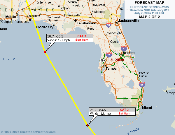
I assume on the second map the location for 121 MPH winds is 8 AM Saturday??
|
pcola
Storm Tracker

Reged:
Posts: 344
Loc: pensacola/gulf breeze
|
|
Accuweather is still sticking to its guns and saying Mississippi.
--------------------
Erin 95 , Opal 95, Ivan 04, Dennis 05, and that's enough!!!!
|
hurricane_run
Storm Tracker
Reged:
Posts: 366
Loc: USA
|
|
once it gets to 100kts (major status) it should be interesting to see how it acts.
( It really interested in CERC in hurricanes) and how they effect strength and direction.
( My thoughts and prayers go out to those in London.)
|
bob895
Unregistered
|
|
What is everyone predicting for rainfall amounts when reaches the U.S??
|
hurricane_run
Storm Tracker
Reged:
Posts: 366
Loc: USA
|
|
that eye is clearing up that is not a good sign. When is the next recon ETA at the storm?
|
Bloodstar
Moderator

Reged:
Posts: 465
Loc: Tucson, AZ
|
|
Quote:
once it gets to 100kts (major status) it should be interesting to see how it acts.
( It really interested in CERC in hurricanes) and how the effct strenght.
The way I visualize things, if the storm is large and major, it's going to tend to go straight. there will be wobbles, but it usually sticks to that path until something really starts to steer it. Once it hits Cuba... weakens a bit... I think that's when you'll see the potential for a turn. We shall see...
And to think, I'm heading to Atlanta in a few hours, and I'm supposed to drive back sunday day/evening.
Guess I'll be watching to see if I'm even going to be allowed back!

-Mark
--------------------
M. S. Earth and Atmospheric Sciences, Georgia Tech - May 2020
NOAA MADIS/HADS Programmer
U. Arizona PhD Student
|
SkeetoBite
Master of Maps

Reged:
Posts: 298
Loc: Lakeland, FL
|
|
Quote:
I assume on the second map the location for 121 MPH winds is 8 AM Saturday??
Oops! Good catch. Fixed.
|
Steve hirschb.
Unregistered
|
|
12Z further east through 36 hours....looks to be crossing Key West on this run.
|
XLM
Unregistered
|
|
I think the eye is just a little bit north of the original track...
|
hurricane_run
Storm Tracker
Reged:
Posts: 366
Loc: USA
|
|
there is always going to be wobbles and changes in course. the storm will not go along the predicted path. but is it goes over cubas mountains for awhile maybe it will weaken it somewhat before it can cause considerable damage.
|
Clark
Meteorologist
Reged:
Posts: 1710
Loc:
|
|
Full update coming on the met. blogs on the front page, but here are the highlights:
* ' northwesterly jog will spare the island of Jamaica from the worst, but they will still be dealing with hurricane-force winds for some time. Areas on the north side of the island will be especially prone to flooding due to the higher terrain & flow up the mountains towards the south.
* The eye is becoming better defined in satellite imagery; may be peaking near major hurricane intensity before land interactions begin to slow it down somewhat. Recon is on its way and a fix is due for the next hour or two.
* Models are trending further and further east with time, coming into line with the MM5 but still a bit west of the Canadian model. The upper-air pattern is becoming a bit better defined and the data input to the models from the surveillance plane has had a noticeable impact on the projected path of the storm.
More on track & intensity forecast and synoptic reasoning within the next half-hour.
--------------------
Current Tropical Model Output Plots
(or view them on the main page for any active Atlantic storms!)
|
Frank P
Veteran Storm Chaser
Reged:
Posts: 1299
|
|
I predict the rain to be horizontal.... 
|


 Threaded