MikeC
Admin
Reged:
Posts: 4625
Loc: Orlando, FL
|
|
8:30AM 8 July 2005
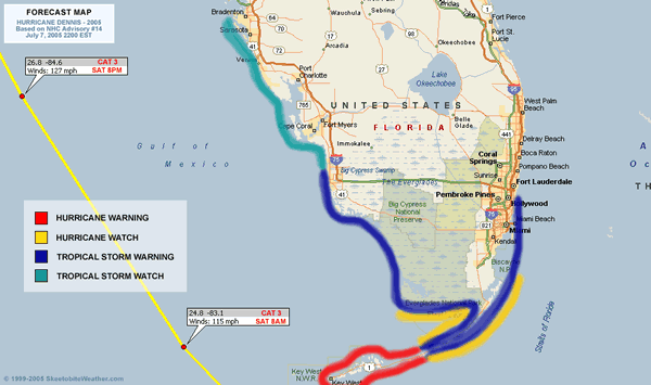
Data from the Hurricane Hunters indicate that has undergone yet another period of rapid intensification, now with a pressure drop of 12mb to 938mb and an increase in surface winds to at least 140mph. This comes from sampling the southeast quadrant; it remains to be seen whether or not stronger winds exist in the northeast quadrant. At the very least, a bump up in intensity will occur at 11am.
7AM 8 July 2005
Hurricane has remained a Category 4, even after being slightly disrupted by the Cuban peninsula earlier. it still has more of Cuba to go over to once again get disrupted, but in the meantime it is over very warm water now and has a chance to hold or strengthen its current strength until that happens.

This has a potential to devistate the areas over Cuba it crosses.

After Cuba, it will pass very close to Key West (maybe just west) -- close enough to feel hurricane strength winds. After which it will move northwest into the Eastern Gulf. Probably 150 miles or so west of the west coast of Florida, staying far enough offshore that the hurricane winds won't be felt along the west coast, although tropical storm force may be.
The short term 24-48 forecast track has been very good so far and the ultimate track is still trending some where along the Panhandle west toward New Orleans. With the highest probability near where Hurricane hit last year. The chances for a peninsular hit in Florida are dropping quickly. Which is good news for us in Florida. However,e it still has not cleared Cuba, so we must watch it. Probably until it passes north of our latitude. Still there is no reason to doubt the National Hurricane Center track. This would have landfall sometime late Sunday or Early Monday.
I know the folks in the Panhandle and Alabama do not want to hear this. And my heart goes out to them.
Please listen to local officials and or media as the storm nears. Follow any evacuation orders necessary. But do not evacuate unless you are asked to or live in a vulnerable area.
Original Update
Category 4 Hurricane is now approaching Cuba and will landfall, maybe twice, over the island. It's likely to be disrupted somewhat and weaken, although how much is up for debate.
 

The forecast track still points toward a western Florida Panhandle, but those west toward New Orleans and Eastward along the Western coast of florida will still need to watch . After crosses Cuba we should know more.

Clark Evans writes more in his blog below that you may be interested in.
More to come later...
Site Note News talkbacks are now in lockdown mode, which means that unregistered users cannot reply.
You can still post in the other forums besides talkbacks. This enables us to moderate a lot better. I hate doing this, but I can see obvious signs of "storm stress" on a few individuals. We'll make it open again as soon as it calms down.
Registration is open for anyone, you can register Using this link. Then you will be able to reply here.
Hopefully this will only last a short time.
Event Related Links
FloridaDisaster.org - Florida Emergency Management
Monroe County/Florida Keys Emergency Management Bulletins
StormCarib hurricane reports from observers in the Islands - Jamaican StormCarib Reports
Caribbean Island Weather Reports
Guantanamo Bay, Cuba Radar
Florida Keys Long Range Radar Loop
Tampa Bay, FL Long Range Radar
Miami, FL Long Range Radar
Dennis
Animated Model Plot of
Model Plot Graphic from the South Florida Water Management District of
Dennis Spaghetti Model from boatus
Weather Underground Model Plots for
Quikskat Image of
Color Sat of
Floater Satellite (Visible) of with Storm Track Overlays
Cienfuegosa, Cuba Radar - (Animated)
RAMSDIS high speed visible Floater of
Forecast Discussions for (Show All Locations):
Tampa. Mobile Bay,
New Orleans, Key West, Tallahassee.
Melbourne
Edited by Clark (Fri Jul 08 2005 08:33 AM)
|
Maggie'sMom
Registered User
Reged:
Posts: 4
|
|
Hello to all! I'm so grateful to this board and all its posters. I would go NUTS waiting on updates from other sources. What time do the next model runs come out? I'm trying to keep my eyes open (it's as if I watch and listen, I can somehow direct the other way.) Thanks for the info.
|
VandyBrad
Weather Hobbyist

Reged:
Posts: 80
Loc: Bryan, TX
|
|
Posted this in the other talkback just as this one was created so here goes again...
Quote:
-- but until the full suite of 00Z runs comes out, it'll be tough to tell.
Around what time do they become available publicly. I assume 00Z is midnight eastern time. How long after then until we can access them?
--------------------
Brad Shumbera
|
Clark
Meteorologist
Reged:
Posts: 1710
Loc:
|
|
I, too, got caught in the old thread with my reply, so here goes...
00z is midnight Greenwich Mean Time, or along the Prime Meridian to our east. Currently, it corresponds to 8p ET. Model guidance from that time is just starting to come out and should continue to do so through the rest of the night, depending upon each model and the computing power available to it.
--------------------
Current Tropical Model Output Plots
(or view them on the main page for any active Atlantic storms!)
|
Ron Basso
Storm Tracker

Reged:
Posts: 267
Loc: hernando beach, FL
|
|
Quote:
Posted this in the other talkback just as this one was created so here goes again...
Quote:
-- but until the full suite of 00Z runs comes out, it'll be tough to tell.
Around what time do they become available publicly. I assume 00Z is midnight eastern time. How long after then until we can access them?
The 00Z refers to Zulu Time (GMT) so subtract fours hours to get EDT. I have found it takes about 4-6 hours after the model start time to get the info
--------------------
RJB
|
gavsie
Verified CFHC User

Reged:
Posts: 18
Loc: Seminole Fl
|
|
When will we ba able to see the new data?
|
Clark
Meteorologist
Reged:
Posts: 1710
Loc:
|
|
Depends upon which site you use to get the data and how fast they get it. The is coming out right now and can be seen directly from the source at http://www.nco.ncep.noaa.gov/pmb/nwprod/analysis/namer/gfs/00/index_l.shtml other models will be available elsewhere and also at various times through the night.
Best advice: don't wait up on the 00Z model runs and just get some rest tonight. We'll all need it soon enough, I'm afraid.
EDIT: Speaking of the ...its landfall has shifted back slightly to the east once again, now paralleling the coast from Apalachicola to just west of Panama City in about two and a half days...or late morning-early afternoon Sunday. Not a big shock and only about 60-75 miles east of the track.
--------------------
Current Tropical Model Output Plots
(or view them on the main page for any active Atlantic storms!)
Edited by danielw (Fri Jul 08 2005 12:17 AM)
|
Ron Basso
Storm Tracker
Reged:
Posts: 267
Loc: hernando beach, FL
|
|
Quote:
When will we ba able to see the new data?
Sorry Clark, didn't mean to steal your thunder
I have found that the link below contains a nice suite of models which can be animated
http://moe.met.fsu.edu/tcgengifs/
--------------------
RJB
|
ohioaninmiss
Weather Watcher
Reged:
Posts: 32
Loc: Columbus, OH
|
|
Am I crazy or does the 00Z take right up the FL coast? I'm a bit new at reading these things! 
--------------------
Marie
Back in Ohio from a crazy summer in Mississippi!
|
VandyBrad
Weather Hobbyist
Reged:
Posts: 80
Loc: Bryan, TX
|
|
Thanks for the prompt reply Clark. I think I'm going to have to call it a night as I've got a long day of research in the lab ahead of me. I want to take a second to thank everyone in this community for all of the insite they provide into these storms. I've tried to follow FLHurricane.com pretty religiously lately to try and help me plan what sort of emergency steps I need to take to make my lab at UF ready for a storm. As of now, it looks like we'll be out of the most severe weather, nothing like we experienced with and Jeanne last year. As such, I don't think that I will take any steps tomorrow to "batten down the hatches" in the lab, but I'll have to keep a close eye on things in case decides to put a stop to the progress I've been making here. Such a scenario would put me in the lab on Sunday getting things ready. Unfortunately, the Gainesville area does not have a largely reliable weather source at our disposal. Most of our information comes out of Orlando or Jacksonville and neither of those mets pay much attention to us. That is where this community helps the most in my case. G'night all.
--------------------
Brad Shumbera
|
Breeezy
Registered User

Reged:
Posts: 8
Loc: Crystal River, FL
|
|
Clark....I love reading your posts. so may I ask what does the shift mean for the peninsular and how accurate is ?
|
cjzydeco
Weather Guru

Reged:
Posts: 120
Loc: Sebastian, FL
|
|
Quote:
The is coming out right now and can be seen directly from the source at http://www.nco.ncep.noaa.gov/pmb/nwprod/analysis/namer/gfs/00/index_l.shtml
I can't get this link to work.
Ah! Fixed it! Just drop the semi colon and it works great.
|
G. J.
Weather Watcher

Reged:
Posts: 30
Loc: Tampa, FL
|
|
cjzydeco,
that link is no good 
|
VandyBrad
Weather Hobbyist
Reged:
Posts: 80
Loc: Bryan, TX
|
|
To get Clark's link to work, remove the semicolon from the end of the URL.
http://www.nco.ncep.noaa.gov/pmb/nwprod/analysis/namer/gfs/00/index_l.shtml
--------------------
Brad Shumbera
Edited by VandyBrad (Fri Jul 08 2005 12:12 AM)
|
gavsie
Verified CFHC User
Reged:
Posts: 18
Loc: Seminole Fl
|
|
I haven't been able to get it to work either. I went on to NOAA site and tried to find it though. Has this cane gotten closer to the coast of florida?
|
danielw
Moderator

Reged:
Posts: 3526
Loc: Hattiesburg,MS (31.3N 89.3W)
|
|
Someone asked earlier about the next updates.
Updates are issued every 3 hours.
Main Advisories are 6 hours apart, with
Intermediate Advisories at 3 hours after the Main Advisories.
2 am Intermediate
5 am Main
8 am Intermediate
11 am Main
and so on.
Just remember 2-5-8-11. AM or PM (EDT) for the Advisory times.
|
HanKFranK
User

Reged:
Posts: 1841
Loc: Graniteville, SC
|
|
it went over that little jut at cabo cruz an hour or two ago... inner core looks less symmetrical now. it ought to take half of tomorrow crossing central cuba at an oblique angle. the progs are still for the panhandle in the end.... the intensity track looks fair though i take note of the fact that hurricanes approaching the northern gulf coast usually weaken more than forecast. i was thinking okaloosa county fl this morning.. a little east over to walton/bay as of the evening. not going over any further, though. 100kt looks about right, give or take 10kt. 4PM Sunday the 10th, + or - 3 hrs.
gonna go see if i can find when the last july category 4 hurricane was. i'm sure it'll take a while.
the wave near the islands is staying active and low. it has a good chance to be something when it reaches the islands in 4-5 days.
catch y'all folks later.
HF 0519z08july
|
ftlaudbob
Storm Chaser

Reged:
Posts: 829
Loc: Valladolid,Mx
|
|
Just got this on my weather bug.THIS STATEMENT RECOMMENDS ACTION TO BE TAKEN FOR RESIDENTS OF
COLLIER...MIAMI-DADE AND MAINLAND MONROE COUNTIES. HOWEVER...ANY
DEVIATION OF THE FORECAST TRACK TO THE RIGHT WILL INCREASE THE
THREAT FOR THE REMAINDER OF SOUTH FLORIDA POSSIBLY REQUIRING
ADDITIONAL WATCHES OR WARNINGS. ALL OTHER RESIDENTS OF SOUTH SHOULD
CONTINUE TO MONITOR THE PROGRESS OF HURRICANE SYSTEM ALSO. Clark,did you get my last post?
--------------------
Survived: 10 hurricanes in Rhode Island,Florida and the Yucatan of Mexico .
|
G. J.
Weather Watcher
Reged:
Posts: 30
Loc: Tampa, FL
|
|
I got it to work. Just copy it, paste it, then delete up unitl the last letter. I'm seeing these models skirt the west coast of FL 
|
abyrd
Weather Hobbyist
Reged:
Posts: 62
Loc: apopka
|
|
two thoughts on the model.
1. It looks like the initial location is too far south.
2. It has heading for the middle keys and then taking a sudden jog to the west, avoiding the keys and moving further off shore.
Is it late and I've had too many jack daniels tonight, or what would cause the sudden jolt west and then a continuation on the NW course. And, am I right on the too far south comment?
|


 Threaded