NONAME
Weather Guru

Reged:
Posts: 136
|
|
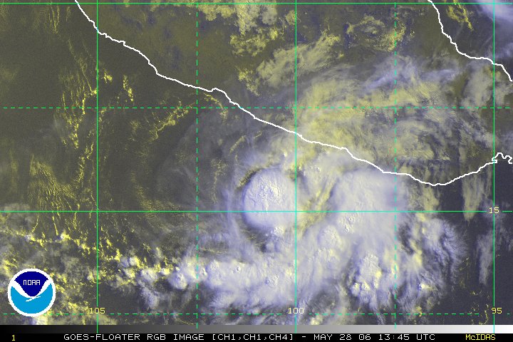
Aletta now has a good burst of convection over the center with cloud tops colder than80 degrees. This should lead to some strenthing.
Haven't posted in a while im glad to be back.
--------------------
I am a young Weather enthusiast and really want to get to college in a couple of years for meteorology.
|
Deep Surge
Unregistered
|
|
Indeed, A huge burst of deep convection has occurred during the past few hours. The main question is, will it make landfall? I think it will not and the thinks that too right now. It's going to get afwully close to making landfall though.
|
danielw
Moderator

Reged:
Posts: 3527
Loc: Hattiesburg,MS (31.3N 89.3W)
|
|
Current 0445Z imagery is showing a nice, consolidated . T numbers haven't updated since 29/2345Z. At that time Aletta was holding a 2.5 intensity.
0445Z RBG shows a moderate amount of lightning in the area. However, the WV image from the same time is showing a N to S elongated, double convective cluster, similar to a solid figure 8.
NW through SW convective band is disconnected from the main , and appears as an outflow boundary. Possibly the "death outflow" in the storms dying stage.
The few, weak bands that are connected are in the NE through SE Quadrant.
http://www.ssd.noaa.gov/PS/TROP/float1.html
TROPICAL WEATHER DISCUSSION
NWS TPC/NATIONAL HURRICANE CENTER MIAMI FL
0405 UTC MON MAY 29 2006edited~danielw
"...A RIDGE ALSO EXTENDS NE FROM THE ANTICYCLONE AT 12N106W ACROSS THE TROPICAL STORM CRESTING OVER THE GULF OF
MEXICO ALONG POINTS 27N97W 23N84W..."
http://www.nhc.noaa.gov/text/refresh/MIATWDEP+shtml/290317.shtml?
|
Margie
Senior Storm Chaser

Reged:
Posts: 1191
Loc: Twin Cities
|
|
Morning (no qualifier...I'm beyond sunburned).
Looks a little better this morning; it finally got out from under the jet and is not as sheared. It's in a nice little pocket. Looks like it'll become more organized today (convection is closer to the center) and tonight, and then into the shear and dry air, and that'll be it.
I'm really liking the longer sat loops -- I can sleep in and still see what you were looking at last night! :-)
* * * * * *
I learned something new with advisory #10A, not having watched the eastpac before -- apparently if there are no watches or warnings to be issued, then advisories are discontinued. That makes sense for the eastpac.
--------------------
Katrina's Surge: http://www.wunderground.com/hurricane/Katrinas_surge_contents.asp
Edited by Margie (Mon May 29 2006 03:19 PM)
|
Margie
Senior Storm Chaser

Reged:
Posts: 1191
Loc: Twin Cities
|
|
Danny was right...poof!...Aletta is so gone -- do you think I'll be able to remember what the "death outflow" looks like next time around? No convection even left now (image from around 0000Z attached), and the 11am PDT was the last advisory.
So what's up with this? :-) Oops:
TROPICAL WEATHER OUTLOOK
NWS TPC/NATIONAL HURRICANE CENTER MIAMI FL
400 PM PDT MON MAY 29 2006
FOR THE EASTERN NORTH PACIFIC...EAST OF 140 DEGREES WEST LONGITUDE..
THE NATIONAL HURRICANE CENTER IS ISSUING ADVISORIES ON TROPICAL STORM ALETTA...LOCATED ABOUT 130 MILES SOUTH-SOUTHWEST OF ZIHUATANEJO MEXICO.
ELSEWHERE...TROPICAL STORM FORMATION IS NOT EXPECTED THROUGH TUESDAY.
FORECASTER PASCH
--------------------
Katrina's Surge: http://www.wunderground.com/hurricane/Katrinas_surge_contents.asp
|
danielw
Moderator

Reged:
Posts: 3527
Loc: Hattiesburg,MS (31.3N 89.3W)
|
|
I learned the 'death outflow' from Jim Cantore. It works about 75% of the time or more.
The Death Outflow basically looks like the outflow you would see from any thunderstorm complex. A thin line of clouds/ light convection, detached from the parent cloud.
On the RGB satellite pic. It resembles a jellyfish or Portugese Man-O-War.
The word " poof" would be a good example to describe it. You'll know it when you see it.
|
Storm Cooper
User
Reged:
Posts: 1290
Loc: Panama City , FL
|
|
I think this may be one of the last model runs for her... check out the ... so confused
--------------------
Hurricane Season 2017 13/7/1
|
Margie
Senior Storm Chaser

Reged:
Posts: 1191
Loc: Twin Cities
|
|
Hey, I stand corrected. Well, that is, I noticed there was a 2pm PDT discussion (my web page had not refreshed the numbers earlier, I think, because I only saw discussion #10). So, maybe even though public advisories are no longer being issued, discussions and other parts of the "advisory" package still have to be issued...so, the is correct. I'll have to get the specifics on this, to satisfy my curiosity.
* * * * * *
Well maybe everyone knew this but me, since I am so new to this, and have not ever looked at the eastpac before. The forecast advisory pkg is issued for eastpac storms, but the public advisory statement part is not always issued, only when the storms are approaching land. It makes sense that the storms are usually moving the opposite direction, out to sea.
--------------------
Katrina's Surge: http://www.wunderground.com/hurricane/Katrinas_surge_contents.asp
Edited by Margie (Mon May 29 2006 09:31 PM)
|
danielw
Moderator

Reged:
Posts: 3527
Loc: Hattiesburg,MS (31.3N 89.3W)
|
|
Might check this out.
TROPICAL WEATHER DISCUSSION
NWS TPC/NATIONAL HURRICANE CENTER MIAMI FL
2205 UTC MON MAY 29 2006 (edited~danielw)
...SPECIAL FEATURE...
TROPICAL STORM ALETTA IS ESTIMATED NEAR 15.9N 102.1W AT 2100 UTC. THIS POSITION IS ABOUT 120 MILES...195 KM...SOUTH OF
ZIHUATANEJO MEXICO. ALETTA IS MOVING W AT 5 KT. ESTIMATED MINIMUM CENTRAL PRESSURE IS 1004 MB. MAXIMUM SUSTAINED WIND SPEED IS 35 KT WITH GUSTS TO 45 KT.
SCATTERED MODERATE TO STRONG CONVECTION WITHIN 150 NM ONLY OVER SE QUADRANT.
SHEAR IS EXPECTED TO BRIEFLY WEAKEN AND STRENGTHEN AGAIN IN ABOUT 36 HOURS SO THE ADVISORY MENTIONS A SLIGHT INCREASE FOR A DAY OR SO...WITHIN A WEAKENING TREND THEREAFTER.
SEE LATEST FORECAST/ADVISORY UNDER AWIPS/WMO HEADERS MIATCMEP1/WTPZ21 KNHC FOR MORE DETAILS.
http://www.srh.noaa.gov/data/NHC/TWDEP
|
Deep Surge
Unregistered
|
|
Aletta looks worse then most tropical waves right now. It just died in a matter of hours with the calling for some strengthening tonight. It went poof for sure and it's still a tropical storm!! I bet the will call it a depression at the next issue and it weakening to nothing.
What was the reason it went poof tonight? The shear was keeping the system from gaining strength 2 days ago and then the shear weakening and so did aletta? I'm confused of why Aletta was alive during the high shear and then it went poof when the shear disappeared.
|
danielw
Moderator

Reged:
Posts: 3527
Loc: Hattiesburg,MS (31.3N 89.3W)
|
|
As of late last night. The presence of 2 Lows, one NW and one NE of Aletta, might have had something to do with it.
Both of the Lows were lower in pressure than Aletta. One of the Mets can tackle this question better.
Aletta was within 150 miles of shore last night. The waters there are shallow. That should make them a bit cooler. With less Oceanic Heat Content.
|
Margie
Senior Storm Chaser

Reged:
Posts: 1191
Loc: Twin Cities
|
|
I learned more about the "death outflow." This stuff is so interesting.
It is surface outflow. So that means there is divergence at the surface, not convergence, like there should be, and so convection will collapse. And this part I am not so clear about but it is possibly caused by dry air being pulled in probably at the mid-level.
--------------------
Katrina's Surge: http://www.wunderground.com/hurricane/Katrinas_surge_contents.asp
|
Clark
Meteorologist
Reged:
Posts: 1710
Loc:
|
|
That's largely it -- tropical convection results from a nearly moist profile and has a natural resilience to downdrafts. But, bring in some dry air in the mid-levels and you create conditions favorable for strong evaporative cooling as well as the development of downdrafts. Downdrafts can help develop convection elsewhere, but more specifically they mark the collapse of the pre-existing convection. That's not good for a tropical cyclone.
--------------------
Current Tropical Model Output Plots
(or view them on the main page for any active Atlantic storms!)
|


 Threaded


