MikeC
Admin
Reged:
Posts: 4622
Loc: Orlando, FL
|
|
Hurricane Dean has made landfall in Mexico as a Category 5, the first Hurricane since Andrew that was a Category 5 hurricane at time of landfall. It is already weakening inland, but it should maintain hurricane intensity until it briefly reenters the Gulf in the Bay of Campeche. Warnings are up for much of Mexico around the Southern Edges of the Bay of Campeche.
It should continue westward and make a second landfall in Mexico and continue on into the mountains of Central Mexico, where it is expected to be torn up by the mountains.

92L is one of those disturbances that probably wouldn't be even talked about if it wasn't late August, it's still very disorganized this morning, but has a chance to develop, it continues westward around 20MPH. Things can change rapidly.
92L did not persist yesterday much at all, and there isn't much convection to speak of. Chances for development are very low.
Chances for Tropical Development of Wave Northeast of the Caribbean (92L) within the next 48 hours
Code:
(forget it) 0 1 2 3 4 5 6 7 8 9 10 (sure thing)

            [--*-----------------]
|
Random Chaos
Weather Analyst

Reged:
Posts: 1024
Loc: Maryland
|
|
Hmm, new thread started while I was posting. Moving my post here.
-----
Final report from landfall:
(I'm mostly just quoting stuff from the 5am discussion)
Wind:
* A PEAK FLIGHT-LEVEL WIND OF 165 KT WAS MEASURED JUST NORTH OF THE EYE.
* MAXIMUM SURFACE WINDS FROM THE SFMR WERE 124 KT...BUT IT IS HIGHLY LIKELY THAT THE MAXIMUM SURFACE WIND SPEED WAS NOT REPORTED BY THE SFMR INSTRUMENT.
* A GPS DROPSONDE IN THE NORTHERN EYEWALL MEASURED A WIND SPEED OF 178 KT AVERAGED OVER THE LOWEST 150 METERS OF THE SOUNDING.
BASED ON THE DROPSONDE AND THE FLIGHT-LEVEL WINDS...THE INTENSITY IS SET AT 145 KT.
If 178kt was measured, even with a 10% step down (and at 150 feet, 10% may be too large), that is 160kts (184mph), or 15kts faster than the surface value they used.
The 145kt value works out to 165mph.
Presure
A DROPSONDE IN THE EYE MEASURED A CENTRAL PRESSURE OF 906 MB JUST PRIOR TO LANDFALL.
SOME HISTORIC NOTES ARE IN ORDER HERE.
* THE 906 MB CENTRAL PRESSURE IS THE NINTH LOWEST ON RECORD FOR AN ATLANTIC BASIN HURRICANE...
* AND THE THIRD LOWEST AT LANDFALL BEHIND THE 1935 LABOR DAY HURRICANE IN THE FLORIDA KEYS AND HURRICANE GILBERT OF
1988 IN CANCUN MEXICO.
* DEAN IS ALSO THE FIRST CATEGORY FIVE HURRICANE TO MAKE LANDFALL IN THE ATLANTIC BASIN SINCE Andrew OF 1992.
Also, the last recon reported (08:14:00Z):
"CONTINUOUS LIGHTING AND SEVERE TURBULENCE SOUTH EYEWALL"
|
Lee-Delray
Weather Master

Reged:
Posts: 429
|
|
I saw this about 92L this AM. Also noticed that the models haven't been updated.
A BROAD AND DISORGANIZED AREA OF SHOWERS AND THUNDERSTORMS...LOCATED
A FEW HUNDRED MILES NORTH-NORTHEAST OF PUERTO RICO...IS ASSOCIATED
WITH A TROPICAL WAVE. DEVELOPMENT...IF ANY...OF THIS SYSTEM IS
EXPECTED TO BE SLOW TO OCCUR AS IT MOVES WESTWARD NEAR 20 MPH OVER
THE NEXT DAY OR .
|
pcola
Storm Tracker

Reged:
Posts: 344
Loc: pensacola/gulf breeze
|
|
The has done a good job initializing 92l...but this mornings run shows 92l crossing the fl peninsula as a small low, but intensifying in the gulf with very little movement..it will be interesting to see what some of the other model runs come up with
--------------------
Erin 95 , Opal 95, Ivan 04, Dennis 05, and that's enough!!!!
|
Raymond
Weather Guru
Reged:
Posts: 112
Loc: Germany
|
|
"178 KT AVERAGED OVER THE LOWEST 150 METERS OF THE SOUNDING."
Would be interesting to hear, what kind of things have to be taken into account, if you want to make an estimation of the surface wind with the help of this data!
145 kt by the seems to be very conservative!?
|
Psyber
Storm Tracker

Reged:
Posts: 234
Loc: Ontario, Canada
|
|
Quote:
"178 KT AVERAGED OVER THE LOWEST 150 METERS OF THE SOUNDING."
Would be interesting to hear, what kind of things have to be taken into account, if you want to make an estimation of the surface wind with the help of this data!
145 kt by the seems to be very conservative!?
They'll do a post hurricane analysis of the real data and put a definate speed/barometer reading on Dean before they retire him. Unfortunately for Mexico, theres really not a whole lot of difference between 160, 165 and 170mph, all three are going to scour the land of anything not bolted into concrete. There was also the potential for up to an 18 foot storm surge,(there are reports of many piers and docks which are gone). So far the deathtoll is at 7(before landfall in Mexico so it's sure to go up because no matter how many 's happen, people just refuse to get out of the way of these things)
To be honest, if Dean hadn't run out of ocean, we'd be probably looking at a sub 900/180mph+ hurricane today.
--------------------
The safest way to deal with a potential Hurricane hitting you...is to leave and just not be there at all.
|
Jorge Nakazawa
Registered User
Reged:
Posts: 9
Loc: Mexico City, Mexico
|
|
Latest info at 8:00 Central Time by the Mexican Meteorological Service reports a central pressure of 935 and winds of 127 mph. That will make Dean a Cat 3. Given the weakening rate from landfall and its location halfway through the Yucatan peninsula I expect it will weaken to a Cat 2 by the time it gets back to sea in the Campeche Bay. Unfortunately, the report does not indicate which stations are the source of data. Here is the link (in spanish though) http://smn.cna.gob.mx/
Jorge G. Nakazawa
|
weatherguy08
Weather Hobbyist
Reged:
Posts: 60
Loc: Miami, Fla.
|
|
11:30 AM out, sounds like the is writing the system off. "UPPER-LEVEL WINDS ARE BECOMING LESS
FAVORABLE FOR DEVELOPMENT AS THIS SYSTEM MOVES WESTWARD NEAR 20
MPH."
I do not agree with the statement about unfavorable winds though because if you look at the attachment, this graphic from CIMSS shows wind shear being quite low and no Saharan Air Layer in place.
|
GuppieGrouper
Weather Master
Reged:
Posts: 596
Loc: Polk County, Florida
|
|
Does anyone know when the Endeavour will actually be landing within the estimated time? I can not find a news source that seems to be saying, and thought it would be interesting to watch the operation with the weather system in mind.
--------------------
God commands. Laymen guess. Scientists record.
|
B.C.Francis
Storm Tracker
Reged:
Posts: 331
Loc: Indiatlantic Florida
|
|
I think in about twenty mintues from now it should be coming in from the south. We here in Indiatantic should hear the sonic boom shortly if thats the case.....Weatherchef
|
Hootowl
Weather Hobbyist
Reged:
Posts: 77
Loc: New Port Richey, Fl
|
|
Shuttle lands in approx 22 mins. You can watch it here. http://www.nasa.gov/mission_pages/shuttle/main/index.html
Looks like we might have a calm spell for a little bit since 92L doesn't seem like a go.
Cross your fingers!
|
weather999
Weather Watcher
Reged:
Posts: 25
Loc: southwestern ontario, canada
|
|
Quote:
Latest info at 8:00 Central Time by the Mexican Meteorological Service reports a central pressure of 935 and winds of 127 mph.
Is this a measurement from the ground, and in that case, were there any measurements near Chetumal prior/during/after landfall?
Also, does anyone think there is a chance that Dean could maintain a circulation over the central mountains of Mexico and emerge in the E. Pacific? I guess it partly depends how strong the storm will get at the second landfall.
|
syfr
Verified CFHC User

Reged:
Posts: 19
Loc: Central NC
|
|
Given the height of the mountains and the width of the land mass, I would think that quite improbable. Dean will lose much of it's strength going over the relatively narrow Yucatan peninsula, which as I recall (I've visited the Mayan ruins in Tulum, near landfall) is quite flat and featureless. I'm sure it will rapidly fall apart over land on the mainland in Veracruz. That having been said, there's probably a lot more people in the area of the second landfall.. than the area just north of Belize and south of Tulum.
|
Clark
Meteorologist
Reged:
Posts: 1710
Loc:
|
|
Quote:
"178 KT AVERAGED OVER THE LOWEST 150 METERS OF THE SOUNDING."
Would be interesting to hear, what kind of things have to be taken into account, if you want to make an estimation of the surface wind with the help of this data!
145 kt by the seems to be very conservative!?
It's the lowest 50-100 meters that have the strongest negative impact on the wind speeds experienced, largely due to frictional processes. Take a look at this graphic from the 's webpage illustrating the "normalized wind speed" taken from a composite of many dropsondes into hurricane eyewalls:
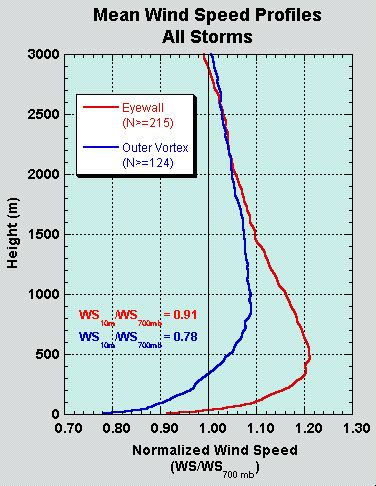
We're looking at a 20-25% decrease from 150m to the surface, particularly using the eyewall profile. It's 700mb that the 10% rule mentioned before applies to the most.
--------------------
Current Tropical Model Output Plots
(or view them on the main page for any active Atlantic storms!)
|
Clark
Meteorologist
Reged:
Posts: 1710
Loc:
|
|
Quote:
11:30 AM out, sounds like the is writing the system off. "UPPER-LEVEL WINDS ARE BECOMING LESS
FAVORABLE FOR DEVELOPMENT AS THIS SYSTEM MOVES WESTWARD NEAR 20
MPH."
I do not agree with the statement about unfavorable winds though because if you look at the attachment, this graphic from CIMSS shows wind shear being quite low and no Saharan Air Layer in place.
As I mentioned in a post on 92L in yesterday's thread, it is caught in a shearing environment to the NE of an upper low centered north of Hispaniola. The outflow from Dean helped accelerate the jet stream to the south of this upper low that largely helped to intensify the upper low. Furthermore, the winds are converging at upper levels over the disturbance due to the counterclockwise flow around the upper low and the clockwise flow around a subtropical ridge to its north. As a result, the odds on 92L are not that high for development.
--------------------
Current Tropical Model Output Plots
(or view them on the main page for any active Atlantic storms!)
|
Raymond
Weather Guru
Reged:
Posts: 112
Loc: Germany
|
|
Thank you, Clark!
But it says, that´s avaraged over the lowest 150 m and so it´isn´t at 150 m. So I would say you have to reduce around the half of he 20-25%, i.e. roughly 12%. That would give something like 156 kt.
Ok, whatever it had been, it had been horribly high!
|
Random Chaos
Weather Analyst
Reged:
Posts: 1024
Loc: Maryland
|
|
I just did some research and found a government research publication that states that the 150m eyewall dropsonde to surface adjustment is 85%.
That being the case, 178kt winds becomes 160kt / 184mph surface winds.
This is assuming of course that the 178kt measurement wasn't in an embedded tornado.
|
Thunderbird12
Meteorologist
Reged:
Posts: 644
Loc: Oklahoma
|
|
The dropsonde data suggested somewhat higher winds, while the onboard SFMR suggested lower winds (I don't think it showed anything above 123 kts). With that conflicting information, it seems like they just went with the standard 10% reduction from 700 mb for the final wind estimate.
The dropsonde data is not necessarily representative. As Random Chaos alluded to above, the dropsonde may report very high winds if it gets caught in some sort of meso-vortex which are not representative of the system as a whole. In one of the monster hurricanes of the last few years (I can't remember which off of the top of my head), I remember seeing a dropsonde wind observation of over 200 kts. The other dropsondes into the northern eyewall of Dean late last night (looks like there were 5 total) did not show anything higher than 136 kts in the lowest 150m.
Determining the maximum sustained winds of a hurricane is a very tricky business and probably something that is not done very accurately, even in this advanced age.
|
Clark
Meteorologist
Reged:
Posts: 1710
Loc:
|
|
Quote:
Thank you, Clark!
But it says, that´s avaraged over the lowest 150 m and so it´isn´t at 150 m. So I would say you have to reduce around the half of he 20-25%, i.e. roughly 12%. That would give something like 156 kt.
Ok, whatever it had been, it had been horribly high!
Yeah, it was averaged in the lowest 150 meters, though I would still tend to think that there were a fair number of data points closer to 150 m skewing things than not. The points made below your post and above this one hit it on the head, however.
As for the storm Thunderbird is getting at -- I believe it's Isabel from 2003.
--------------------
Current Tropical Model Output Plots
(or view them on the main page for any active Atlantic storms!)
|
HanKFranK
User

Reged:
Posts: 1841
Loc: Graniteville, SC
|
|
dean will end up with around 20 hours over water for it's stretch over the bay of campeche. the inner core looks about as bad as that of of 2005 after it's crossing of cuba... i'd expect the cat 1 rating is on and that it can probably come back up to a 3 before it goes in again, if the recovery starts tonight. some of the modeling is showing the upper system getting over to the pacific and spawning a weak surface system that meanders into the gulf of california.. not terribly likely, but occasionally one of these systems will get over and kick off a pacific system (iris 2001, gert 1993). these systems don't tend to do well.
92L isn't improving any. some of the basic features that will allow it to persist and provide a minor menace to the east coast of florida are unchanged, but it really doesn't have much going for it. the upper low to the south is rending whatever convergence is going on at the southern end, and it doesn't have a great deal of convection to work with. none of the modeling likes it either (gfs has gotten suspiciously quiet, and none of the others seem to like it anymore). considering the time of year i wouldn't be surprised if 92L keeps plodding on until it finds a niche, or if something else starts brewing. tis the season.
ridging persists in the eastern united states and that general pattern keeps trying to hold in most of the medium to long range modeling. when trouble comes, the pattern we've been seeing in august will tend to push it towards land... unless the weak trough in the central atlantic becomes more robust.
HF 2217z21august
|


 Threaded


