MikeC
Admin
Reged:
Posts: 4552
Loc: Orlando, FL
|
|
8:00PM EDT Update 18 July 2008
According to the National Hurricane Center's Tropical Weather Outlook released at 8PM EDT, The low off the Georgia coastline is forming into Tropical Depression #3 and at 11:00 PM EDT the confirmed that it has become Tropical Depression # 3.
5:30PM EDT Update 18 July 2008
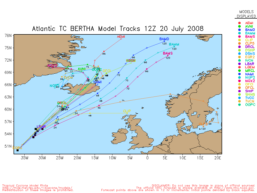
Bertha is once again a Hurricane, still moving quite far away from land, interestingly enough Iceland may have to deal with Bertha at some point.
The recon once again went through the wave in the Central Caribbean (94L), and did not find a closed circulation. This shows off now and then, but doesn't actually develop. The outflow on it is good, the circulation is not. Thus it is worth watching over the next several days.
The low off the Georgia coast, (96L) has a good presentation on radar, but probably will not be upgraded until recon goes out there tomorrow if at all.
Right now it has more against it being upgraded than for it. T-numbers are too low, circulation isn't quite well formed enough (but better than the Caribbean wave). Dry air is hampering it on the Northwestern Side, and the Satellite estimates (T- Numbers) don't support it yet either. It the latest convective burst sticks it may be upgraded later tonight or tomorrow morning.
Due to the close proximity of land the South East, in Particular South and North Carolina, Georgia, and perhaps Southeast Virginia should be watching this system closely
1:30PM EDT Update 18 July 2008
Recon Aircraft is on its way to the wave in the Caribbean (94L).
A Special Disturbance statement was issued this morning for both 94L and 96L, Recon is scheduled to investigate both, and one or both of the systems may form into a depression today or tomorrow.
Chances (as of 1:30PM) for 94L: 45%, 96L: 55%
Those in the Central and Western Caribbean, Yucatan, and Western Cuba will want to keep a close eye on 94L, and those in Georgia, and both of the Carolinas (and maybe southeast Virginia) will want to watch 96L.

What do you think it will do? Forecast Lounge is open for The Caribbean Wave 94L here and the Low off Georgia 96L Here
Registered users may want to click here to set their location -- by setting your location (lat/long) you will soon be able to get tailored current hurricane info and statistics relative to your marked position that you can see on our Google Map Storm Plots.
11:45 AM EDT Update 18 July 2008
Special Disturbance statement issued for both 94L and 96L, Recon is scheduled to investigate both, and one or both of the systems may form into a depression today or tomorrow.
Chances (as of 1:30PM) for 94L: 45%, 96L: 55%
Those in the Central and Western Caribbean, Yucatan, and Western Cuba will want to keep a close eye on 94L, and those in Georgia, and both of the Carolinas (and maybe southeast Virginia) will want to watch 96L.
What do you think it will do? Forecast Lounge is open for The Caribbean Wave 94L here and the Low off Georgia 96L Here
Registered users may want to click here to set their location -- by setting your location (lat/long) you will soon be able to get tailored current hurricane info and statistics relative to your marked position that you can see on our Google Map Storm Plots.
6:30 AM EDT Update 18 July 2008
This morning remains status Quo. The wave in the Western Caribbean (95L) has moved over Nicaragua and is causing rain there, and has also kept it from developing further.

The wave in the central/Eastern Caribbean (94L) is still disorganized, but will be worth watching later as it moves away from Venezuela and the Netherlands Antilles/Aruba. Most of the convection in the system is to the north of it. The system is persisting, the convection is not, and not until both do will it have a better chance to develop. Still the model projections will have us watching it into next week. (45% chance of development today)
The low off the coast of Georgia (96L) has not moved much during the night, it has basically drifted slowly to the north if anything. This morning its entraining a lot of dry air from the northwest which should keep this system weak, if it persists through the dry air it may form later, but chances are it will remain weak. It is being monitored because it is close to land. 25% chance of development today.
Tropical Storm Bertha is moving Northeast away from all land areas now at a rapid pace.
Original Update
Tonight there are a few storms in the Atlantic that could develop, but none of the systems are likely to. If it were August or September, it's very likely the entire tone of this article would be different.
Tropical Bertha is still moving out to sea and may become within 4 days or so.
The waves in the Caribbean, neither of which are likely to develop. 95L in the West and 94L in the East.

The western wave (95L) is too close to land to develop, but should give Central America a good deal of Rainfall.
The eastern wave (94L) has some Recon Aircraft going through it, but conditions and the system itself aren't all that favorable, but still has a small chance to develop. Again if it persistently shows convection (which to this point it hasn't) then it would become worth watching, right now it is not.
The last recon plane through there still did not find anything worth upgrading to a depression.

The low off the coast of Georgia (96L) was the low in the Gulf prior to moving across Florida yesterday, it's now over the Gulf Stream and has the potential to become a depression.
The Georgia Low's current movement is slowly northward (or even northwestward) which means it may develop before nearing land in the Carolinas. Because of the close proximity to land, its somewhat less likely to develop.
The position its in, and the conditions around it are in doubt enough that people in these areas need to watch it, especially if it does form, in case rapid development occurs.
Despite this, There is only about a 33% chance of development. At the very least it would be a rain maker for parts of the Carolinas if comes onshore. And that's likely all that it will be. Be glad it is July and not late August.
Long Term Radar Recording of 96L HCWX Level 3 Radar Recording
East Caribbean (94L) Wave Chances of Development in the next 24 hours
Code:
(forget it) 0 1 2 3 4 5 6 7 8 9 10 (sure thing)

            [--*------------------]
West Caribbean (95L) Wave Chances of Development in the next 24 hours
Code:
(forget it) 0 1 2 3 4 5 6 7 8 9 10 (sure thing)

            [-*-------------------]
Low Off Georgia Coast (96L) Chances of Development in the next 24 hours
Code:
(forget it) 0 1 2 3 4 5 6 7 8 9 10 (sure thing)

            [------*--------------]
Event Related Links
Southeast Radar Composite (loop)
Netherland Antilles/Aruba Radar 1
Netherland Antilles/Aruba Radar 2
|
weathernet
Storm Tracker
Reged:
Posts: 296
Loc: Elsewhere
|
|
If this were August, Sept. , or October, I'd be a little more bullish on faster development with this low off the N. Florida coast. If steering was weaker and it could buy more time, i'd think it might be the most likely prospect for development. As for 94L, seems arc clouds shooting out to its west and northwest, and I see nothing of a circulation. That said, and including newly designated 96L, I still think that the best near term chance for any development, may come from what will be some ugly conglomeration of what remains in the W. Caribbean in the next couple of days.
Lots of sputtering systems, but no development; and yet we need to remind ourselves that this is "July". Am simply impressed at the appearant ease of so many systems even trying to spin up. Where convective consistantcy and organization has been an issue, we are seeing some pretty impressive waves, most of which are having little trouble at least trying to develop some low to mid level rotation.
|
cieldumort
Moderator

Reged:
Posts: 2315
Loc: Austin, Tx
|
|
96L potentially poses the soonest threat to the . Conditions for further development aren't at all half bad, and it looks like a closed low at the surface is already taking shape. Steering currents may be a little weak right now, allowing it even more time to percolate and come together while over the warm Gulf Stream, but eventually a turn back to the NNE or N or NNW looks entirely plausible.. possibly putting the Carolinas in play for a landfalling named system.
In the very near-term, looks like 95L might still be trying to pull an 11th hour upset.
Currently, there appears to be two LLCs, within the much broader low pressure area. One of these, situated near 14.2N 83W, may becoming dominant. The other, which has been the source of tracking for purposes of assigning T numbers and everything else, located nearer to 13.5N 82.5W, does have a nice blow up of convection right on top, but this LLCC is also not within the approximate center of the broad circulation center... and area buoy and ship reports suggest that the dominant center could be the one a little more north.
And here's a recent buoy report worth noting:
Station 42057 - Western Caribbean
Supplemental Measurements Highest 1 minute Wind Speed
Time (GMT) WSPD WDIR
2109 30.9 kts ENE ( 58 deg true )
Longer-range, Invest 94L has every reason to have those of us in the western GOM watching closely. It has managed to stay just weak enough all along to keep south of an early turn to the NW and/or recurvature. Once it is west of the Graveyard and into the central Caribbean, there's every reason to believe that it could snap together on a dime, and track WNW to NW.
|
Ed in Va
Weather Master
Reged:
Posts: 489
Loc:
|
|
I'm not sure about development, but it looks to me like it's going to move NE away from the coast. The clouds at already moving that way: http://www.goes.noaa.gov/HURRLOOPS/huecwv.html
--------------------
Survived Carol and Edna '54 in Maine. Guess this kind of dates me!
|
MikeC
Admin
Reged:
Posts: 4552
Loc: Orlando, FL
|
|
Quote:
I'm not sure about development, but it looks to me like it's going to move NE away from the coast. The clouds at already moving that way: http://www.goes.noaa.gov/HURRLOOPS/huecwv.html
I've been watching the radar, and I'm not seeing that there, but I do notice what you mention on the satellite. The dry air north of it may play a factor too. Need a bit more model input first to be 80% sure.
i'm turning on a long term recording of 96L to watch this a bit closer, you can see that at Long Term Radar Recording of 96L.
The East Caribbean wave (94L) isn't out, it's just not doing anything in the near term.
Additionally:
HCWX Level 3 Radar Recording
|
scottsvb
Weather Master
Reged:
Posts: 1184
Loc: fl
|
|
It should get alittle tighter tomorrow and I feel it should have a good chance at being classified when recon goes out there unless it falls apart later tonight. Anyways it will move more NW when it gets better established with the midlevel flow. A weaker system will move WNW towards Belieze. Anything after 72hrs is up in the air,..as is right now since its not classified yet.
scottsvb
(post linked to a previously moved entry.)
Edited by Ed Dunham (Fri Jul 18 2008 04:33 AM)
|
Wingman51
Weather Guru

Reged:
Posts: 126
Loc: Orlando, FL
|
|
Here is part of the discussion from Charleston SC this morning - - are they seeing a new center definition>
NEAR TERM /UNTIL 6 PM THIS EVENING/...
-- Changed Discussion --THERE HAVE BEEN SOME VERY INTERESTING DEVELOPMENTS SINCE 08Z IN
REGARDS TO THE TROPICAL LOW PRES OFF THE GEORGIA COAST. IT APPEARS
A NEW SURFACE LOW MAY BE FORMING NEAR THE WEST WALL OF THE GULF
STREAM ON THE LEFT SIDE OF THE EXPANDING SHIELD OF COLD CLOUD
TOPS TO THE E OF THE SABSOON NETWORK OFF THE SE GEORGIA COAST.
THE INITIAL EDDY JUST TO THE E OF BRUNSWICK SEEMS TO BE PLAYING
OUT AND THIS NEW LOW MAY BECOME A TROPICAL DEPRESSION TODAY OR
EVENTUALLY A FULL FLEDGED TROPICAL SYSTEM BY THIS WEEKEND GIVEN
IT/S POTENTIAL NEW FOUND LOCATION. 06Z MODELS SEEM TO BE KEEN ON
THIS IDEA AS WELL WITH A 24 HOUR LOW PRES POSITION 40 TO 50 NM SE
OF CHARLESTON.
|
zacros
Weather Hobbyist

Reged:
Posts: 57
Loc: Johns Island, SC
|
|
You can see the new low developing ENE of JAX out over the Gulf Stream on radar. The new low appears to be ESE of the low that is visible from the satellite loops.
weather.com loop
|
LoisCane
Veteran Storm Chaser

Reged:
Posts: 1236
Loc: South Florida
|
|
the joy of that weather.com site is that is you can go to International and switch to clouds and watch 94 as well.
Seems a transitional day for both Invests we are watching here.
Many similarities.
--------------------
http://hurricaneharbor.blogspot.com/
|
WeatherNut
Weather Master
Reged:
Posts: 412
Loc: Atlanta, GA
|
|
I've been looking at the animated visible loop off the GA coast
http://weather.cod.edu/analysis/loops/satmaster.pl?Georgia
and it looks like the LLC just scooted itself due east under the heaviest convection. It almost looks like it was "sucked in". I think if it gets lined up vertically and some distance from the coast, this could pop
--------------------
Born into Cleo (64)...been stuck on em ever since
|
zacros
Weather Hobbyist
Reged:
Posts: 57
Loc: Johns Island, SC
|
|
The convection for this low appears to be deepening and trying to wrap around the low. The overall cloud cover is also growing. I checked the buoys, but they are not showing any corresponding increase in wind speed. It will be interesting to watch over the next day or so. Regardless, it looks like my sons birthday party at the beach is out of the picture.
Rainbow Loop
|
Beaumont, TX
Storm Tracker
Reged:
Posts: 318
|
|
New tropical disturbance statement issued. Looks like both 94L and 96L are trying to form. Planes are supposed to investigate.
Getting interesting for sure.
|
cieldumort
Moderator
Reged:
Posts: 2315
Loc: Austin, Tx
|
|
There can be little doubt that 96L (off the coast of Georgia) is now blowing up deep convection right on top of its LLCC. This development, given a little more of it for a little longer, should begin to drop surface pressures in the center and increase the wind speed throughout the system. A tropical depression could now form at any time today.
Track is fairly plain vanilla. Steering currents are light, but high pressure should gradually build into and along the east coast this weekend. This should allow 96L to travel generally north - along, just within, or just outside of the coasts of GA, SC and/or NC for the next few days, before probably hooking out to sea by early next week. 96L could be a slow scraper.
94L - This one has us here in Texas starting to pay a little more attention, and with very good reason. Simply put, hunters are flying back in today to determine if a tropical depression - or tropical storm - has already formed. Not much in the immediate area in the way of ship and buoy reports to compare satellite presentation with for some ground-truthing quality control, but based on satellite presentation alone, there's an awful lot of "there," there, now.
|
Rich B
British Meteorologist
Reged:
Posts: 498
Loc: Gloucestershire, England, UK
|
|
Well RECON are now entering the Caribbean disturbance with the latest HDOB showing them dropping altitude as they penetrate the system. Will be interesting to see what they find. Satellite imagery indicates that the whole system is consolidating further north than it had been tracking, and now poses more of a threat to the northwestern Caribbean. As for 96L, that one too has developed markedly this morning. I think that the system could very well get classified without recon as its proximity to land means it can be more easily monitored with radar and the like. This disturbance is somewhat lopsided, with the convection on the east of the circulation - due in part to land interaction and dry air entrainment on the west.
--------------------
Rich B
SkyWarn UK
|
weatherguy08
Weather Hobbyist
Reged:
Posts: 60
Loc: Miami, Fla.
|
|
I'm tracking the RECON mission through Google Earth. So far, nothing stands out, though there have been flight level winds in the 30-35 knot range.
Google Earth Data: http://www.tropicalatlantic.com/recon/ge/Atlantic.kmz
|
cchsweatherman
Weather Watcher
Reged:
Posts: 34
|
|
Bare in mind that they've been flying at about 400 feet above the surface. So, the recon is showing 30 to 35 kt. winds at the surface. If they find a closed circulation, you have Tropical Storm Cristobal.
|
danielw
Moderator

Reged:
Posts: 3525
Loc: Hattiesburg,MS (31.3N 89.3W)
|
|
SPECIAL TROPICAL DISTURBANCE STATEMENT
NWS TPC/NATIONAL HURRICANE CENTER MIAMI FL
1125 AM EDT FRI JUL 18 2008
THIS STATEMENT CONCERNS TROPICAL WEATHER SYSTEMS.
SATELLITE IMAGES INDICATE THAT THE AREA OF LOW PRESSURE LOCATED IN
THE CENTRAL CARIBBEAN SEA ABOUT 400 MILES SOUTHEAST OF JAMAICA
CONTINUES TO BECOME BETTER-ORGANIZED. AN AIR FORCE RESERVE UNIT
RECONNAISSANCE AIRCRAFT IS SCHEDULED TO INVESTIGATE THIS SYSTEM
THIS AFTERNOON TO DETERMINE IF A TROPICAL DEPRESSION OR TROPICAL
STORM HAS FORMED. ALL INTERESTS IN THE CENTRAL AND WESTERN
CARIBBEAN SEA SHOULD CONTINUE TO MONITOR THE PROGRESS OF THIS
SYSTEM AS IT MOVES WESTWARD AT 15-20 MPH. FOR INFORMATION SPECIFIC
TO YOUR AREA...PLEASE CONSULT STATEMENTS FROM YOUR LOCAL WEATHER
OFFICE.
SURFACE OBSERVATIONS AND SATELLITE IMAGES INDICATE THAT
A LOW PRESSURE SYSTEM LOCATED JUST OFF THE COASTS OF GEORGIA AND
SOUTH CAROLINA IS ALSO BECOMING BETTER ORGANIZED. ENVIRONMENTAL
CONDITIONS ARE CONDUCIVE FOR FURTHER DEVELOPMENT...AND A TROPICAL
DEPRESSION COULD FORM TODAY OR TOMORROW. AN AIR FORCE RESERVE
HURRICANE HUNTER AIRCRAFT IS SCHEDULED TO INVESTIGATE THIS SYSTEM
TOMORROW...IF NECESSARY. ALL INTERESTS ALONG THE COASTS OF
GEORGIA...SOUTH CAROLINA...AND NORTH CAROLINA SHOULD MONITOR THE
PROGRESS OF THIS SYSTEM. LOCALLY HEAVY RAINFALL IS POSSIBLE IN
THESE AREAS DURING THE NEXT COUPLE OF DAYS AS THIS SYSTEM MOVES
SLOWLY NORTHEASTWARD NEAR THE COAST. FOR INFORMATION SPECIFIC TO
YOUR AREA...PLEASE CONSULT STATEMENTS FROM YOUR LOCAL NATIONAL
WEATHER SERVICE FORECAST OFFICE.
|
craigm
Storm Tracker

Reged:
Posts: 327
Loc: Palm City, Florida
|
|
Is this July 18 or Sept 18. Anyway 94L is looking more impressive. Models look to be initialized too far south. The center appears to be somewhere between 14N -15N and 71W - 72W judging from IR and last microwave pass. Also low shear environment will allow the storm to stack more vertically consequently I'm thinking some of the coldest tops are near the center, but I've been wrong before.
--------------------
Why I'm here:
Weather hobbyist
Edited by craigm (Fri Jul 18 2008 06:53 PM)
|
craigm
Storm Tracker
Reged:
Posts: 327
Loc: Palm City, Florida
|
|
Forecast shear will be decreasing to non existent in front of 94L in the next 5 days.
http://www.meteo.psu.edu/~gadomski/COMPSHEARATL_12z/comploop.html
96L is ramping up also. Wondering if they will both be upgraded at the same time. That would be a 1st.
--------------------
Why I'm here:
Weather hobbyist
|
Robert
Weather Analyst

Reged:
Posts: 364
Loc: Southeast, FL
|
|
I wonder how strong 96l can get? I mean its got good circualtion going and real warm water temps what are the shear value supposed to be like in 36h
|


 Threaded


