Random Chaos
Weather Analyst

Reged:
Posts: 1024
Loc: Maryland
|
|
Following off of Weathernet and Ed's posts:
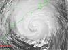
Take a look at the plot (see attached). We've got the classic comma shape to that central convective zone now. But more interesting is that ring of very deep around a slightly lesser convection. Anyone else think the CoC is relocating there?
|
Beaumont, TX
Storm Tracker
Reged:
Posts: 318
|
|
I don't think most of us have shutters here in Texas. But we are keeping an eye on Dolly. I do not think a Texas landfall down the road can
be ruled out. Depending on how Dolly fairs over the Yucatan and how much she strengthens in the Gulf, lots of factors at play here.
|
LoisCane
Veteran Storm Chaser

Reged:
Posts: 1237
Loc: South Florida
|
|
http://www.ssd.noaa.gov/goes/east/carb/loop-wv.html
If you look at the WV loop (or any loop right now) you will see Dolly pulse up and intensify at the same time that Cristobal seems to have and even a weak Cristobal can influence Dolly some if the ULL has died out and the high... not sure on the high but on any loop... floater or carib or GOM you can see an eye like, center like.. forming.
Not sure what the will do cause you can't just up it 5mph and be conservative if an eye like feature (eye LIKE) which would imply Dolly is rapidly intensifying.
And.. timing is off here and whenever you are off on timing you are often also off on intensity forecasting.
--------------------
http://hurricaneharbor.blogspot.com/
|
weathernet
Storm Tracker
Reged:
Posts: 296
Loc: Elsewhere
|
|
Ed - Just to piggyback on the surface data you just stated, one of my favorite sites for satellite is Nasa's, in which i'll attach the link. Looking at the 2:15 pic, but moreso the recent loop, there seems little doubt to me that what appears as an eye is forming, and that in the short term it is indeed appearing to be moving NNWward.
Let see if this works.....http://weather.msfc.nasa.gov/GOES/
I like this link a lot because one can not only choose whether one wishes to view a loop, but permits one to "zero in", click, and get REALLY close. Several use options are available, including a short to quite a long loop option.
As a quite thought, regarding Dolly and Bertha....., and Cristobal...., does anyone have the date which might indicate the last year ( and how many years since such data was collected ), that we had 3 named active storms occuring at the same time, but specifically in the month of July?? Would appreciated the feedback
|
Hugh
Senior Storm Chaser
Reged:
Posts: 1060
Loc: Okaloosa County, Florida
|
|
Eye-like features can be deceptive, so the is likely to be very conservative so as to not send shockwaves throughout everywhere. Yeah, honestly, it looks like a hurricane, but unless they have VERY concrete evidence to say it IS a hurricane, they won't increase the winds above 60mph I don't think.
--------------------
Hugh
Eloise (1975) - Elena and several other near misses (1985) - Erin & Opal (1995) - Ivan (2004)
|
LoisCane
Veteran Storm Chaser
Reged:
Posts: 1237
Loc: South Florida
|
|
How bout little tail like features:
http://www.ssd.noaa.gov/goes/flt/t2/avn-l.jpg
Possibly Cristobal is tugging at her as he starts to head off to the NE... and then she will move more NW like again?
Seen this feature for a while on a few views...
WV has a few band like features forming
http://www.ssd.noaa.gov/goes/east/carb/loop-wv.html
--------------------
http://hurricaneharbor.blogspot.com/
|
Ed Dunham
Former Meteorologist & CFHC Forum Moderator (Ed Passed Away on May 14, 2017)
Reged:
Posts: 2565
Loc: Melbourne, FL
|
|
The NASA site at Marshall is excellent - I've used it for years - and I did note the eyelike feature, but refrained from mentioning it - for the moment (I too need a little more data). Regarding the July question, see the latest Met Blog and check those years against the UNISYS database. Remember that we don't officially have three storms going at once since Bertha is now .
ED
|
Random Chaos
Weather Analyst
Reged:
Posts: 1024
Loc: Maryland
|
|
Speaking of July records, has included the wave still over Africa in their Tropical Weather Outlook with a medium chance of development. When was the last time we saw a about a wave that hadn't even left Africa yet?
(sorry for the somewhat off topic...)
NHC is having a time with Dolly. Latest discussion says "it may not still be a TS due to lack of a closed low." And clearly if you relocate a closed low under that main convective zone, pops up with a high end TS. Hmm. Going to be interesting.
Edited by Random Chaos (Sun Jul 20 2008 11:05 PM)
|
Ed Dunham
Former Meteorologist & CFHC Forum Moderator (Ed Passed Away on May 14, 2017)
Reged:
Posts: 2565
Loc: Melbourne, FL
|
|
Its not off-topic. I mentioned this wave in the leadoff article for this thread.
Regarding the latest bulletin, they seem to cover the bases well and given the shear in the area, I'm not sure that I wouldn't have taken the same approach:
"THE INTENSITY
FORECAST ASSUMES THAT THERE WILL BE SOME DISRUPTION OF THE SYSTEM
OVER THE YUCATAN...WHICH COULD BE AVOIDED IF A CENTER REFORMS TO
THE NORTH WITHIN THE DEEP CONVECTION."
ED
|
LoisCane
Veteran Storm Chaser
Reged:
Posts: 1237
Loc: South Florida
|
|
Listen wouldn't want to have to write the 11pm but think it's too conservative and direction is "forecasted" not consistent with current movement but this is the way they work. Forecasted means they expect it to move to the NW even if they see it looks a bit more NWN thus the phrase forecasted movement.
Imagine the biggest problem is going with what you see vs what was forecasted.
One of those storms where you see with your eyes something other than the official track (much like Irene in a way but not saying this is anything like Irene) where you have a weather mass moving on sats in a different direction from where the says the center is..
Imagine they will be watching models over the next several hours carefully.
A lot I could say but I'm going to wait and see in the morning.
--------------------
http://hurricaneharbor.blogspot.com/
|
Hugh
Senior Storm Chaser
Reged:
Posts: 1060
Loc: Okaloosa County, Florida
|
|
Quote:
Listen wouldn't want to have to write the 11pm but think it's too conservative and direction is "forecasted" not consistent with current movement but this is the way they work. Forecasted means they expect it to move to the NW even if they see it looks a bit more NWN thus the phrase forecasted movement.
It's also too based upon things that just do not seem to be the case anymore. I agree that I would not want to have to write it, but they could have done a more thorough job of explaining what was really going on, particularly in the discussion.
--------------------
Hugh
Eloise (1975) - Elena and several other near misses (1985) - Erin & Opal (1995) - Ivan (2004)
|
LDH892
Meteorologist
Reged:
Posts: 13
Loc: Carolinas
|
|
I agree with the posts about the recent track of Dolly, being more north-northwestward than pure northwestward, and the fact that didn't modify their 11pm forecast for the difference in initial position. It appears from the IR loop that Dolly is at ~20.5N, 85W, off a bit from the 11pm initial coordinates of 19.6N, 85.8N. Franklin did state that... "IF A CENTER REFORMS TO THE NORTH WITHIN THE DEEP CONVECTION"... the intensity forecast could be off if Dolly misses the Yucatan, so the hurricane specialist have noticed the recent change in motion/change in location of the low-level circulation center. As we all see, forcing consistency between forecasts sometimes produces errors. Observations should trump model output, but when the observed phenomenon is also highly erratic, errors are bound to occur. If Dolly continues to strengthen the next several model runs will become more realistic as they get a better handle on what Dolly is up to. Those interests in TX should keep a close eye on Ms. Dolly.
|
metwannabe
Weather Hobbyist

Reged:
Posts: 92
Loc: NC
|
|
I had mentioned early tonight that on WV Sat loop you could see a "surge" of moisture northwestard or a bulge if you will, towards the northwest GOM and I thought this would indicate the direction that Dolly would move, at least in the short term. I can still see this on the most recent WV Loop and it certainly appears that most posting here believe she is moving in a NNW/NW direction. Without a definite center pos. it is difficult to be sure but I just do not see the LLC passing over land tonight. In fact I would not be surprised if later a center is fixed further north and we see a dramatic shift in model runs.
Systems that look this good on sat but still developing...not only frustrating, but can be down right scary for anyone that lives around GOM!
--------------------
Fran, Bertha, Dennis & Floyd (Tag Team)
|
Storm Hunter
Veteran Storm Chaser

Reged:
Posts: 1370
Loc: Panama City Beach, Fl.
|
|
agree with a few others on here... i think... and this is based on cancun radar and sats (if you look at the loop in the last few hrs.. looks like the center may have reformed just ne of cozumel, MX... cuz the radar data is low there.. closer to the radar scan)..... putting cancun under the gun more... my thought was the farther north away from the affects of the ULL to the west would be a better chance of getting its act together... from the surface to upper levels... which would let the convection blossom more and spiral out... giving it a shot at forming a better structure.... plus dolly is in the southern part of the loop current.. so the fuel is there... i just think the conditions in the SW GOM will support a strong system, once it clears the yucatan in the morning...
**side note.. AF Recon is over Charleston, SC at 24kft headed to Cristobal** I think Cristobal finally hit the Gulf Stream this evening 
--------------------
www.Stormhunter7.com ***see my flight into Hurricane Ike ***
Wx Data: KFLPANAM23 / CW8771
2012== 23/10/9/5 sys/strms/hurr/majh
Edited by Storm Hunter (Mon Jul 21 2008 12:02 AM)
|
typhoon_tip
Meteorologist
Reged:
Posts: 576
|
|
Quote:
It indeed does look like a center relocation is taking place. Winds at Cozumel are out of the east northeast and rather light - perhaps influenced by the remnant low level center now well to the west southwest of the reforming center. The SLP at Cozumel has leveled off over the past four hours. A small but well defined appears to be forming over the earlier mid-level vortex. At 02Z I can roughly place a center at 20.7N 85.1W that is moving slowly to the northwest toward the Yucatan channel - around the northeastern perimeter of the upper level low to the southwest - but I've been fooled before by developing systems - particularly in this area. Sure seems like a stronger system with a northward position adjustment is in order.
ED
Yes! I definitely agree with this post. I was just about to post regarding the subject matter and pinged this just in time!
|
typhoon_tip
Meteorologist
Reged:
Posts: 576
|
|
Quote:
agree with a few others on here... i think... and this is based on cancun radar and sats (if you look at the loop in the last few hrs.. looks like the center may have reformed just ne of cozumel, MX... cuz the radar data is low there.. closer to the radar scan)..... putting cancun under the gun more... my thought was the farther north away from the affects of the ULL to the west would be a better chance of getting its act together... from the surface to upper levels... which would let the convection blossom more and spiral out... giving it a shot at forming a better structure.... plus dolly is in the southern part of the loop current.. so the fuel is there... i just think the conditions in the SW GOM will support a strong system, once it clears the yucatan in the morning...
**side note.. AF Recon is over Charleston, SC at 24kft headed to Cristobal** I think Cristobal finally hit the Gulf Stream this evening
It seems we have a slightly vertically tilted system. The mid-level circulation is even somewhat more NE of the low level "apparent" relocation. It makes sense that this would take place given to the shear imparted by the pulling west.
|
Storm Hunter
Veteran Storm Chaser
Reged:
Posts: 1370
Loc: Panama City Beach, Fl.
|
|
oh yeah.. guess i should of mentioned i was checking the obs there at the surface... in Cancun, Cozumel, and the bouys.. and was coming up with my estimate on dolly. I would think if what is happening is true, then dolly could be making landfall in a few hrs?
Recon is just south of morehead city, descending in alt. down to 15kft from 24kft... i very interested to see what they find in cristobal
UPDATE... there 20 miles se of Cape Lookout at 5kft and already have 35mph winds.. inbound to center
Please check your aircraft altitudes. 5 feet is below minimums.~danielw
CORRECTED.. to 1,579 meters.... sorry
Edited by Storm Hunter (Mon Jul 21 2008 12:50 AM)
|
scottsvb
Weather Master
Reged:
Posts: 1184
Loc: fl
|
|
I would think its about to make landfall in the next hour or 2...its just E of Cancun and SW of the main area of convection (but catching up to it and the midlevel support)...thus very minimal land interaction will take place as its been moving more NNW due to the upper low sliding S. This has a chance to become a hurricane later tonight (monday night) into Tuesday morning as condition will be just about perfect for development.
|
Storm Hunter
Veteran Storm Chaser
Reged:
Posts: 1370
Loc: Panama City Beach, Fl.
|
|
agree with ya there scott on Dolly
i just spent the last half hour looking at cristobal... and i think we have the samething going on with it too... i'm watching the recon flight... and looking at ground nexrad from Morehead City... i think we have two centers... a weaker surface center and a stronger mid level center on this system.
this might help show what i'm talking about
--------------------
www.Stormhunter7.com ***see my flight into Hurricane Ike ***
Wx Data: KFLPANAM23 / CW8771
2012== 23/10/9/5 sys/strms/hurr/majh
Edited by Storm Hunter (Mon Jul 21 2008 12:42 AM)
|
MikeC
Admin
Reged:
Posts: 4620
Loc: Orlando, FL
|
|
Staring at a few satellite images and the Cancun radar loop (swing mode), it certainly appears like it's just going to clip the northern tip of the Yucatan just on the north side of Cancun. It may be an interesting morning if that proves out.
|


 Threaded


