MikeC
Admin
Reged:
Posts: 4622
Loc: Orlando, FL
|
|
5:30 PM Update
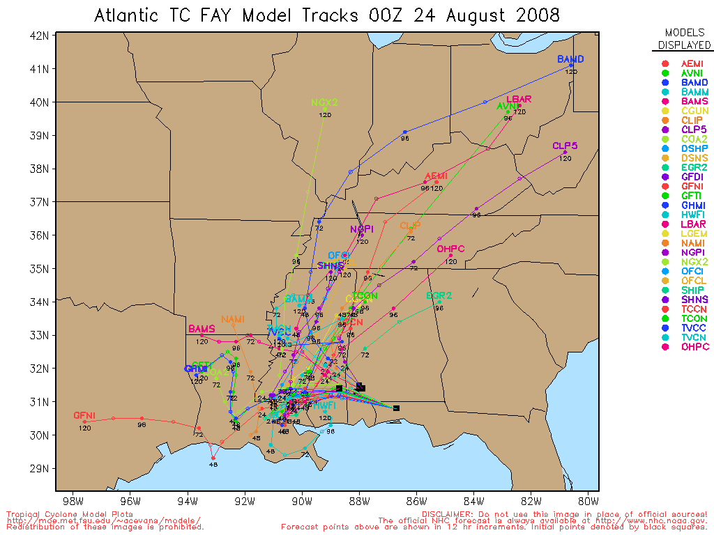
Tropical Storm Fay's 5PM Forecast still take it into the Southwestern coast of Florida as a Strong Tropical Storm or minimal hurricane, there remains some deviation on exactly where and how strong, but the bottom line is that tonight and tomorrow will be nasty here in Florida, late tomorrow afternoon will the "worst" for Central Florida.

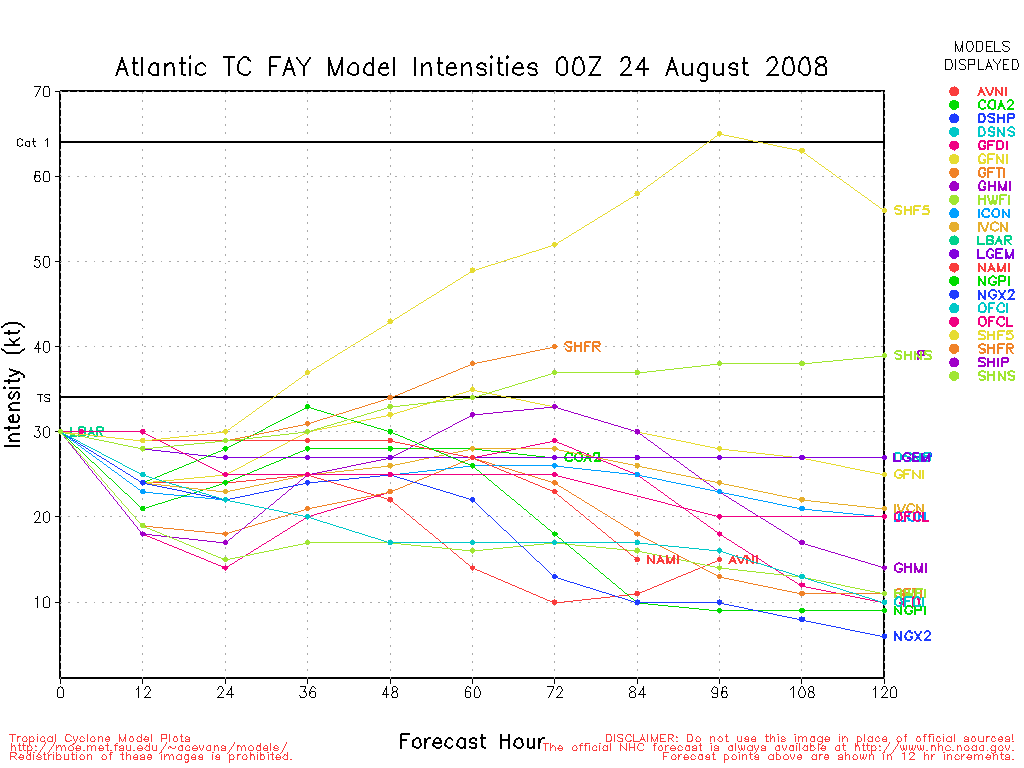
It appears that Fay is fighting some shear and dry air, and that is keeping it from strengthening too much, but Fay is still gaining strength.
We have a few discussion threads going on Fay, if you would like to discuss Fay's possible impact on Florida, check out here, if you want to let people what you think, or have a gut feeling, or want to shoot the breeze on Fay do that in the Fay forecast Lounge Want to let us know about conditions in your area, any closings, notices, or evacuations, let pass it along in this area. This is done to attempt more order during the flood of information (both good and bad) that will come over the next few days. The main comments are usually for discussion of what the storm is doing now, or will likely be short term.
Elsewhere in the tropics a wave in the central Atlantic (94L) may become a depression in the next few days.
Original Update
Tropical Storm Fay is gaining strength approaching the Florida Peninsula, it is now approaching the Keys.
Please pay attention to local media and officials in your area as the storm approaches. As of 2PM Fay is still a Tropical Storm. For state information, check out the local NWS advisories on the top of the main page and Floridadisaster.org.
HCW Level 3 Radar Recording of Fay
Mark Sudduth over at HurricaneTrack is out in Southwest Florida now, tracking the storm in his vehicle.[/url]
More to come soon...
General Fay Related Links:
Southwest Florida Webcams / hurricanecity
Florida Emergency Management / floridadisaster.org
Cuban Radar Flhurricane Recording of Cuban Mosaic radar
Southeastern US Radar Mosaic
Emergency Management/County info
Florida County Websites (South to North along the West Coast):
Monroe County Emergency Management (Florida Keys)
Collier County, FL (Naples)
Lee County, FL (Ft. Myers)
Charlotte County, FL
Sarasota County, FL
Manatee County, FL
Pinellas County, FL (St. Petersburg)
Hillsborough County, FL (Tampa)
Paso County, FL
Hernando County, FL
Citrus County, FL
Levy County, FL
Other Florida County Emergency Management Websites
State of Florida Division of Emergency Management/floridadisaster.org
Forecast Discussions for (Show All Locations):
Tampa,Miami, Key West, Melbourne
Tallahassee
"Spaghetti" style model plots from Colorado State / Jonathan Vigh
Local Newspapers/Websites
Naples News
St. Petersburg Times (Tampabay.com)
Florida Today (Brevard County)
Orlando Sentinel
Tampa Tribune
Palm Beach Post
Miami Herald
Daytona Beach News Journal
News Press (Southwest Florida)
Storm Animation of what a storm passing just north of Tampa would do to Tampa Bay
Dominican Republic Radar (Flhurricane Recording/Loop of this Radar)
Fay plotted on Google Map
|
MikeC
Admin
Reged:
Posts: 4622
Loc: Orlando, FL
|
|
Hey all I've done all I can for now in trying to get the site back running again. Likely we'll need replacement hardware to fix it longer term, but it should hold for now.
We did hit a new record for concurrent users today, 2780.
Fay looks like it's still on track to give us a good dose of rain and some wind throughout tomorrow, it still may become a minimal hurricane before landfall in Southwestern Florida.
|
Rich B
British Meteorologist
Reged:
Posts: 498
Loc: Gloucestershire, England, UK
|
|
Satellite imagery shows Fay is becoming somewhat better organised, with a possible developing over the LLCC and a continued drop in pressure - down to 1001mb according to Recon. As the worst of the conditions are northeast of the centre much of the southern Florida peninsula look set to take quite a pasting, even though she is still just a Tropical Storm. Given the drop in pressure and the improvement in organisation we will probably be looking at Hurricane Fay within the next 6 to 9 hours.
--------------------
Rich B
SkyWarn UK
|
Geoff
Weather Hobbyist
Reged:
Posts: 50
Loc: Tampa, FL
|
|
Is it just me, or does it look like Fay is moving west? The KW Radar loop sure makes a case for it. I hope it's just a slight bobble...
http://radar.weather.gov/ridge/radar.php?rid=BYX&product=N0R&overlay=11101111&loop=yes
|
Rich B
British Meteorologist
Reged:
Posts: 498
Loc: Gloucestershire, England, UK
|
|
She must have wobbled more to the west as she made landfall over Key West at 300EDT. Latest recon shows pressure down to 999mb, with the becoming more defined too. Hurricane Fay soon i think!
--------------------
Rich B
SkyWarn UK
|
bradrd
Registered User
Reged:
Posts: 4
|
|
That is not a wobble it is the storm building on the west side.I thought even a met would know that.Hope it turns soon to the east and gets from the gulf
|
Storm Hunter
Veteran Storm Chaser

Reged:
Posts: 1370
Loc: Panama City Beach, Fl.
|
|
deleted
--------------------
www.Stormhunter7.com ***see my flight into Hurricane Ike ***
Wx Data: KFLPANAM23 / CW8771
2012== 23/10/9/5 sys/strms/hurr/majh
Edited by Storm Hunter (Mon Aug 18 2008 04:21 PM)
|
Storm Hunter
Veteran Storm Chaser
Reged:
Posts: 1370
Loc: Panama City Beach, Fl.
|
|
i was a little shocked, called landfall that early over key west... I see recon may have hit a 998mb just to the SW of key west by about 10 miles.... will see in a bit when dropsonde data comes in. The area of lowest pressure i think... was near 24.37N 81.85W I have noticed now that Fay appears to be dropping about 1mb an hour now?
--------------------
www.Stormhunter7.com ***see my flight into Hurricane Ike ***
Wx Data: KFLPANAM23 / CW8771
2012== 23/10/9/5 sys/strms/hurr/majh
|
Rich B
British Meteorologist
Reged:
Posts: 498
Loc: Gloucestershire, England, UK
|
|
At 200pm the centre was 20 miles SE of Key West, moving NNW at 13 mph. To landfall over Key West the centre would have had to move NW. This would indicate a wobble to the west, in part due to the improving organisation on that side of the circulation.
--------------------
Rich B
SkyWarn UK
|
Thunderbird12
Meteorologist
Reged:
Posts: 644
Loc: Oklahoma
|
|
Winds went calm at Key West at the reported time of landfall, but since then, the winds have been out of the ESE, which would normally indicate that the center is still somewhere to the SW. Also, the pressure at the station dropped from 1001.3 mb at the time of reported landfall (3 pm EDT) to 999.3 mb an hour later. Overall, the center still seems to be somewhat broad and diffuse, which should prevent any rapid intensification for the near future, though some modest intensification seems to be underway.
|
West FL Jess
Weather Hobbyist

Reged:
Posts: 50
Loc: Tampa Bay
|
|
it appears as though some of the models are moving a touch West and then have Fay heading back into the Gulf...any thoughts on this? I think the 5PM Advisory might be a little more West then before.
~jess~
--------------------
~jess~
|
BillD
User
Reged:
Posts: 398
Loc: Miami
|
|
They corrected the landfall issue in the 5:00 discussion. Currently the center is more or less over Key West (it wasn't before). Pressure at Key West and Sand Key is just over 998, however the winds have dropped a bit. Fay is strengthening as predicted. The is continuing to expand. Winds should pick up in response to the pressure drop.
Bill
|
B_from_NC
Verified CFHC User
Reged:
Posts: 23
Loc: Raleigh, NC
|
|
What an amazing shot of Fay... Link
She is shooting straight up into the sky. This view in 3-d would be incredible. Not too often you get to see the base of the storm spinning along with the cloud tops.
She kinda looks like a top right now with a slight wobble as well...
--------------------
Lived in S. Fla from '90-'07...
Put up and took down way too many hurricane shutters!
|
MikeC
Admin
Reged:
Posts: 4622
Loc: Orlando, FL
|
|
Just a site update, was able to track down one cause of the trouble today, and fixed it, now will be monitoring if it was the only problem. I do know there is some hardware replacement involved for the future, but we've rigged the site now to use some backup systems. Hopefully now I can spend more time watching Fay itself rather than the servers.
Thanks to the donators for the help in keeping it all going.
|
MichaelA
Weather Analyst

Reged:
Posts: 951
Loc: Pinellas Park, FL
|
|
It certainly looks like the convection is trying to wrap around the center in the latest vis sat images. I'm not expecting too much of an impact in the Tampa Bay area, but I'm also keeping in mind that any slight track wobble will mean big local changes.
Welcome back to the interwebs, !
--------------------
Michael
PWS
|
craigm
Storm Tracker

Reged:
Posts: 327
Loc: Palm City, Florida
|
|
Mike-- I will personally spearhead a fund riser for new equipment when the dust clears from this storm - feel lost when this site is down.
Anyway, amazing amount of energy for a tropical storm. We have been getting slammed all day on the east coast and the storm is still a long way off. Fay is definately strengthening and am debating whether to put shutters up before dark just to be safe--
--------------------
Why I'm here:
Weather hobbyist
|
StrmTrckrMiami
Weather Guru

Reged:
Posts: 148
Loc: Manchester, NH
|
|
Quote:
It certainly looks like the convection is trying to wrap around the center in the latest vis sat images. I'm not expecting too much of an impact in the Tampa Bay area, but I'm also keeping in mind that any slight track wobble will mean big local changes.
Welcome back to the interwebs, !
Why does it keep going down? I'll fund raise for a new server too lol
--------------------
Tracking Storms Since 2004
Miami, Cocoa, Fort Myers and Jacksonville
Currently Reside in New England
|
JMII
Weather Master

Reged:
Posts: 509
Loc: Margate, Florida
|
|
She is really blowing up on the west side, pressure is still dropping in Cudjoe Key ( http://www.wunderground.com/weatherstation/WXDailyHistory.asp?ID=MC0925 ) which surprised me as I thought the center had already cleared Key West. She just might make it to hurricane status after all.
--------------------
South FL Native... experienced many tropical systems, put up the panels for:
David 79 - Floyd 87 - Andrew 92 - Georges 98 - Frances 04 - Wilma 05 - Matthew 16 - Irma 17
Lost our St James City rental property to Ian 22
|
MichaelA
Weather Analyst
Reged:
Posts: 951
Loc: Pinellas Park, FL
|
|
These weaker storms can be nasty, especially away from the center. Watch those squalls coming in from the water. Small, fast moving tornadoes are a concern with these types of systems when they interact with land.
--------------------
Michael
PWS
|
WeatherNut
Weather Master
Reged:
Posts: 412
Loc: Atlanta, GA
|
|
Thats a pressure of 996.9 there and they are not even in the center right now.
Also...looking at KW radar it shows the center moving almost DUE EAST????? That would explain lower pressure east of Key West
--------------------
Born into Cleo (64)...been stuck on em ever since
Edited by WeatherNut (Mon Aug 18 2008 06:27 PM)
|


 Threaded


