MikeC
Admin
Reged:
Posts: 4570
Loc: Orlando, FL
|
|
4:45 PM EDT 6 August 2011 Update
Recon aircraft found enough of a center to classify the remnants of Emily as a tropical Depression, and it currently is moving north and is expected to begin moving northeast tonight. The center is located just to the west of little Abaco island. No watches or warnings have been put up, and the rain appears to be mostly in the Bahamas, and for the most part, stay away from the Florida Coastline.
This coming week the topic will likely be the wave exiting the African coastline, this has multiple model support for a long track storm, that isn't a sure bet to recurve at the moment.
11:45 AM EDT 6 August 2011 Update
The Remains of Emily have finally begun consolidating around a more dominant center area over the past 12-18 hours, and a definitive Low has formed just north of Andros Island - about 140 miles east-southeast of Miami, Fl.
At this time surface pressures do not yet seem to be falling much if at all in the area, but then the available buoys, ships, personal weather stations and the like are not even within a 50 mile radius of this guestimated center. The appearance on satellite and radar do suggest that a depression could be forming today.
An Air Force plane is scheduled to investigate this area this afternoon, and so we should have a clearer picture of what is going on at that time. Either way, given that the Remains of Emily have "jumped," and reformed cohesively a good clip to the northeast of where it was being tracked just yesterday, the odds of it affecting Florida directly have come down - and considering its present location it is no surprise that models now forecast whatever is out there to recurve out to sea. However, given the Low's very close proximity to the state, not to mention several islands and many boating interests, it is worth watching; it is also worth noting that less than a day's worth of deviation from those model's forecasts could easily take more inclement weather inland over south Florida.
-Ciel
4:45 PM EDT 4 August 2011 Update
The last official advisory on Emily has been issued, no more advisories will be issued on the system unless it regenerates, (not terribly likely, perhaps a 1 in 4 chance of happening). Still flooding rains are going on in Haiti now. We'll watch the remains of the system for another day.

The remains are forecast to spread toward the west northwest over eastern Cuba an enter the Bahamas, similar to earlier forecast tracks. If it were to regenerate, it probably wouldn't be until tomorrow night or Saturday.
2:45 PM EDT 4 August 2011 Update
Latest Best Track file from the National Weather Service now references Emily as a wave again, it looks very likely that Emily will be downgraded at 5PM.
2PM EDT 4 August 2011 Update
Emily's center of circulation has landed on Haiti, and the disruption in outflow was nearly immediate. Hispaniola has a good shot to weaken the system further, and possibly back to an open wave (below depression) status. This would be good news for Florida as it would bring more rain and less wind to the coast.
There is less than a 50/50 shot it can regain after it passes Hispaniola, it will still need to be watched to see how much of it remains.
Original Update
Tropical Storm Emily may be finally moving west northwest based on recon reports overnight, and although continually bursting with convection, the system has been affected by land, dry air, and some shear near Cuba keeping the northern side of the system relatively weak. However, the western side of the storm has gained more convection overnight, and the general core of the system is much better than yesterday.
Still the northern side of the system is bringing very large amounts of rain to Haiti and the Dominican Republic that will continue through most of today.

The current forecast track is basically unchanged, and the idea that not too much is known until the system gets out of the Caribbean is still there. There remains a small chance the system dissipates entirely before going further north, but it still seems unlikely.
The good news for Florida this morning is that the forecast models, with the NOAA jet data, has shifted to the east, lessening the chances for a Florida landfall a good bit. Odds do not favor a landfall along the east coast, but the chance still remains, if the move north has begun (which recon may verify later today) the chances lessen greatly. Odds favor the system stays offshore, and brings strong surf to the east Coast of Florida, but the system itself will likely move through the Bahamas as a Tropical Storm..
If for some reason the system stays on a more westerly course today, the possibility a tropical storm watch goes up for south Florida still exists, but appears unlikely at present since most of the tropical storm force winds would be on the eastern side. It would be late today or tomorrow for watches primarily because of the storm's current slow movement. Florida must continue to monitor it until a definitive northerly motion has begun, and the system exits the Caribbean. There is still an unusually large lack of clarity with this system.
Want to read Speculation, and best guesses? Check out the Forecast Lounge.
Long term Recording of Long Range Radar off Miami for Emily Remnants.
BoatUS
Dominican Republic Meteorological
Martinique Radar Recording Emily/91L Approach (flhurricane)
Long term recording of Emily Floater Water Vapor Imagery (flhurricane)
Long term recording of Emily Floater Visible Imagery (flhurricane)
Long term recording of Caribbean Water Vapor Satellite Imagery of Emily (flhurricane)
Other Florida County Emergency Management Websites
State of Florida Division of Emergency Management/floridadisaster.org
Forecast Discussions for (Show All Locations):
Tampa,Miami, Key West, Melbourne
Tallahassee
Edited by cieldumort (Sat Aug 06 2011 04:51 PM)
|
Random Chaos
Weather Analyst

Reged:
Posts: 1024
Loc: Maryland
|
|
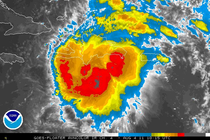
Looking at Emily's last couple of IR frames, outflow looks to be improving and the classic comma shape appears to be developing with what appears to be a COC just south and slightly east of the Haiti/Dominican Republic border. In the graphic below, you can clearly see what appears to be a comma like feature spreading out west of the COC.
Storm looks to be intensifying a little, question is: is it actually getting better organized as appears on satellite IR? Given it's past behavior, I wouldn't say yes until we have a recent microwave pass or a recon in the storm.
|
Owlguin
Weather Hobbyist
Reged:
Posts: 68
|
|
I'd agree, and it's barely moving if at all.
Edited by Owlguin (Thu Aug 04 2011 07:25 AM)
|
MikeC
Admin
Reged:
Posts: 4570
Loc: Orlando, FL
|
|
Based on the long Water Vapor loop it appears Emily is moving generally westward along south of Hispaniola as if to avoid it, with the north side a bit affected by the island, the rest, like you said is looking a lot better. It's still fighting the twin nature from days back, and until that influence is completely purged it will likely struggle. The dry air and shear near Cuba aren't having too much of an affect. The water vapor hints at a weakness in the ridge to the north (East of the northern Bahamas), but it's not clear if Emily will go for it yet or not.
Still no obvious move northward since it's been south of Hispaniola.since when it was near 70W. Water vapor remains probably my favorite satellite view to see whats going on around the system. Emily is expanding, though, which has made tracking movement difficult ever since the LLC went back under convection.
|
Rich B
British Meteorologist
Reged:
Posts: 498
Loc: Gloucestershire, England, UK
|
|
The 8am intermediate advisory puts the pressure down 1mb to 1005mb, and Emily is meandering. however, recon are in the system now and have just reported a central pressure down to 1003mb.
--------------------
Rich B
SkyWarn UK
|
doug
Weather Analyst
Reged:
Posts: 1006
Loc: parrish,fl
|
|
I agree the WV is the tool of choice to see the synoptic pattern immediately surrounding the system. Right now that picture tells a story of the weakness in the Atlantic ridge north and east of the islands and the cyclonic flow covering the Carribean to the west. There seems to be two choices: the system begins to move toward the weakness in the Atlantic, or is pulled wnw toward the weakness between the Carribean ULL and the ridge over the SE US which lies in the Florida straits. There is little in the way of cloud movement north and west of the system to see how those flows are working but a few images did pop up NW of the system and they seem to be moving NW toward the Florida straits. ( Drop sonds will answer these questions later today probably). I am not saying that is predictive, but it is the type of immedite visual evidence to watch for that can signal a future track.
--------------------
doug
|
adam s
Verified CFHC User
Reged:
Posts: 20
|
|
I have no confidence with the models of Emily. The models keep changing and not any model called for a stalling or stationary system. If emily moves west It will get closer to the United States. Where Emily goes now is anybody's guess. I dont think the knows where Emily will go.
|
JMII
Weather Master

Reged:
Posts: 495
Loc: Margate, Florida
|
|
This is twice now that Emily has stalled despite the models saying she should go NW, thus their guidance is suspect. Outflow looks like its improving and the ridge over the SE US appears to be weaker today. The core of Emily is still a mess, not sure if its the mountains, the shear or the dry air, but all convection N to NW of the storm is gone. Hard to gauge any motion due to lack of any defining center like structure. Its still a complete toss up as what is going to happen, the good news is this slow motion means she is still several days away from the US and unless she steers clear of two land masses one can assume a weak storm is all we'll see.
However I wouldn't be shocked to see her shoot the gap and intensify, then just as suddenly be swept out to sea. Or drag west over the Cuba and die off completely. Currently she appears to be stuck against the shear that she was fighting yesterday, but there is a weak spot ahead (about the 2PM Friday forecast position)... so it looks like we have another 24 hours of wait-n-see before any firm assessment can be made.
--------------------
South FL Native... experienced many tropical systems, put up the panels for:
David 79 - Floyd 87 - Andrew 92 - Georges 98 - Frances 04 - Wilma 05 - Matthew 16 - Irma 17
Lost our St James City rental property to Ian 22
|
scottsvb
Weather Master
Reged:
Posts: 1184
Loc: fl
|
|
I didnt see a vortex for a 1003mb .. you might of been looking at yesterdays vortex from last night.
I think Emily is actually worse off than 12-24hrs ago. Arc clouds being blown out... less
of a W wind (but still there) also no concentration of T-Storms... I would suspect the pressure
is up to about 1008mbs the way it looks to me right now.
|
doug
Weather Analyst
Reged:
Posts: 1006
Loc: parrish,fl
|
|
Satellite imagery seems to suggest a WNW movement has begun.
--------------------
doug
|
MichaelA
Weather Analyst

Reged:
Posts: 946
Loc: Pinellas Park, FL
|
|
Quote:
Satellite imagery seems to suggest a WNW movement has begun.
I'm not seeing that just yet. It still looks to be more generally westward on the latest floater vis loop.
--------------------
Michael
PWS
|
danielw
Moderator

Reged:
Posts: 3526
Loc: Hattiesburg,MS (31.3N 89.3W)
|
|
Per Discussion one of the overnight flights had avionics problems. And it appears that they may have slipped the backup aircraft in for a while. I see a short mission.
RichB was referring to the following measurement:
11:37:30Z 17.133N 71.883W (~ 4,984 feet) altitude 1003.1 mb extrapolated pressure(~ 29.62 inHg)
Winds from 321° at 5 knots (From the NW at ~ 5.8 mph)
The next 30 second observation indicates they passed through the Center. Wind shift from NW to SW
|
scottsvb
Weather Master
Reged:
Posts: 1184
Loc: fl
|
|
NHC likes the Sat presentation of the system compared to yesterday at this time.. I agree.. but not from 12hrs ago. I think the pressure is very generous at 1004mb until recon goes in. I would think it's at 1007-1008mbs.
I'm hesitant also on putting up TS watches for Florida (till 5pm report)..after all..a TS Watch is just that.. A Watch would mean conditions could support a TS in that area within 60hrs. (if I can remember the change from 48-60 now..
Anyways..cant wait for next recon.
|
danielw
Moderator
Reged:
Posts: 3526
Loc: Hattiesburg,MS (31.3N 89.3W)
|
|
Tropical Storm Watch:
An announcement that tropical storm conditions (sustained winds of 39 to 73 mph) are possible within the specified area within 48 hours.
Tropical Storm Warning:
An announcement that tropical storm conditions (sustained winds of 39 to 73 mph) are expected somewhere within the specified area within 36 hours.
http://www.nhc.noaa.gov/aboutgloss.shtml
|
scottsvb
Weather Master
Reged:
Posts: 1184
Loc: fl
|
|
ahh okay. Yes I remember now... brain drained.. lol. I wasnt 100% on the TS watches if they increased slightly.
|
MikeC
Admin
Reged:
Posts: 4570
Loc: Orlando, FL
|
|
Nothing has really changed since this mornings update, until the storm clears the Caribbean it's mostly a guessing game. The western side of the storm is fairly weak, so it could get as close as 40-50 miles offshore of Florida to the east and be fairly tame outside (a little squally, but not bad).
|
danielw
Moderator
Reged:
Posts: 3526
Loc: Hattiesburg,MS (31.3N 89.3W)
|
|
Quote:
ahh okay. Yes I remember now... brain drained.. lol. I wasnt 100% on the TS watches if they increased slightly.
Emily is quite the Brain Drainer, and Nerve wrecker, too. Almost as much as a television drama.
BTW. I'm watching a low level swirl in the E GOM. About 130 mile WSW of Tampa. It's one of many swirls in the lower levels right now in the GOM and Caribbean.
Another is located near the Dry Tortugas. And three swirls are visible around Jamaica.
Winds in the E GOM are from the NE at a decent speed so no worries there. Right now.
It appears that the leading edge of the tropical wave associated with Emily is approaching SE Andros Island in the Bahamas. That's the large island SE of Miami.

|
adam s
Verified CFHC User
Reged:
Posts: 20
|
|
Looking at this image Emily is definitly falling apart. If Emily survives another 24 hours that will be alot. All bets are off with this storm.
|
scottsvb
Weather Master
Reged:
Posts: 1184
Loc: fl
|
|
TBH I don't see any circulation with this system anymore.. its more in the 850mb and above and not all the way to the surface. I wouldn't be surprised to see a 1010mb low pressure but NO LLC in the next recon and 5pm update.
I say there is a 60% chance this will be a trough over the next 12hrs 40% stay a weak Storm... near 0% of this getting stronger than what it is for the next 24hrs.
Main factor this had was the mid level circulation was behind the LLC... at times they got close but then the LLC weakend. There were a lot of lower pressure points in this system.. Although 1 had a LLC... others 150 miles away would have a pressure drop matching the LLC and disrupting the LLC causing it to weaken.. just too many LLV causing pressure drops around the Main LLC
|
Ed Dunham
Former Meteorologist & CFHC Forum Moderator (Ed Passed Away on May 14, 2017)
Reged:
Posts: 2565
Loc: Melbourne, FL
|
|
Note that all of the bulletins are posted as drop-down windows at the top of the Main Page. We do this to eliminate the need to post these bulletins in the various Forum threads. Note also that you can copy a small portion of a particular bulletin in your post if you are going to discuss something about it.
ED
|


 Threaded


