CFHC

Reged:
Posts: 149
Loc: East Central Florida
|
|
It's July. We went through June without any named storms, or depressions to track. I don't think we'll make it through July without at least one. And our first candidate is up for bat:
On my development scale, where is it now?
code:


forget it) 0 1 2 3 4 5 6 7 8 9 10 (sure thing)


           [-----*----------------]
This system has the potential to develop, so we are watching it. I wouldn't expect it to do too much however. And it would be slow development... very slow. It first must become a definite low before I can consider it more.
Enjoy Independence Day everyone!
NASA GHCC Interactive Satellite images at:
North Atlantic Visible (Daytime Only), Infrared, Water Vapor
Some forecast models:
NGM, AVN, MRF, ETA ECMWF
DoD Weather Models (NOGAPS, AVN, MRF)
AVN, , , , , UKMET
Other commentary at Mike Anderson's East Coast Triopical Weather Center, Accuweather's Joe Bastardi, Hurricane City, Gary Gray's Millennium Weather, Even more on the links page.
- [mac]
|
GaryC
Weather Guru
Reged:
Posts: 109
|
|
I just want to be the first to wish everyone a safe and happy Fourth of July!!! Maybe when we come back from the holliday we will have something to look at. 
|
Anonymous (HF)
Unregistered
|
|
two nights of the same thing.. nothing is going on off the southeast coast. only interesting thing my model glance showed was an gulf low pressure that moves into the western gulf by early next week. phantoms i consider more possible than mrf ones, but still not worthy of much interest. have to see if it keeps showing up though (like our current no-show did) in future runs.
i looked back on the poll about activity in the rest of the early season.. more conservative than i expected. i remember lots of spring forecasts calling for 15, 16, 17 storms this season.. june must have been a reality check.
anyhow, next poll:
|
Rad
Weather Guru

Reged:
Posts: 173
Loc: St. Pete Fl. {27.8N 82.7W}
|
|
Hey HF , Redo your poll,........ I voted september.
--------------------
RIDE 2 LIVE 2 RIDE
|
Steve 777
Unregistered
|
|
I too voted september...voted high on storms also..still have time...they will be lined up come sept. Happy 4th all!!!!
|
Anonymous
Unregistered
|
|
GOOD POLL BUT IT DOES NOT HAVE A SUBMIT 
|
Frank P
Veteran Storm Chaser
Reged:
Posts: 1299
|
|
I don't think you can really judge a tropical season based on what happens, or for that matter, does not happen, in June or July... Mid August to mid September is peak of season... We may see something develop later in July, but I give it 50-50 at best... When August rolls around, especially mid Aug, then things should start getting a lot more active... especially the start of the Cape Verdi storms
If we get though Aug and early Sept with no activity then something is not right for sure and this tropical system will be a wash... But I don't see that happening. I predicted 12 named storms back in May and I am sticking to that prediction.... I except at least three to four named storms by the end of August. Four to five named storms in Sept, three to four storms in October and possibly one in November.... for a total of twelve... I can't see anymore than that, and if anything maybe one or two less.... but for the record I'm sticking with 12.... I'll save the crow for thanksgiving if need be..
Smoked Turkey, Chicken, Crow... can't tell em apart... hehe
|
Anonymous (HF)
Unregistered
|
|
i think whatever is off the east coast is teasing me.. notice there's now a discrete, small, turning convective mass moving east just to the north of bermuda. well, theres the much anticipated low, and to its northeast is another cutaway system with a surprising amount of convection given its latitude. the isnt too interested in classifying systems up there ive noticed, so unless one of these makes a quantum leap, doubtful that anything comes from them.
the possible future area of interest that i noticed last night.. bastardi mentioned today.. basically we've just got to wait for this trough to start backing and see if a gulf system tries to blow up. with all that rain in south and central texas, and the vigor of the convection, i can see a repeat system causing trouble if it does much over the gulf. the timeframe to be watching is early next week.. possibly into midweek.
lots of july to go through, and most of us expect something to happen.
the poll.. yeah, blame it on me being a distracted zombie.
the all important pollstop, and voila.
neat features cornelius bros., thanks again for hosting this site. kind regards and such.
HanKFranK 3.07 aiken, SC 0343z05july
|
Anonymous
Unregistered
|
|
Well well, two spins off the east coast---both getting sweared, with exposed circulations---one pretty close to the Carolina's--welll....
and look in the Gulf s of the Panhandle...
cooking is beginning....
IHS,
Bill
|
Anonymous
Unregistered
|
|
Sheared that is---not sweared! LOL! Maybe sweared at!
IHS,
Bill
|
Anonymous
Unregistered
|
|
And....I remember several memorable and more active seasons that started with or featured a north (NORTH!) Atlantic storm in July...stay tuned...
WHXX01 KWBC 051300
CHGHUR
DISCLAIMER...NUMERICAL MODELS ARE SUBJECT TO LARGE ERRORS.
PLEASE REFER TO TPC/NHC OFFICIAL FORECASTS FOR TROPICAL CYCLONES.
.....THE FOLLOWING IS A TEST MESSAGE.....
TROPICAL DEPRESSION INVEST (AL932002) ON 20020705 1200 UTC
...00 HRS... ...12 HRS... ...24 HRS...
020705 1200 020706 0000 020706 1200
LAT LON LAT LON LAT LON
BAMD 35.7N 62.4W 36.7N 60.8W 38.6N 58.6W
BAMM 35.7N 62.4W 36.8N 60.7W 39.1N 58.3W
A98E 35.7N 62.4W 36.3N 60.9W 38.2N 58.6W
LBAR 35.7N 62.4W 36.9N 60.5W 39.7N 58.2W
SHIP 25KTS 30KTS 35KTS
DSHP 25KTS 30KTS 35KTS
...36 HRS... ...48 HRS... ...72 HRS...
020707 0000 020707 1200 020708 1200
LAT LON LAT LON LAT LON
BAMD 41.5N 56.6W 44.7N 54.5W 49.5N 46.8W
BAMM 42.5N 55.9W 45.9N 53.0W 48.0N 42.9W
A98E 40.4N 56.4W 44.4N 54.3W 55.2N 47.7W
LBAR 43.4N 55.3W 47.1N 51.8W 46.4N 38.0W
SHIP 36KTS 37KTS 34KTS
DSHP 36KTS 37KTS 34KTS
...INITIAL CONDITIONS...
LATCUR = 35.7N LONCUR = 62.4W DIRCUR = 75DEG SPDCUR = 7KT
LATM12 = 35.4N LONM12 = 64.1W DIRM12 = 66DEG SPDM12 = 10KT
LATM24 = 35.1N LONM24 = 65.8W
WNDCUR = 25KT RMAXWD = 20NM WNDM12 = 20KT
CENPRS = 1009MB OUTPRS = 1012MB OUTRAD = 150NM SDEPTH = D
RD34NE = 0NM RD34SE = 0NM RD34SW = 0NM RD34NW = 0NM
.....THE ABOVE HAS BEEN A TEST MESSAGE.....
IHS,
Bill
|
Rich B
British Meteorologist
Reged:
Posts: 498
Loc: Gloucestershire, England, UK
|
|
Well it seems like things are finally kicking off! The system to the NNE of Bermuda has become increasingly better organised on satellite imagery today, and i think it may be declared our first Tropical Cyclone of the season at some point today. Possibly by the 5.30pm . The convection has consolidated over the apparent LLCC, with low level clouds evident to the northeast and the deepest convective activity located in the remaining 3 quadrants. I think it is too early to predict just what might happen to this system, but judging from the appearance on imagery already, i would guess it will be a strong TD, and may reach a weak TS within 24 to 36 hours. Maximum winds (now i amgoing out on a limb!) will not exceed 45 mph with this system before it weakens or gets absorbed.
As for the area to the SE of the NC coast, well it is poorly organised and i dont see much happening with it.
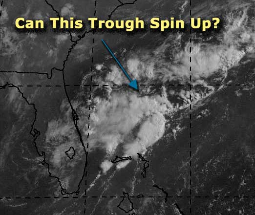
Another area of interest is that which has developed to the south of the Florida Panhandle. Poorly organised at the moment, but worth watching.
Well i will no doubt be posting again soon as this Bermuda System develops!
Rich B
StormWarn2000 IWN
--------------------
Rich B
SkyWarn UK
|
Anonymous (HF)
Unregistered
|
|
for some reason has two tracks for the same system. there have been two satelite intensity estimates on it, at 0545z this morning it got 'too weak', then at 1145z it came up at 1.0. mentally organized person that i am, ive already forgotten where to find the intensity data for a 1.0, but it's weak depression if i'm not mistaken. anyhow this system is already north of bermuda, and supposed to fuse into the larger low over the canadian maritimes. the is at least mentioning it in s but i can remember a similar system in august 2000 that they never bothered to classify, despite a gale force ship report. so this may end up being arthur, and it may not.
other items of interest.. TPC has two other systems mentioned in the .. one is even further northeast than 93L(?) but still throwing convection and pretty well organized, but almost surely not tropical in nature. it will soon become one with the low over the maritimes. the other system is a low tagged at 1014mb in the convection off the outer banks. models have it moving nne toward the same low poised to eat the previously mentioned systems.. TPC is following the avn forecast for it. right now it is poorly organized, but as with the other two, there is plenty of baroclinic kick and warm water underneath.. so it may become a short lived tropical system that harries off the coast over the weekend.
one last item of mention.. the next upper system retrograding into the gulf is forecast with a surface trough. there is consistent model support for this feature, but no model is doing much with it. bastardi mentioned this again and went on to say that the upper system will vent a future eastpac system well to the south. so, expecting a cristina on the pacific side, and probably nothing here in the atlantic, except whatever may flare off the northeast coast as it jets out.
one other mention, bastardi talked about the cooling off the south american coast. el nino is partway there but struggling.
done for now, i submit another poll:
will check back later.
HanKFranK 3.07 aiken, SC 1713z05july
|
Rich B
British Meteorologist
Reged:
Posts: 498
Loc: Gloucestershire, England, UK
|
|
HankFrank,
this system would be classified as 93L as 90L to 92L have already occured this season...
latest satelite imagery also shows the LLCC partly exposed to the northeast of the main convection, but the system still looks pretty good. Expect to put out either a Tropical Disturbance Statement, or classify this thing soon!
Rich B
StormWarn2000 IWN
--------------------
Rich B
SkyWarn UK
|
Anonymous
Unregistered
|
|
So looking at this this looks tropial and has been named 93l an dos;nt care.
|


 Threaded


