MikeC
Admin
Reged:
Posts: 4635
Loc: Orlando, FL
|
|
4AM EDT Update 8 July 2018
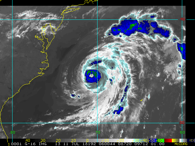
TD3 has become Tropical Storm Chris. Chris is expected to become a hurricane, and possibly a formidable one, while over the Gulf Stream.
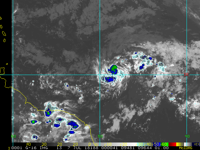
Beryl has been re-firing convection overnight in response to some westerly shear. Sometimes this can help a fledgling tropical cyclone get itself together (or together again, in the case of Beryl), and so deserves to be monitored. Interests in the Lesser Antilles should still prepare for tropical storm conditions possibly affecting some portion or portions of the islands later tonight and/or Monday.
-Ciel

4:30PM EDT Update 6 July 2018
Invest 96L has become TD 3 a few hundred miles southeast of the North Carolina coast. The cyclone may pull up nearly stationary, or just meander, and cook, over anomalously warm waters in this region for several days. A potential significant threat if it turns toward the U.S., and needs to be watched.
- Ciel
11AM EDT Update 6 July 2018
Beryl is gaining strength today and its small size has insulated it from a lot of the negative effects. The official forecast now keeps it a hurricane into the East Caribbean before weakening in the Caribbean.
Hurricane watches could be required for some islands in the Lesser Antilles by tonight. Tropical-storm-force winds are likely to begin over some of the islands by Sunday evening.
Meanwhile 96L near the NC coast could form this weekend or early next week.
Those in the Lesser Antilles should now pay very close attention to Beryl, and those in North Carolina should be monitoring the wave 96L closely.
5AM EDT Update 6 July 2018

Tiny Tropical Cyclone Beryl becomes Hurricane Beryl, the first Hurricane of the 2018 Atlantic Hurricane Season, while at a very south latitude in the Tropical Atlantic.
Elsewhere, recently Invest-tagged 96L off the southeast U.S. continues organizing, and may get listed as a Potential Tropical Cyclone, TD, or even a named storm as soon as later today, perhaps necessitating Watches and/or Warnings along parts of the east coast over the weekend and/or early next week.
For in-depth Beryl model talk and more, go beyond the cone with us in the Hurricane Beryl Lounge.
For 96L model talk and more check out the Invest 96L Lounge
-Ciel
2:30PM EDT Update 5 July 2018
Tropical Depression Two becomes Tropical Storm Beryl.
Noon Update 5 July 2018
Tropical Depression two forms in the East Atlantic, but expected to dissipate before reaching the Caribbean.
Original Update
The Atlantic Tropics are starting to show some signs of life this July, although nothing is an imminent threat to land.
First an area southeast of Bermuda that has a low, 20% chance to develop, but would remain out to sea.
Another is the area in the East Atlantic, being tracked as 95L tonight, this also has a 20% chance to develop, but will run against some unfavorable conditions.later in the week, however ultimately it may develop beyond that, so its worth watching, some models turn it into a tropical storm next week..
July expands the area we watch for development, but typically activity doesn't pick up to a serious degree until mid to late August. However, July storms can happen so we'll be watching.
Activity in the Atlantic has been fairly sparse so far this year, with the Pacific being much more active, a sign that El Nino may be a factor this year.
|
MikeC
Admin
Reged:
Posts: 4635
Loc: Orlando, FL
|
|
We've added a new self-hosted satellite floater animation for 95L (And all future storms/invests) the link is on the main page The old floater links still don't work (and may not since GOES-16 replaced the old satellite)
|
cieldumort
Moderator

Reged:
Posts: 2497
Loc: Austin, Tx
|
|

|
cieldumort
Moderator

Reged:
Posts: 2497
Loc: Austin, Tx
|
|
Reconnaissance missions have been tasked for both 96L and Beryl, starting with 96L on Saturday.
Quote:
WEATHER RECONNAISSANCE FLIGHTS
CARCAH, National Hurricane Center, MIAMI, FL.
0105 PM EDT FRI 06 JULY 2018
SUBJECT: TROPICAL CYCLONE PLAN OF THE DAY (TCPOD)
VALID 07/1100Z TO 08/1100Z JULY 2018
TCPOD NUMBER.....18-043 CORRECTION
I. ATLANTIC REQUIREMENTS
1. SUSPECT AREA (EAST OF CAROLINA COAST)
FLIGHT ONE - TEAL 71 FLIGHT - TEAL 72
A. 07/1500Z A. 08/0600Z
B. AFXXX 01AAA INVEST B. AFXXX 0203A CYCLONE
C. 07/1200Z C. 08/0300Z
D. 33.2N 74.4W D. 33.5N 74.5W
E. 07/1430Z TO 07/1830Z E. 08/0530Z TO 08/0900Z
F. SFC TO 10,000 FT F. SFC TO 10,000 FT
FLIGHT THREE - NOAA 42
A. 08/1030Z
B. NOAA2 0303A CYCLONE
C. 08/0830Z
D. 33.5N 74.5W
E. 08/1000Z TO 08/1500Z <-----DATES CORRECTED
F. SFC TO 10,000 FT
2. HURRICANE BERYL
FLIGHT ONE - TEAL 74
A. 08/1130Z,1730Z
B. AFXXX 0102A BERYL
C. 08/0830Z
D. 14.2N 56.6W
E. 08/1100Z TO 08/1730Z
F. SFC TO 10,000 FT
3. OUTLOOK FOR SUCCEEDING DAY:
A. CONTINUE 12-HRLY WC-130 FIXES FOR SUSPECT SYSTEM.
B. NOAA 42 P-3 TDR MISSIONS EVERY 12 HRS FOR SUSPECT SYSTEM.
C. CONTINUE 6-HRLY FIXES FOR BERYL IF SYSTEM REMAINS A THREAT.
|
MikeC
Admin
Reged:
Posts: 4635
Loc: Orlando, FL
|
|
Hopefully the tech issues we had with the flhurricane server the last day or two are mostly clear now.
|
danielw
Moderator

Reged:
Posts: 3527
Loc: Hattiesburg,MS (31.3N 89.3W)
|
|
I haven't looked at the loop yet. The static image would appear to indicate Beryl may have threaded the eye of the needle and entered the Eastern Caribbean.
Or will do so shortly.

http://i.flhurricane.com/images/2018/latest_meso_1.jpg
Edited by danielw (Sun Jul 08 2018 08:16 PM)
|
cieldumort
Moderator

Reged:
Posts: 2497
Loc: Austin, Tx
|
|
NHC is actually issuing advisory positions for Rem Beryl, handling her much like a PTC..
That blowup of convection near the former surface center is impressive. Radar out of the eastern Caribbean also somewhat suggestive that a very weak surface circ may now or still exist. 30% Regen odds within 5 days.
Quote:
BULLETIN
Remnants Of Beryl Intermediate Advisory Number 14A
NWS National Hurricane Center Miami FL AL022018
800 PM AST Sun Jul 08 2018
...REMNANTS OF BERYL NEAR THE LEEWARD ISLANDS...
SUMMARY OF 800 PM AST...0000 UTC...INFORMATION
----------------------------------------------
LOCATION...15.5N 61.3W
ABOUT 0 MI...0 KM E OF DOMINICA
MAXIMUM SUSTAINED WINDS...45 MPH...75 KM/H
PRESENT MOVEMENT...WNW OR 290 DEGREES AT 26 MPH...43 KM/H
MINIMUM CENTRAL PRESSURE...1010 MB...29.82 INCHES
WATCHES AND WARNINGS
--------------------
CHANGES WITH THIS ADVISORY:
None.
SUMMARY OF WATCHES AND WARNINGS IN EFFECT:
A Tropical Storm Watch is in effect for...
* Dominica
A Tropical Storm Watch means that tropical storm conditions are
possible within the watch area, in this case, within the next 12
hours.
Interests elsewhere in the Leeward Islands, the Virgin Islands,
Puerto Rico, and the Dominican Republic should monitor the progress
of the remnants of Beryl.
For storm information specific to your area, please monitor
products issued by your national meteorological service.
DISCUSSION AND OUTLOOK
----------------------
At 800 PM AST (0000 UTC), the remnants of Beryl were located near
latitude 15.5 North, longitude 61.3 West. The remnants are moving
toward the west-northwest near 26 mph (42 km/h), and this general
motion is expected to continue into Monday. On the forecast track,
the remnants of Beryl will move across the Leeward Islands during
the next few hours, and then move near or south of the Virgin
Islands and Puerto Rico on Monday.
Maximum sustained winds are near 45 mph (75 km/h) with higher
gusts. Slight weakening is anticipated during the next 24 hours.
However, environmental conditions are expected to become somewhat
conducive for regeneration of a tropical cyclone in a few days when
the remnants of Beryl are forecast to move across the Bahamas and
the western Atlantic.
* Formation chance through 48 hours...low...near 0 percent
* Formation chance through 5 days...low...30 percent
Tropical-storm-force winds extend outward up to 45 miles (75 km),
mainly to the north and northeast of the center. La Desirade
Island near Guadeloupe recently reported a wind gust of 43 mph
(69 km/h).
The estimated minimum central pressure is 1010 mb (29.82 inches).
HAZARDS AFFECTING LAND
----------------------
WIND: Tropical storm conditions are possible in Dominica and
Guadeloupe tonight. Strong gusty winds are also possible elsewhere
across the Leeward Islands tonight, and in the Virgin Islands and
Puerto Rico on Monday.
RAINFALL: Beryl is expected to produce storm total rain
accumulations of 2 to 3 inches through Tuesday across the Leeward
and the Virgin Islands, as well as Puerto Rico. Local amounts up
to 5 inches are possible.
NEXT ADVISORY
-------------
Next complete advisory at 1100 PM AST.
$$
Forecaster Beven
|
danielw
Moderator

Reged:
Posts: 3527
Loc: Hattiesburg,MS (31.3N 89.3W)
|
|
Right now. I'm going to say Beryl split the Islands. Based on increasing cloud top heights in the last 30 minutes.
It remains to be seen whether the circulation that passed through Martinique and Guadalupe will be a mid or lower level spin.
Because of the terrain involved I'll go with a mid level spin right now.
Tropical Tidbits 30 minute loop
|
danielw
Moderator

Reged:
Posts: 3527
Loc: Hattiesburg,MS (31.3N 89.3W)
|
|
The Weather Service in Guadeloupe managed to send up an Upper Air Balloon during the passage of the Remnants of Beryl.
Highest wind speed appears to be 40 knots or 44 mph at 731 meters or 2200 feet.

|
|


 Threaded


